Major Winter Storm “Easy” (LIVE UPDATING)
Friday Jan 13th 5pm Update
Ok Act III. Upslope snow over next 12 hours will be the story of this storm. We’ve gotten between 5-8 inches of cumulative snow since Easy started with a few pockets of more. It has fallen in a creamy dense consistency and now it’s dumping snow up and down the Spine and on a strong 260 degree wind.
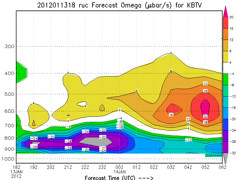
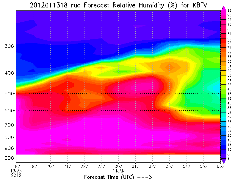
Digging closer we see tremendous upward motion between about 5pm and midnight.
and decent snow growth temps through the layer of upward motion
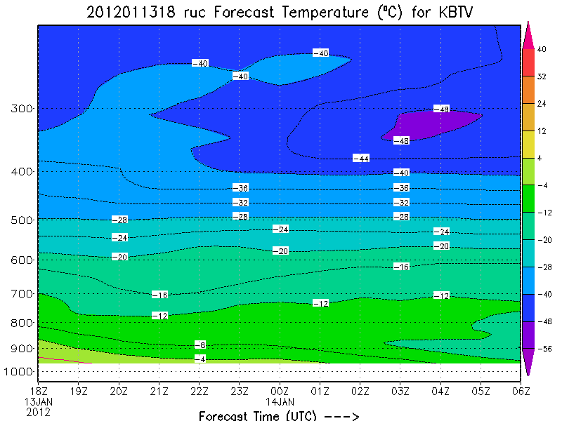
We should see VERY solid snowfall rates between .5 and 1.5 inches an hour depending on the dendrite growth.
I think when all is said and done we will be well into that 6-12 range I originally forecasted and like I said below somebody is coming away with 18 total. This pattern tonight DEF has the possibiltiy of popping off and dropping an additional 8-12 of snow somewhere along the spine. AND if you want my suggestion as to where that might be…well I’d say somewhere between MRG/Bush/the Midd. Snow Bowl / Kmart. Seriously…it’s running that way for sure.
Friday Jan 13th, 9:30AM update
So Here comes Acts II and III of Easy.
Right now a strong low has developed with it’s surface center just off the NY border north of Watertown. Here is the 850mb meso analysis of the system.
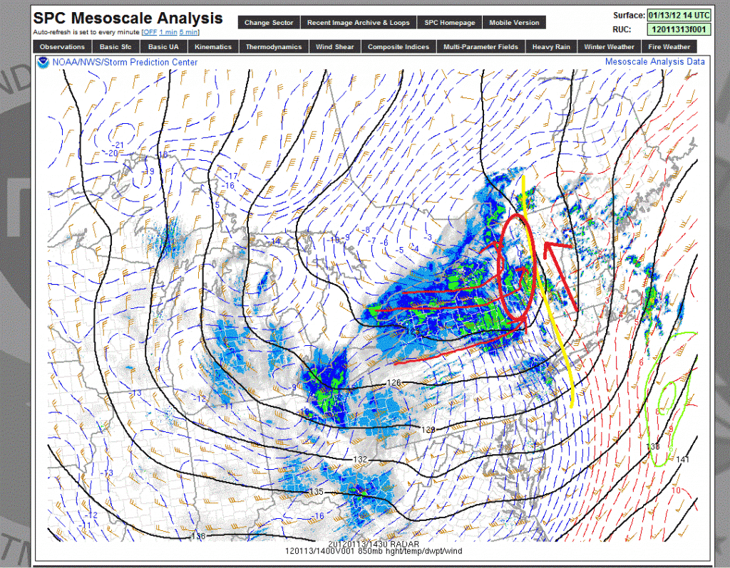
It will track northeast across the border over the next 10-12 horus. As it does it will push a strong cold front through the region ( Marked in yellow) Strong southerly winds out ahead of it in VT and NH are keeping mid level temps just a notch above freezing. (Red arrows to east of yellow).
To the west of the front strong winds from the west are whooshing in a lot of cold air and entraining significant moisture. Noted in the red streamlines in western NY there is also a large degree of convergence behind the front from these winds. That will grealy aid in uplift and convective precip.
Overall once that front pushes through we’ll see snow and falling temps. Heaviest snows are going to be in the ADK, and Greens from KMart to MRG. Stowe/Jay might get shadowed a touch from this pattern.
As the winds really stay westerly…the upslope machine kicks in around 10pm tonight with possible a very heavy period of like 2 inches per hour snowfall rates.
Overall I’m going with 3-8 inches additional today.
Jan 12th 12:45PM update:
Storm has started to bring rather steady snows to the Greens over the last few hours. Waiting on reports from the ADK. So far looks like as expected the WAA on the east of the storm has brought a solid 3-5 inches in southern sections of VT and Mass and it’s still snowing. Storm isn’t that well organized and starting to merge into one large low blob. Which is ok. looks like the 12z suite of high res models is handling this well.
Speaking of, I’m now tuning into that period from Friday thru saturday morning. Looks like we’ll see .75 to 1.25 inches or water from Friday morning through Saturday morning along the ADK and Green spine.
and
Certainly some of this will fall as mixed precip (sleet, ice and drizzle) over the day on friday. However, as I’ve discussed below much of this will fall as snow during the later hours of friday and early saturday morning.
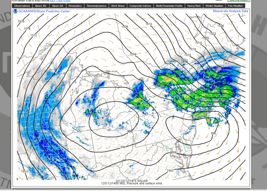
Jan 12th 9:38AM update: So this is where we currently stand:
you can clearly see the double low structure that I referenced in the write up below.
Because I don’t have a ton of time I will lay out how this plays out based on the current data and model forecasts.
First today we’ll see that primary low track to the northeast. It will bring light snows to VT, and Northern NH. Heavier snows will fall in central NH and Maine.
Generally there will be a few inches along the ADK and greens – with more on the eastern slopes. Following that light snow, freezing drizzle and misty type precip will reign tonight thru tomorrow midday. Then, that second low – having deepened- will push through. This will be imo the real story and snow maker. The upslope signal is strong from friday night thru midday saturday. With dropping temps snow growth will be right side up so what falls will go from dense to very light by saturday.
Overall I’m still sticking with this being a total 6-12 type event for much of the mountains of the northeast. I made this comment privately and I’ll make it here. If you don’t get above 2500ft you will think this storm is a bust. It’s just going to be that way. Take your time, let it play out and don’t judge it by what falls on your car when it’s parked in the driveway.
ORIGINAL POST from January 10th:
Nope- no intro this time. (Well maybe a short one…if you read “Easy” and don’t think of “Easy Company” 506th Regiment, of the 101st airborne you have not scene the greatest Television series of all time and possibly the best depiction of American men on the Western Front during World War II: HBO’s 10 part epic Band of Brothers. There is little more to say than watch this now. I promise you it will be the best 10 hours you spend this year.)
Back to the weather:
Beginning on Thursday, and running through early Saturday, the North Country has the potential to see a heavy dose of Snow with some rain mixed in.
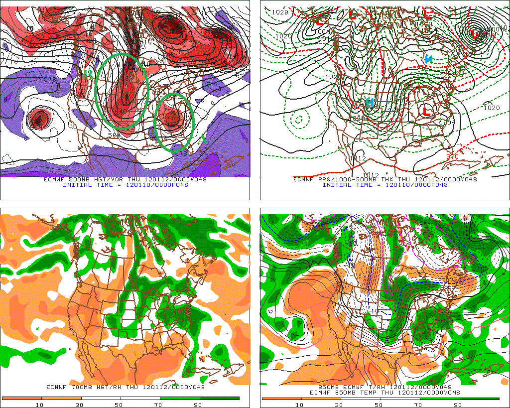
At its base level “Easy” is a storm complex formed by the interaction of two separate systems. First a moist storm moving out of the south (A) and a cold trough moving out of the northwest/Alberta (B).
Models wanted to merge- or phase- these two pieces a number of different ways of the past week. Slowly however it’s seemed a consensus has emerged. Generally it is agreed that by wednesday the southern low will be over Virginia and the northern energy will be developing a storm over the great lakes.
This is the moment it gets “interesting.”
Models have a very hard time with the complex interaction between lows and frankly so do forecasters. There are just a lot of moving parts and wind shifts/temperature changes. TO accurately predict what will happen tends to focus more on the “art” rather than the “science.”
Generally however it seems pretty clear that these storms will not totally phase but rather link in a rather unique way. (from the Euro)
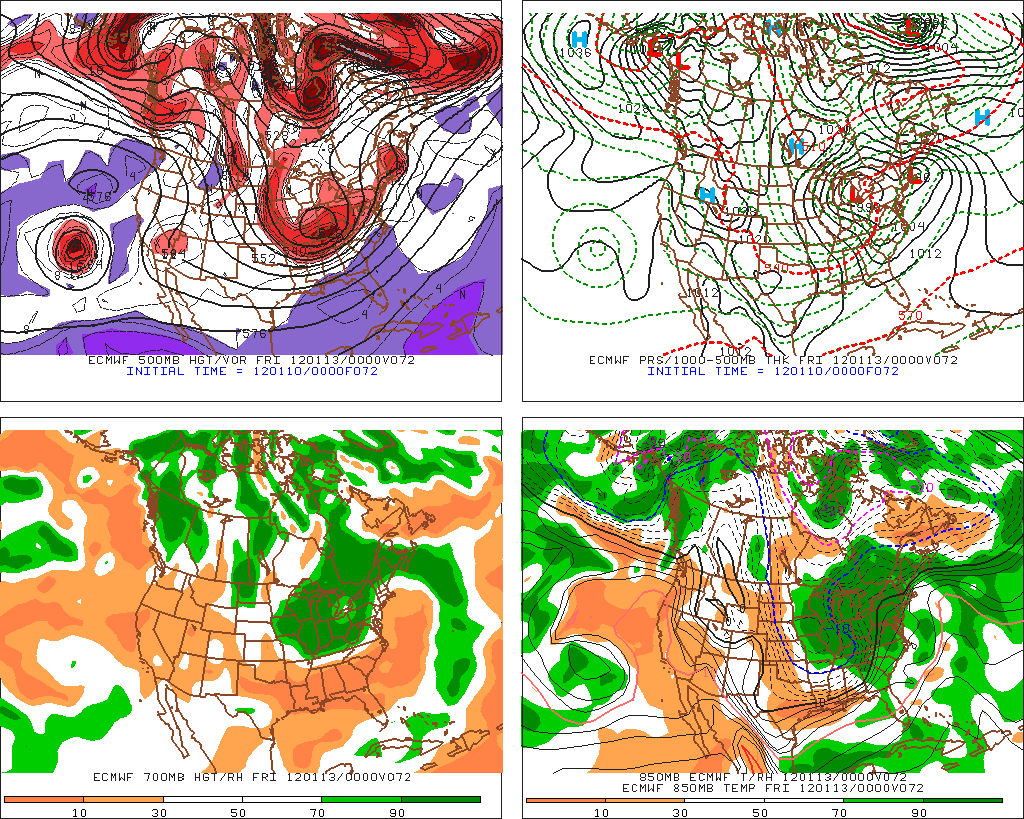
Nor often when something like this happens one of the lows takes over as the primary low. Usually that’s the coastal low given how cyclones form. That however doesn’t seem like it’s going to happen. Rather all the major models want to skirt that primary low off to the east while still dragging the second low up into Canada.
– Of course as soon as I publish this the 12z NAM for 1/10/12 comes out and just decides it wants to make that primary low the story. According to the NAM the Greens and ADK a solid 8-10(+) of snow will fall on thursday, FOLLOWED by the passage of the second low with waves and impusles sparking snowfall through saturday. DO I buy this soluition totally…well not quite…read on…
With that said, I think the following plays out…
1) The primary (or southern low) tracks up into southern NY state. VT and the ADK seen WAA snows on the “front end” with a passage to some mixed precip and periods of heavier snow on Thursday.
2) As that primary low moves east, the lagging more vertically stacked “secondary” low- the northern low will slowly drag across the ADK/Greens Thursday night and Friday. While the models don’t throw a ton of moisture out, I think there is plenty to be had. Once the high res models come in line I’d not be shocked to see enough water to get us to a foot of snow. These lagging moist lows are just great for the greens.
3) A weak impulse may ride up a secondary front associated with this second low late Friday. That would spark additional snowfall in Vermont- esp. southern and central VT.
4) As the second low moves out into Maine, we’ll see a period of solid upslope snow from Friday to Saturday.
So what snowfalls are we looking at? Overall- when all is said and done I think it’s VERY possible somewhere along the Green Spine and ADK will be over a foot with the potential to get into the 18 inch range if that second low tracks a little south right over the spine. Otherwise I think this is a solid 5-10/6-12 type event
across much of the North Country (at elevation). Further south I think southern VT could fall in that 4-8 range. Interestingly a low level moist easterly flow at the outset may spike snowfall rates in the Whites putting MTW in that 6-12 range.
-Maine Bonus: On the advice of a wise friend, I’d like to add that the Sunday River/Sugarloaf region could get a real hammering as well. During the first lows life, a strong southeast flow off the ocean will develop and funnel moisture right into Maine. Should be cold enough for snow at both SR and the Loaf. The result will likely be a 8-16 inch snowfall event for them by friday afternoon.
Caveat Conclusion: This is a very complex event that models have not handled well at all and I think there are some assumptions that just might not play out. Am I totally confident this stays all snow? Nope. Not at all. Am I confident that Easy isn’t just another warm rain storm? Yes. We’re going to get snow out of this and somebody along the spine is going to get a fair (possibly VERY FAIR) amount.
I’ll keep you posted.
43 Comments
Leave a Reply
|
|||
| Home |





spanky
wrote on January 10th, 2012 at 11:03 amThanks Lionel. It looks like it’ll be some good base building snowfall. And at least it’s not another rain event.
nihiles
wrote on January 10th, 2012 at 11:44 amhmmm maybe its time to check out Hickory…?
(yes im looking for your approval goddamnit)
billski
wrote on January 10th, 2012 at 11:54 amwhere do you think NEK (a-la Burke) will be in the continuum?
Lionel Hutz
wrote on January 10th, 2012 at 12:41 pm1 Trillion Inches.
BenedictGomez
wrote on January 10th, 2012 at 12:22 pmThis is like porn.
Disco Stu
wrote on January 10th, 2012 at 1:46 pmHow fat of skis should I ride in 1 trillion inches?
billski
wrote on January 10th, 2012 at 3:04 pm36,000 should do it.
rocojerry
wrote on January 10th, 2012 at 3:30 pmI’d break out the mega fats
billski
wrote on January 10th, 2012 at 1:54 pmTHAT’S TOO MUCH SNOW! I’d better stay home or I might die.
Mike D
wrote on January 10th, 2012 at 1:58 pmThank you LH! a potential 4-Trillion inches is just what this season needs!
Cat in January
wrote on January 10th, 2012 at 3:03 pmThanks for the Maine forecast.
teleskiqueen
wrote on January 10th, 2012 at 3:31 pmAlthough a trillion inches would be nice, I’d welcome a foot of snow in the Adks! Fingers crossed here at HQ. Thanks Lionel.
Aaron
wrote on January 10th, 2012 at 6:19 pmA Trillion inches? Geeze, everything is bigger at FIS.
MadPatSki
wrote on January 11th, 2012 at 10:40 amWould this be our Valentine Day 2012???
New love and new beginning for the 2011-12 season?
Praying Ullr.
Lionel Hutz
wrote on January 11th, 2012 at 11:51 amNo. V-day 2007 was a textbook phased nor’easter. “Easy” is not that. Easy is a storm complex made up of several distinct pieces of energy.
MadPatSki
wrote on January 11th, 2012 at 12:05 pmLionel, I was referring more to the turning point of a bad start to ski season à la 2006-07 that to the storm itself. Although there was some good skiing to be found prior to V day 07, the storm marked the point in the calendar where it changed from subpar winter to awesome. That is why I’m praying Ullr (although my locals look great, everything has been white since Christmas, but there much snow and all the skiing is on man-made stuff).
toddskiis
wrote on January 11th, 2012 at 12:23 pmAttention all CT, NY and NJ skiers, it will absolutely NOT be worth it for you to ski this weekend.
billski
wrote on January 11th, 2012 at 12:30 pmYou sly fox :)
Yay Snow
wrote on January 13th, 2012 at 4:36 pmYeah, it really isn’t snowing out. Man! This rain is killing our winter!
heehee
Phineas
wrote on January 11th, 2012 at 2:56 pmAttn all skiers/riders; it will def be worth it to rip Whiteface this weekend!
WF is in awesome shape heading into this storm due to our superior snowtribe!!
Lionel Hutz
wrote on January 11th, 2012 at 3:01 pmCan’t argue this. Likely going to be less temperature issues in the dacks. Not a bad place to ride out 8-12 of fresh snow.
Phineas
wrote on January 11th, 2012 at 3:01 pmI once watched all ten espisodes of Band of Brothers in one marathon D-Day session! Capt Winters please make it all snow this week and for the rest of the season! You da man!
William Guarnere, an 88-year-old veteran who served under Winters in Easy Company recalled, “He was a good man, a very good man. I would follow him to hell and back. So would the men from E Company.”
Phineas
wrote on January 12th, 2012 at 8:01 amSnowing in Wilmington. Presently a light snow. Started about 30 minutes ago.
We did a brewski up the toll road last night. great conditions above 2300 feet!! And wow what a moon-scaped sky!!!
teleskiqueen
wrote on January 12th, 2012 at 11:25 amWhiteout conditions at HQ near MVH in LP as I type. Go Easy!
Steve
wrote on January 12th, 2012 at 11:56 amNewbie here: do most mountains where the bigger ski resorts reside in NH/ME/VT reside at 2500+?
Greg
wrote on January 12th, 2012 at 1:03 pmmost of them get above 2500′
Phineas
wrote on January 12th, 2012 at 1:15 pmHey Steve,
Whiteface Mountain is located in the Adirondacks of New York State. It sits in the Town of Wilmington.
Here are some mtn stats:
Base Elevation: 1,220′
Little Whiteface Elevation: 3,676′
Lookout Mountain Elevation: 4,000′
Highest Lift Terminus: 4,386′ Top of Summit Quad (Chair 6)
Highest Skiable Terrain: The Slides at 4,650′
Peak Elevation: 4,867′
teleskiqueen
wrote on January 12th, 2012 at 2:14 pmUpdates from the Adks…..4 inches already on the ground here at 2248 ft. near Mount Van Hoevenberg in Lake Placid and we currently have heavy snow falling with near blizzard conditions.
Lionel Hutz
wrote on January 12th, 2012 at 3:49 pmThat’s great. Reports of 5 or so at whtieface.
I
wrote on January 12th, 2012 at 3:54 pmAttn all skiers – go to VT so there are more fresh tracks in the ADK!!!!
Steve
wrote on January 12th, 2012 at 7:00 pmOK!
NS
wrote on January 13th, 2012 at 4:15 amWINDY…WINDY at the VT Bowl…Not operating thurs…..DEEEP Drifts…Ice, Hardpack, Groomed Crapola….Hiked for some turns…Worth the effort as always!
A. G.
wrote on January 13th, 2012 at 10:43 amJust started getting absolutely dumped on in the Northern Berkshires, the mist we had this morning just picked up and turned to huge flakes. This wind is something else too, just crazy out there.
Yay Snow
wrote on January 13th, 2012 at 4:34 pmHi Lionel,
The berkshires are picking up more than what was suggested. This is good! Any idea of how much more you think could fall on us?
Thanks for the great reports!
DrF
Lionel Hutz
wrote on January 13th, 2012 at 4:45 pmThis is true. Stayed cold and moist down there. Guess maybe another 3-5 or so.
JJ
wrote on January 13th, 2012 at 5:11 pmNice Job LH. Dumping (and howling) in the Mad River Valley at 5PM!
Disco Stu
wrote on January 13th, 2012 at 6:47 pmGood news, thanks!!
Does any of this hit WHite Mountains?
Greg
wrote on January 13th, 2012 at 7:09 pmwin
Luke
wrote on January 13th, 2012 at 10:00 pmhey it stopped snowing at sugarbush, will that be it for the night most likely?
Funker
wrote on January 14th, 2012 at 6:40 amLooks like a nice little blanket. About 6-8 inches in central berkshire.
Not much wind here through the night, the trees still look like they were dipped in white paint.
Have fun today!