Update: Chances still high for snowfall within the next 48 hours
I’m going to start out with a text based update here and if I have time later today try to get some maps up.
If you have been following Scott and I you would have learned last week that chances were good that the higher terrain of the greens and adirondacks would see the first real snow showers of the season this week.
Well were now within 48 hours of the event and all the computuer models still indicate conditions will be favorable for an upslope enhanced northwest snowfall event. (For those who think this sounds like weather babble- stay tuned- I’m going to post up a tutorial on these systems before november).
At this point the Euro, the GFS (operation and ensembles) all forecast 850mb temps (5oooft) to below zero C over the greens and ‘dacks. With the ‘dacks seeing the coldest temps. Also all the models show consistently high relative humidity values (important because the air needs to reach saturation before snow falls) and consistent NW flow from the surface through 500mb.
Surface temps will be lowest in the adirondacks where they will hover in the low to mid 30’s so snowfall will certainly be able to accumulate on colder grassy surfaces. In the greens the temps may remain slightly higher so accordingly the snowline might be a little higer. However these NW flow events tend to produce more snow in the greens as their spine is directly in front of the prevailing flow.
All in all I’d say wed. night/late afternoon into thursday morning some snow showers will pop up. Look closely at the whiteface toll road and Mansfield road for some flakes to accumulate. I’d say AT best you could see 2 slushy inches way way up at the top….
Confidence Increasing on High Elevation Snowfall Later This Week
Before you get too excited, let me state that a best case scenario out of this is a couple inches of wet snow above 3,000ft but I do think later this week the lofty ridges of the Greens, Adirondacks, and Whites will be coated in white. Dare I say it might even be enough for some low angle junk board skiing/riding on things like the upper reaches of the Toll/Auto Roads on Whiteface, Mansfield, and Washington?
Our first strong autumn storm will deepen on Monday and Monday night over the northern Great Lakes region as the mid and upper level lows cut off and become vertically stacked just north of Lake Ontario. Once the upper levels become cut-off from the main flow, the surface low will slow considerably and on Tuesday and Wednesday it just drifts northeast up the St Lawrence River Valley into northeastern Quebec. There will be some synoptic precipitation associated with this storm on Tue/Wed as it passes north of the border but that precipitation will be in the form of rain.
As the vertically stacked system moves off to our northeast in Quebec, winds at all levels of the atmosphere swing around to the northwest later on Wednesday. This is very important because the precipitation will transition from synoptic to mesoscale in nature, focused heavily on the upslope regions of the northern Adirondacks and northern Greens. As this is happening, the deep layer NW flow will drill cold air from Canada into the Northeast. H85 (850mb or ~5,000ft) temperatures on both the European and GFS models drop to between 0C and -4C on Wednesday night and Thursday amid the moist cyclonic flow. Since the system is cut-off from the main flow and is vertically stacked, we will have no problem wrapping moisture back into the northern mountains and as this moisture interacts with the cold air push out of Canada, snow levels should drop rapidly to between 3K-4K ft on Wednesday night then hold there through Thursday in the chilly northerly flow.
This will become primarily an upslope event on Wednesday night and Thursday and I feel the models are under-estimating the amount of precipitation that falls during this time frame. Relative humidity values remain high between the surface and the H7 level and wind speeds at H85 (near ridge top level) are forecast to be between 25-35kts out of the NNW during this time. This is marginal but higher than the 25kt threshold for upslope precipitation production. This should produce a decent cross barrier flow into the northern Adirondacks and northern Greens and as the maritime moisture (wrapping around stacked cut-off low to our NE) is forced into the topography, we have a significant mechanism for precipitation production. Couple that with the cold air being drilled in from Canada and we have high elevation snow baby!
Now, seeing as this is still 5 days away there are a lot of details to be worked out. The situation is extremely marginal and the amount of cold air we get in here, as well as the placement of the low to our NE, will dictate the amount of precipitation that could fall as snow. The models are in decent agreement with the overall situation but there’s a big difference between H85 temps of 0C (slushy coating possible at 4,000ft+) and H85 temps of -3C (a couple wet inches possible down to 3,000ft). Also, if the low pressure tracks further north and east than progged, it will reduce the amount of upslope that occurs when the cold air is in place as we’ll have a weaker wind flow and be further removed from the moist cyclonic flow.
Bottom line: Stay tuned.
Potential for First Flakes in the Northeast!!!
No shit. I’m hesitant to post this because I don’t want to be that guy…you know the guy that screams “IT’S GONNA PUKE” as soon as any weather model hints at a snowflake. However, I feel like the possiblity of seeing a real, honest coating of snow above the higher terrain of the central ‘dacks and greens can’t pass without at least a heads up to ya’ll. So with the usual disclaimer that I’m talking about the weather which does what it wants…here we go:
While, last weeks cold snap was nice, it’s larger and angrier brother is on the way next week and with it’s arrival, comes the chance for the first snow showers of the season across the higher terrain of the Adirondacks and Green mountains.
Here’s the Scoop:
Over the weekend a large and strong low pressure system will develop over the northern plains/great lakes. With it will come a strong cold front that will bring very high winds and raw weather across the great lakes as the weekend ends and the week begins.
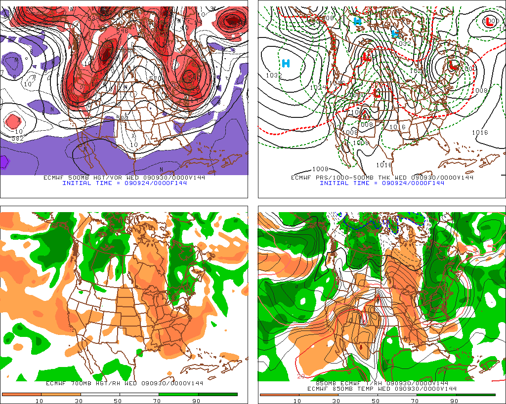
By monday, the low will track north of the border, and drag the cold front across the north country. As the low becomes vertically stacked and stable it will sit and spin in northeastern quebec. The flow of air around the low will direct air from the northwest over the lakes and then east over the adk and the greens. You can see that in the four panel map below.
As night falls on tuesday, the low will have brought enough cool air into the region to bring higher elevation temps down to below 0c.
At the same time the wind will remain steady from the east, bringing moist air into the cooler air.
Were this the winter time we would be talking about a pretty decent snow event. But it’s not winter. So what does all this add up to you ask? Maybe a coating above 3000 ft. Just enough to make us all remember how much we love winter; How much we love starting into the woods when the fresh snow sparkles as the rising sun’s rays filter down through the trees and nothing besides you moves in the below freezing woods as all you hear is the sound of your skis swishing through the snow with the rest of woods’ creatures tucked away from the harsh cold.
Importantly it’s worth noting that the shear will be pretty low so moisture will be able to travel pretty far. Places like Kmart could def see some of this action (if I can call it that).
The Euro (another forecast model) is less agreesive with this and generally doesn’t depict the same chance for snow showers. Whatever. We’ll see what goes down.
Euro not as aggressive:
More Internet Fame for the FIS
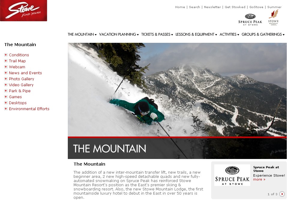
Our famous internet skiing just got even famouser, dangerouser and sparklier, as we landed the centerpiece picture on the “mountain page” for Stowe Mountain Resort. The skier is our buddy Graham who showed up and got his “rip” on for last winter’s East Coast Supershoot at Stowe Mountain Resort, in which I (Greg) was a participant.
Check out the page on Stowe’s website here!

In honor of our new fame, I decided to update my gallery. This probably won’t be the last time that gets done. Check it out here. If the first pic is “Adams in the Clouds” please try clearing your cache, as you are still seeing the old one which is likely stored on your system. On windows machines “ctrl+F5” usually does the trick. On a mac “cmd+shift+R” should do it. (apparently this website is also about famous internet keyboard shortcuts : )
FIRST SNOWFALL!
Well not here..sorry about that…but I had to get your attention somehow!
The first real snowfall of the season is coming. Starting today, a broad upper level low which is parked over Kansas will send moist cool air into central Colorado.
Uplifting of the air into the mountains will force the air to cool, the water vapor to condense and snow to fall.
By the time this all wraps up by thursday early morning, I’d expect some places in Central Colorado- say Dillon/Silverthorne/Ptarmigan Peak- to have picked up almost a foot of heavy snow.
P.S….it’s worth paying attention to this type of storm. As I’ll explain in the next week or so, snow events like the one going to kick off winter in Colorado this week are very important to EC skiers. As the famous internet skiers will tell you, events like these can lead to some fantastic results. Stay tuned for that.


