Weekend Snows to Affect Wasatch (UPDATED ..WITH TOTALS)
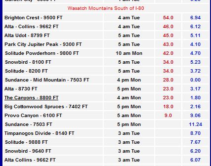
TOTALS THROUGH TUESDAY:
I told you FEETS:
Continue reading Weekend Snows to Affect Wasatch (UPDATED ..WITH TOTALS)
Coastal Storm to Impact Eastern New England But Not Like That
As we head into the weekend a storm is will be brew that could bring heavy snowfall to Eastern New England. Then again maybe not. Ok…so when I wrote that first sentence I was betting on the Euro. Why? Because it had clearly the best verification scores (i.e. sharted the bed less) than the other models with that messy confused system from Sunday into Monday of this week. AND because in the last two Nina like patterns, 08-09 and 07-08 it was the more reliable weather model. So of course when I finally decide it’s time to act, it betrays me. KAAAAHN!!!!!!
ANYWAY…. Continue reading Coastal Storm to Impact Eastern New England But Not Like That
WSW Flow brings snows to Greens and ADK (UPDATED)
Quick Report:
The wind has turned brifely and is bringing moisture from Lake Ontario into the ADK and Greens. This is a WSW flow and I find these events to be a) under reported, and b) snowy. Now the dyanmics aren’t great as the duration of the flow isn’t that long. However, with great temps and copious moisture in the airmass 4+ inches over the next 24 hours is very possible across the higher terrain. Most accumulations will fall across the ADK High peaks. West facing slopes of the Northern Greens will catch some flakes as well with favored locations matching the totals in the High Peaks. Stay on top of the radar, satellite, and other weather products on our weather page.
K- I’m outta here. Check out the latest SPAM here on FIS, or our VTah part V TR if you are looking for some stoke.
UPDATE:
I love me some SW flow events. As I told you above, and in my winter outlook, these events are sneaky and impossible to really get a handle on but are just AWESOME for area’s like Whiteface (who is reporting a foot), Stowe, Bolton Valley (reporting 7) and Jay (reliably reporting 8-10). Why? Because it’s just the way the moisture transport lines up. That’s why! What the hell did you think it was? Gnomes, Faires and Katie Couric?
SPAM #10: Magic Powder Turn
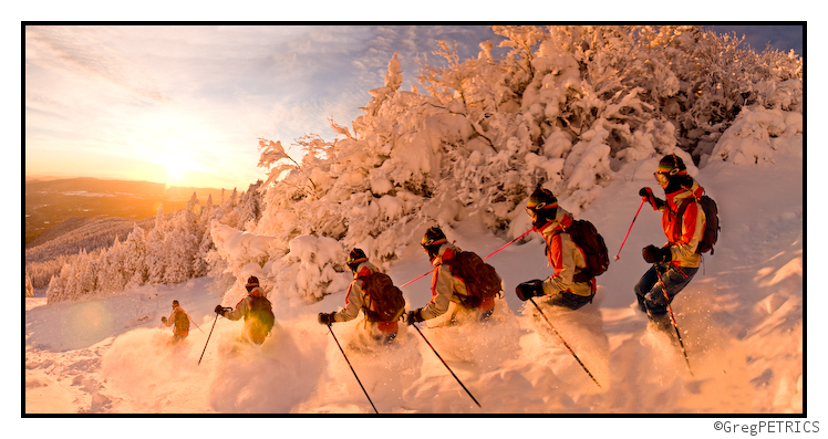
As a follow up to our analysis of the magic behind a powder turn in The POWstige earlier this week, we’ve got a fresh SPAM for your viewing pleasure. Today we’ve got several shots taken during a Vermont dawn patrol hot on the heels of VTah Part V. KC and Greg had business to attend to during “normal business hours,” and so the only option for lapping up some leftover powder was to get on the skin-track at an hour when most are still in bed. A toasty -5F greeted us at the base, and who knows how cold it was at the top. Enjoy:

Continue reading SPAM #10: Magic Powder Turn
Post Frontal Snows…
Morning! Hopefully you all had a great weekend. I did. Sorry about the rains. I believe some help is on the way. Note: I have to make this quick because I need to do some actual work (that’s a total abject lie. I need to do some x-mas shopping online and since our work webfilter is down it’s open season. Amazon.com here we go!).
Anyway…as the upper level low which spawned all of this mess starts to pull eastward and the cold front pushes through, moist air and lower level lift on westerly flow will produce snow showers arcoss the Greens and Northern Adirondacks. I hinted at this last friday when I wrote:
Not much has changed in my thinking since then. Overall I’d like to see about 3-7 inches over the next 36 hours across the highest terrain. Maybe more along the spine of the greens than the ADK over the next period, but since the ADK changed over a bit last night and has more snow already on the ground, it’s likely a wash by the time we get to Wednesday. If we set up right we could see a pocket or two of higher amounts as we have plenty of low level moisture. Part of the problem in predicting accumulations, is the temperature profile in the snow growth region. They will not start out supporting great flake shape development so whatever falls as we change back to snow will not accumulate very deeply. But whatever…it beats rain.
Now…let me leave you with one other thought. I LOVE the upslope potential from late night of the 16th till the 18th. The models have predicted a very reasonable solution similar to what happened just a week ago. And we know how that turned out! I’m watching this very closely and I’ll update on wednesday.


