Well do you like your turkey cold? I do and apparently Ullr might as well. As I hinted last week, the potential existed for a major winter storm around the 23/24th. Well damnit “City Dwelling Dad/Father of 2”, if that isn’t going to be the case!
So here we go.
By late tuesday/early early wedneday morning, a cold high pressure system will slide just east, and flatten out as a storm gathers strength.
Previous model runs had this high either sitting right over the North Country and driving the storm to the south and east, or shrinking back up into Canada like little Mr. Costansza after a cold morning swim. Well no longer. The model consensus at this point is for the high to flatten and hold strong. This will drive the storm just to the south of the North Country. See the predicted track below.
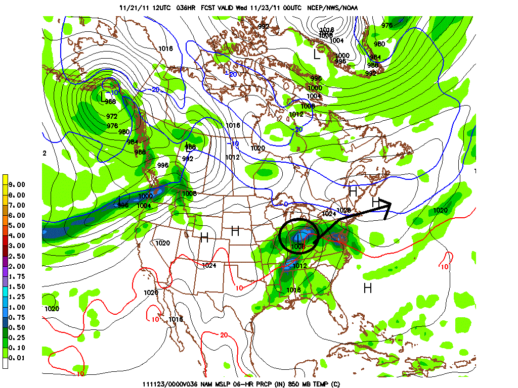
As the storm deepens wednesday the cold air will hold strong across the higher terrain but barely. However the NAM explodes the storm midday wendesday.
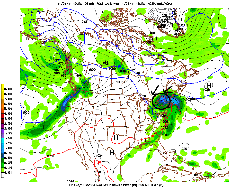
This will allow midlevel cold air to hold strong as the deepening storm will induce greater inflow of cool air from the northeast. This will keep freezing levels across the ADK and Greens at about 2500 feet for the bulk of the event.
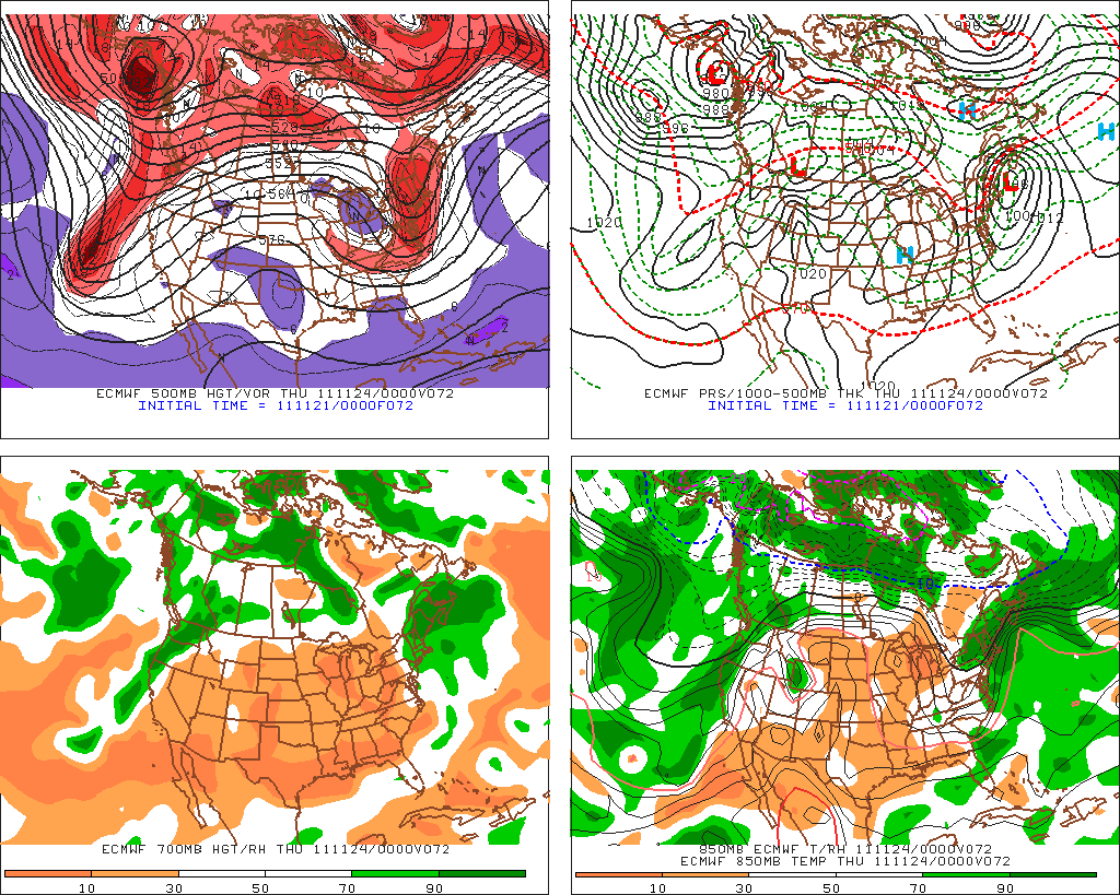
I’ve shown you the nam- and what’s important to note- the GFS and the Euro agree. The Euro REALLY agrees. Bulding:
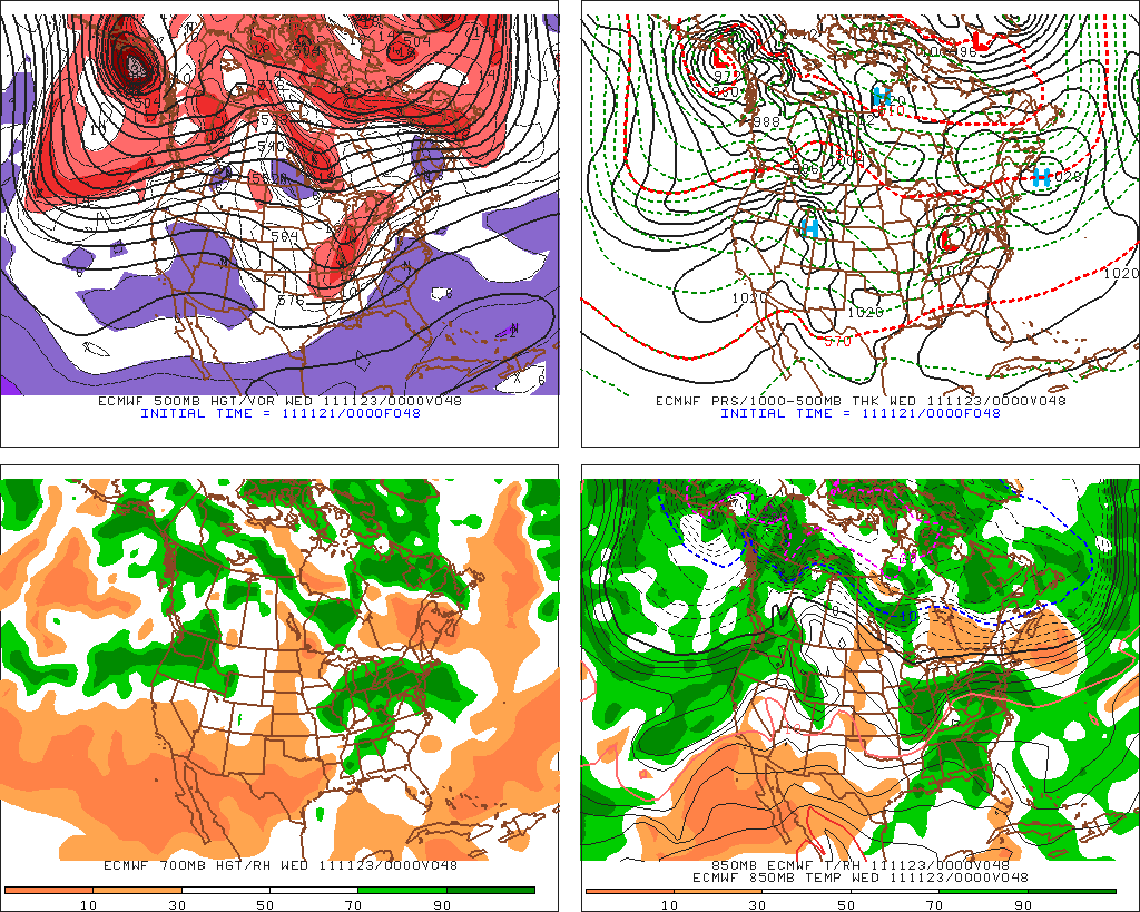
As the storm then wraps up, and swings out towards the NE, the classic backside upslope flow will linger into Wednesday night and thursday AM.
What does this add up to? Well first of all look at the pure water predicted:
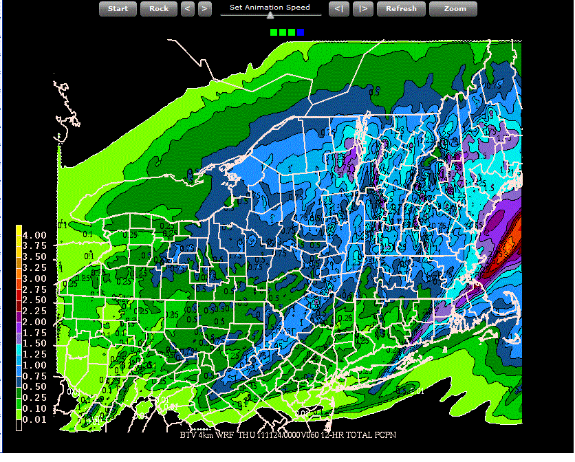
That’s a wet storm. And truth be told, with the warm air movement and the resulting isentropic lift along with the storm’s track and moisture source I think those 12 hour water totals are reasonable. Wednesday could be a wet and wild day. I know…we don’t care about wet- we care about white. So how much? Well there is a reason I called labeled this Winter Storm Charlie. While this will be a heavy, wet snow, I strongly feel that the potential exists for the highest terrain and the northerly terrain to do very well. Above 3000 ft from KMart north to Stowe I think there is the potential for 6-12 inches of heavy snow to fall. In the ADK I think a similar 6-12 is reasonable with the chance for a pocket of more. Jay could be the winner here because of their northerly position and the potential for coldest temps so I’d maybe go 8-16 inches up high at Jay.
A few additional notes. 1) I’m def. concerned about this becoming a sleety mess. Model soundings flirt with the 0c line all the way north to almost 700hpa. So sleet is surely in play (along with of course straight bone chilling rain). 2) A few ensemble solutions take a much more southerly track. I’m leaning NAM here since the NAM really did well with Baker- the Halloween storm. But just be aware that a southerly solution is out there. 3) This doesn’t mean deep winter is upon us. This pattern still isn’t great.
Tuesday AM Update
Looks like the overnight models have converged on a more southerly solution. Heaviest precip looks to be trough central NY and Central to Southern VT. I circled that in black.
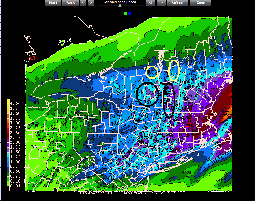
Now there is still ample moisture in the High Peaks (whiteface) and Northern Greens (Bush, MRG, Bolton and Stowe). Circled in yellow. Interestingly because of the temperature profile these areas – despite the differences in quantifiable liquid precip, could come out about equal on the rule test. I’m still comfortable with an overall 6-12 snowfall across the higher terrain. Jay looks less favorable than it did, the whites look a little better and central VT looks a little better. Were this to hold serve as modeled, Kmart’s summit along with the spine up to about the Bush would like be your best bet for finding a pocket of anomalous heavy snow.
25 Comments
Leave a Reply
|
|||
| Home |





powhounddd
wrote on November 21st, 2011 at 5:21 pmwhether the weather pans out or not, It’s good to be able to get excited about SOMETHING winteresque!!!!
neufox47
wrote on November 21st, 2011 at 5:56 pmKinda looks like the Whites and N ME are in the sweet spot, no? Cold air and qpf?
Lionel Hutz
wrote on November 22nd, 2011 at 5:03 amIt does look like the whites are in store for up to a foot of snow at higher elevations. Same with the Sunday River region of Maine.
Aaron
wrote on November 21st, 2011 at 7:55 pmThat’s Boner-rific!
rangerjake
wrote on November 21st, 2011 at 11:01 pmStill eyeing the 1am T-giving morn slot at Stowe. Just dark and cold and wet enough to make me do crazy things. I can’t believe I am considering this shit.
Kas
wrote on November 21st, 2011 at 11:04 pmI hope you are wrong and it is all rain. I have been enjoying this warmer than normal November.
Anonymous
wrote on November 22nd, 2011 at 8:23 amDISLIKE (the comment)
rippah
wrote on November 22nd, 2011 at 8:31 amI think you may have arrived at this site in error…this site is for SKIERS
Lionel Hutz
wrote on November 22nd, 2011 at 9:34 amI’m assuming this is the anti-jinx.
Kas
wrote on November 22nd, 2011 at 2:18 pmFormer ski racer,etc. Used to live for it. Now take it or leave it. Mostly leave it. Would rather be able to get a decent amount for my house and move to more hospitable climate. Did n ot ski at all last year even though I can do it for free. winter has become a drain.
powhounddd
wrote on November 22nd, 2011 at 9:03 pmplease kindly close the door on your way out. ;0
Brian
wrote on November 22nd, 2011 at 9:59 amI hope this pans out for you guys! It’s looking more promising for the Midatlantic and New England as we get into the first week of December. Highs in the 30s and low teens at night. It’s about time. I shouldn’t be running around in shorts and a t-shirt in the last week of November its just bizzarre. Skis waxed and loaded.
Whitewoodchuck
wrote on November 22nd, 2011 at 10:26 amthanks for staying on top of this one – love the late breaking trends for the whites!!
buckethead
wrote on November 22nd, 2011 at 5:36 pmthanks for the update lionel – looks promising.
kas : hope you can sell your house and get to a warmer climate.
maybe looser clothing and a new emphasis on turns in deep+soft snow might change your outlook in the meantime…
Kas
wrote on November 22nd, 2011 at 10:30 pmNah no interest anymore. Bring on global warming.
allymayseuss
wrote on November 22nd, 2011 at 6:07 pmexcuse me mr. kas. You can take your negative nancy, salty sally, debby downer attitude, to the warm atmosphere of florida. Pack your bags and bring a coat, and hit the road jack. Thank you and have a wonderful chilling thanks giving.
Kas
wrote on November 22nd, 2011 at 10:35 pmBelieve me, I would if there was any value at all at this point to VT real-estate. I do however appreciate the detailed weather forecast. I have skied more over the years than most people could in 10 lifetimes. Year after year of dreary dark and cold surrounded by the toothless gets old.
cliffy
wrote on November 22nd, 2011 at 7:01 pmBring it on!!!! WFH at a minimum…
cliffy
wrote on November 22nd, 2011 at 7:07 pmPS – Kas….don’t rain on our snow parade.
Kas
wrote on November 22nd, 2011 at 10:27 pmBet you don’t have to live in it, just travel to it when you want to ski.
Greg
wrote on November 23rd, 2011 at 7:14 amWhile I don’t agree with Kas, all opinions welcome here! Thanks both of you for reading!
Greg
wrote on November 23rd, 2011 at 7:15 amPS Kas: sorry about the delay on your comments. I don’t know why, but they keep getting marked as spam. I’ll try to fix that ASAP.
powhounddd
wrote on November 22nd, 2011 at 9:04 pmmmmm…. anomalies…
Adam Klein
wrote on November 23rd, 2011 at 7:46 amsending it down to killington now, hope the rain/snow line stays south!
YoMomma
wrote on November 23rd, 2011 at 10:39 amHey Kas, not to feed the troll but if “year after year of dreary dark and cold surrounded by the toothless” got so old, why did you do it “more than most people could in 10 lifetimes?” Sorry ab your house and situation but you’re really bringing the party down. Why not just absorb the weather reports and keep your mouth shut? If it wasn’t for the kindness of SKIERS like FIS, you wouldnt even have the reports.