Dy-no-mite! Powerful Storm On Tap for Much of NY, VT and NH
No need to beat around the bush on this one. Another powerful storm is aimed straight at the heart of the Northeast and it’s locked and loaded to deliver some serious moisture into ski country.
WED. AM UPDATE
Looks like the storm has occluded. The center of surface low pressure is off in Ohio, a deep flow of warm air advection is funneling precip throughout the NE. It looks like given the occlusion that heavy snow will fall through the ADKs and Greens throughout the Morning. A dryslot will work through the Catskills as the storm wraps itself off from the primary low in the Great lakes. A few more specifics. Looks like a very heavy batch of snow is about to punch into So. VT. While the bright banding could be sleet, thermal profiles say it’s all snow. Tough to tell but I’m siding with snow. Further north the snows will remain steady for at least the next few hours.
Now here is something interesting as well…looks like we’ll get a second round of snow showers (some heavy) as the upper level low moves through the region later today and tonight. How much snow we get from this will be hard to tell. However I think if we roll all the parts of the storm together (yesterday, today, and snow showers tonight) we’ll be right in range for the totals I laid out below. Maybe a little lower in the Cats but overall pretty close.
Tuesday Afternoon Update:
I’ve been really looking closely at the development of this system and while I still feel strongly that the catskills will see a heavy snow event, I think sleet will mix in rather significantly there. Magic still looks to be in the honeypot. However new data suggests that an upward adjustment of snow totals up and down the spine of the Greens and the ADK may be necessary. Notably, models are beginning to develop this into a more occluded system as it moves through the NE. This changes the storms overall shape and essentially changes its precip spread. I’m not going to get too techy here, but if this does occlude more than previously predicted then the north country would see a robust period of snow as the occluded low moves through early early Thursday am, while areas to the south would see less snow as they would fall under a conveyor of cold dry air at the same time. This wouldn’t mean the south gets “drysloted” over all, just that there would be this overtime period of snow for the North Country previously not forecasted by any model data. Right now it’s hard to anticipate whether this more occluded solution will play out. It would require almost no coastal development to take place. Which is somewhat unlikely. However climo suggests early occlusion as storms this strong in the upper Midwest tend to close off…..regardless…there is still a great storm coming and I’ll keep you updated.
Tuesday 6:15 am UPDATE![]()
Well, batten down the hatches and lash down the main-sail because a storms a comin’.
First will be a little left handed jab. It’s moving through the catskills right now and will streak n/e bringing snow showers to much of the region. Total accums today will be 2-5 from this jab. Then the big left cross comes in overnight to deliver the knock-out blow.
The High Res models have now gotten within range and modeled the storm’s first 80%. It looks really good is all I can say. The Catskills (PKill, Belleayre), So. VT(Magic, Stratton, Mt. Snow) and the Berks are going to get SMOKED. 2 inches of water are totally possible when all is said and done, along with thunder-snow and periods of 2+ inches an hour during the day wednesday. Some sleet will mix in in these regions with less sleet in So. Vt. Awesome. Further north, I’d expect 12-16 inches of lighter snow to fall in the ADK and Northern Greens. Lightest totals will be north into the Stowe and Jay region.Over in NH (See I told you I’d say something) I’d expect 10-14 inches to fall in the whites. Similar totals should fall in the Maine ski areas as well.
Advertisement: Ohh…$14 dollar lift tickets to Burke Mountain tomorrow…that could be good !!
Monday Discussion
Ready? Here we go:
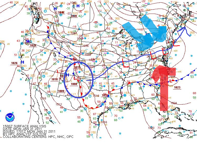
Currently a vigorous shortwave is plowing into a stationary cold front across the central united states. As cyclogenesis occurs along the front, the upper level trough will sharpen and deepen the storm, drawing the center of low pressure up into the upper Midwest. As the system deepens it will tap a substantial amount of Gulf of Mexico moisture with the warm air conveyor belt feeding into the system from the south.
Once the storm reaches the upper midwest, it will make a right turn and bascially travel right down I-80 into PA and NYC.
In the surface analysis below, you can see the overall path of the storm. (The red/blue arrows will be discussed later.
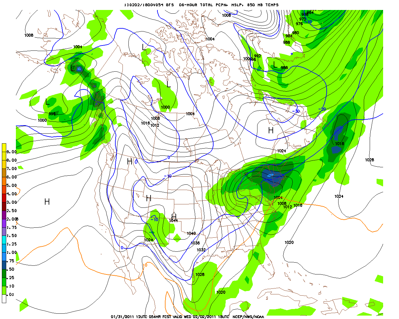
Both the NAM and the GFS strongly agree with this forecasted track. By Wednesday afternoon both models place the system in roughly the same place.
GFS:
NAM:
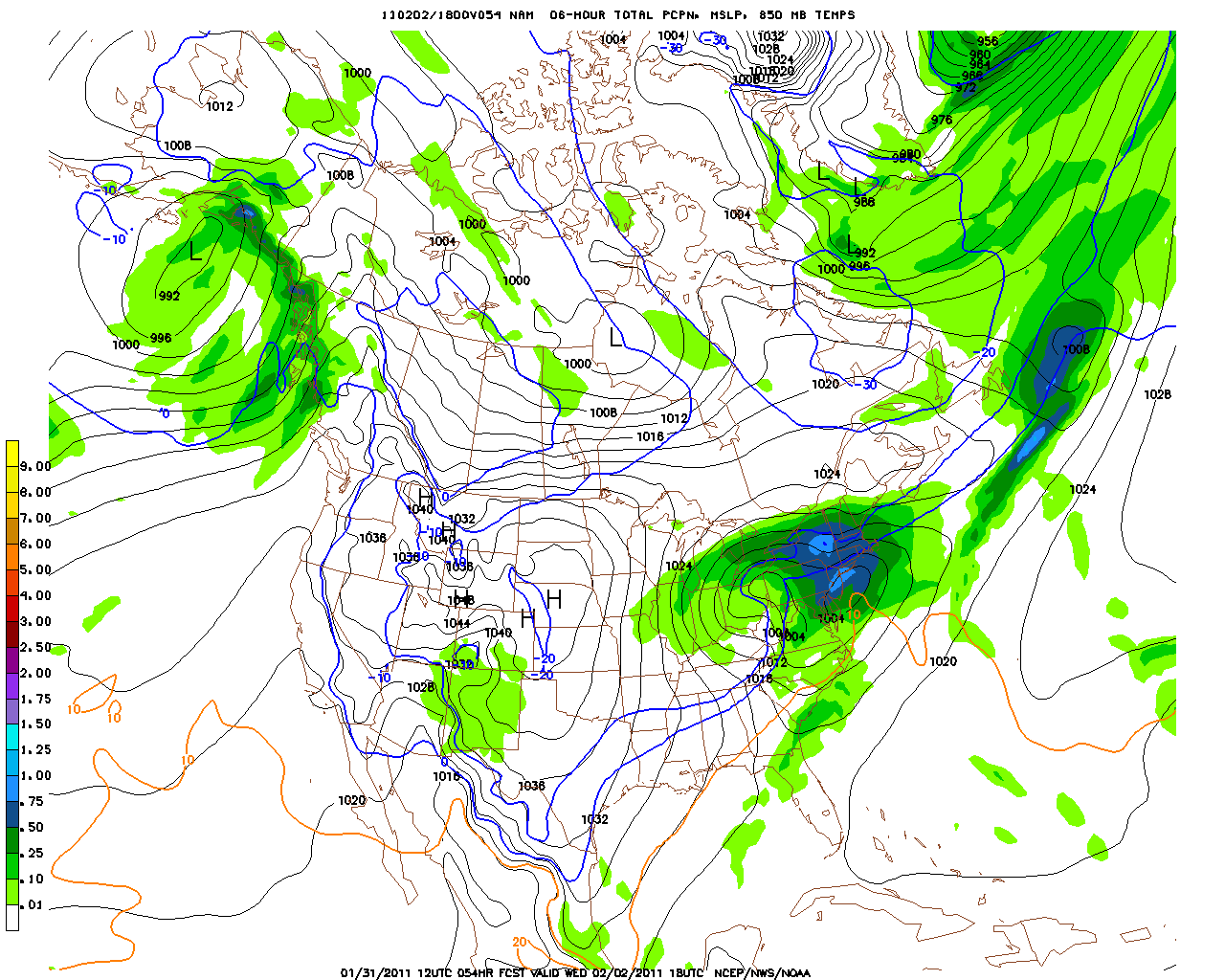
Now you’ll note there are some very lovely blue colors in those images across NY. As the system moves into PA, strong warm air advection from the south (red arrow in above surface analysis) will surge up and over cold entrenched high pressure. There will be tremendous upward motion in the atmosphere with warm moist air shooting up into the cold atm. If you can’t already figure this out, this is a recipe for tremendous snow. Seriously. Warm air advection snows like this can get REALLY intense. So intense in fact that the snow they produce would lead one to say “it’s snowing so hard it’s not just dumping- it’s actually DUMPLIN’ out. ”
Both models show a metric shit ton of moisture in the catskills and southern VT:
NAM:
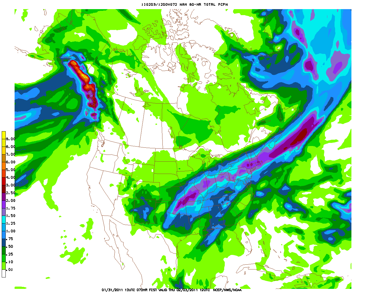
GFS:
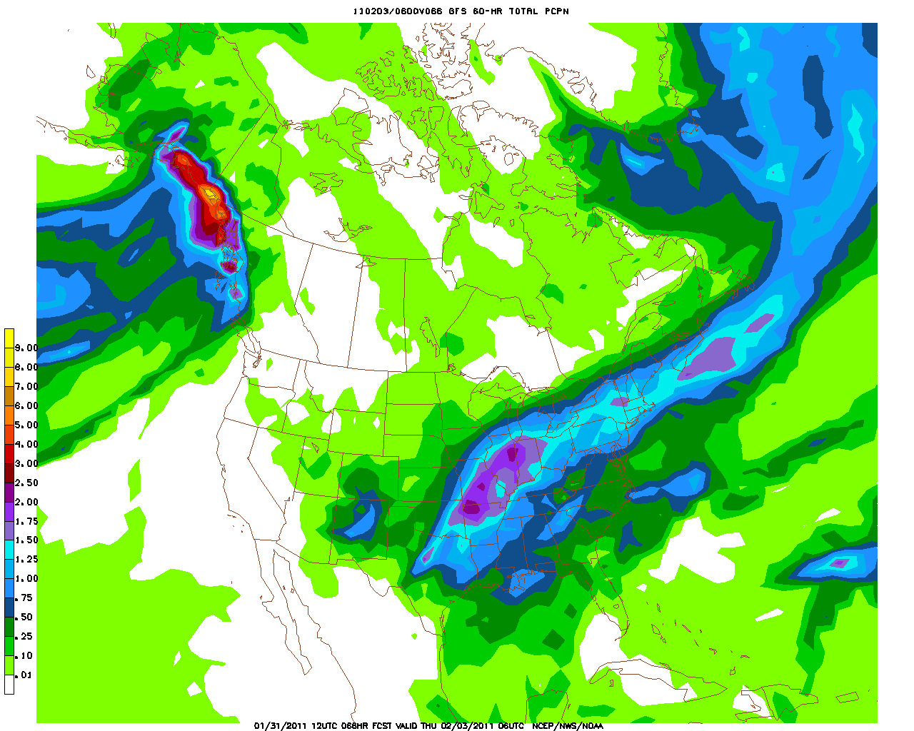
Amazingly, I don’t think these models are really exaggerating on the overall precip with this system. I fully expect between 1.5 and 2 inches of liquid to fall in the Catskills and southern Vermont by early (very) Thursday morning.
Now, with the center of the low tracking so close, and the strong warm air advection, there may be some mid-level temperature issues that would work to change some of this moisture into sleet.
Looking at temp profiles for the southern teir of NY state, we see a pocket of warm air from 900-700mb.
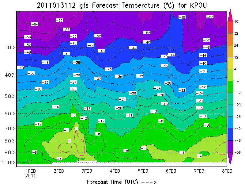
This indicates the that sleet is likely during this system. However, as this profile is from Poughkeepsie which is south and east of the Catskills, I’d expect the atm to be 1-2 degrees cooler in the Catskills. Just enough to keep much of the storm precip as snow with only periods of sleet mixing in.
In southern VT, the overall atm looks to be cooler. 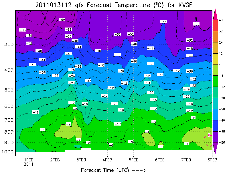
Accordingly, I’d expect less sleet to mix into the system there.
With all the above considered, at this time I expect 12-20 inches of dense snow + sleet to fall in the catskills with pockets of 24 inches highly possible along southeast facing slopes. Further east, I believe that 14-20 inches of snow will fall in southern VT.
Not to be left out, the Adirondacks, and Northern Greens will see some snow from this system. While they will see less moisture, with much cooler temps, the snow that does fall with have better dendritic development and be much fluffier. Accordingly it’s possible that overall totals are suprisingly close. I think right now it’s adivisable to predict 8-14 inches in the ADK and central greens (K-Mart to MRG) and 8-12 for Stowe and Jay. This is less than NWS/BTV has predicted but I’m not really comfortable with their 17-18 inch predictions right now. If the NAM trends further to the North or the High res models indicate otherwise I’ll adjust. But at this time I think those numbers are a tad high.
18 Comments
Leave a Reply
|
|||
| Home |

 Buying lift tickets for a trip you just planned using Lionel’s Forecast? Use Liftopia!



earlyamskier
wrote on January 31st, 2011 at 2:07 pmThanks for the update! It’s about time :)
JohnF
wrote on January 31st, 2011 at 2:36 pmGoing to be driving from Syracuse to NH through Rutland on Wednesday afternoon. How bad are the roads during these storms? Seems like a dumb question but when we get huge LE the roads are continuously plowed. Is that the same for rte 4?
Max
wrote on January 31st, 2011 at 2:54 pmJohn,
You would have to crazy or a masochist or both to attempt that drive. It would be absolutely awful, and this is coming from someone with a pretty high level of acceptable risk when it comes to winter driving.
Lionel Hutz
wrote on January 31st, 2011 at 4:46 pmHmmm: “Shitty, accident filled disasters” comes to mind.
Have fun!
Steve
wrote on January 31st, 2011 at 5:10 pmOh man, I would not want to have to drive from ‘Cuse to NH on Wednesday. I live in Rutland. Plow crews hit 4 good, but expect a mess nonetheless. Especially at Sherburne Pass at Pico. Inevitably there will be a number of cars off the road there and some semis attempting to peak out.
Keep in mind that with LE snows, the snow is confined to a relatively small area. These major storms are so broad that crews are definitely going to be stretched thin during the height of the storm.
Anonymous
wrote on January 31st, 2011 at 5:28 pmGood Points. May be to early to tell but am wondering when the worst will be over on Weds?
JohnF
wrote on January 31st, 2011 at 5:30 pmSorry, that is my comment above.
TSQ
wrote on January 31st, 2011 at 3:47 pm“a metric shit ton of moisture”
Yippee – that means a lot of snow. I’ll take it!
Robb
wrote on January 31st, 2011 at 3:48 pmHow much will the storm impacts the whites?
Lionel Hutz
wrote on January 31st, 2011 at 4:47 pmYea…I kinda wiffed on discussing that. I’m going to add an update tomorrow am and address the whites.
JimH
wrote on January 31st, 2011 at 6:15 pmYes please — thanks Lionel! (Say Cannon, say Cannon, say Cannon…)
Could Be Buggy
wrote on January 31st, 2011 at 4:26 pmPure Dumplage!
icelanticskier
wrote on January 31st, 2011 at 8:53 pmso, no snow for nh? you didn’t seem to mention it. there is skiing here and stuff:) actually, NO! NO! THERE IS NO SKIING IN NEW HAMPSHIRE!
rog
Netman
wrote on January 31st, 2011 at 9:37 pmWhere Can I get a Lionel original hand painted map?
Lionel Hutz
wrote on February 1st, 2011 at 9:19 amRight here…as always!
savantskis
wrote on February 1st, 2011 at 12:47 pmluv it…thanks Lionel always good to get your detailed accounts…stoked
JohnF
wrote on February 2nd, 2011 at 7:30 amMeh. 4″ of heavy sugar snow in Syracuse. Raining on the way into work.
Hope there is better accumulation in the mountains.