I was going to call this post “Roller Coaster of Love” in honor of Valentine’s Day and the fact that temps over the next 5 days will indeed be on a roller coaster. However, I hate roller coasters, don’t celebrate Valentine’s Day (thanks C.B.B.), and was in a surly mood yesterday and flat out didn’t want to post. So we’re ditching the roller coaster of love theme.
Today, any thought of warm air will prob. be appreciated. A COLD high pressure has slid into the region. Biting winds are making temps in the teens feel downright nasty.
However, the rawness will be short lived.
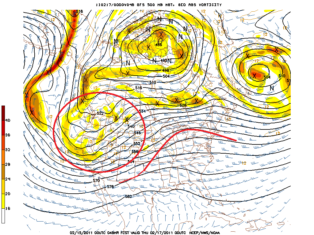
A deep trough as discussed here will move into the west. Down stream of the trough, the buckled jet stream will slide north allowing a strong ridge to build in the east. In the image below I’ve noted the trough moving into the west and the downstream ridge building in the east.
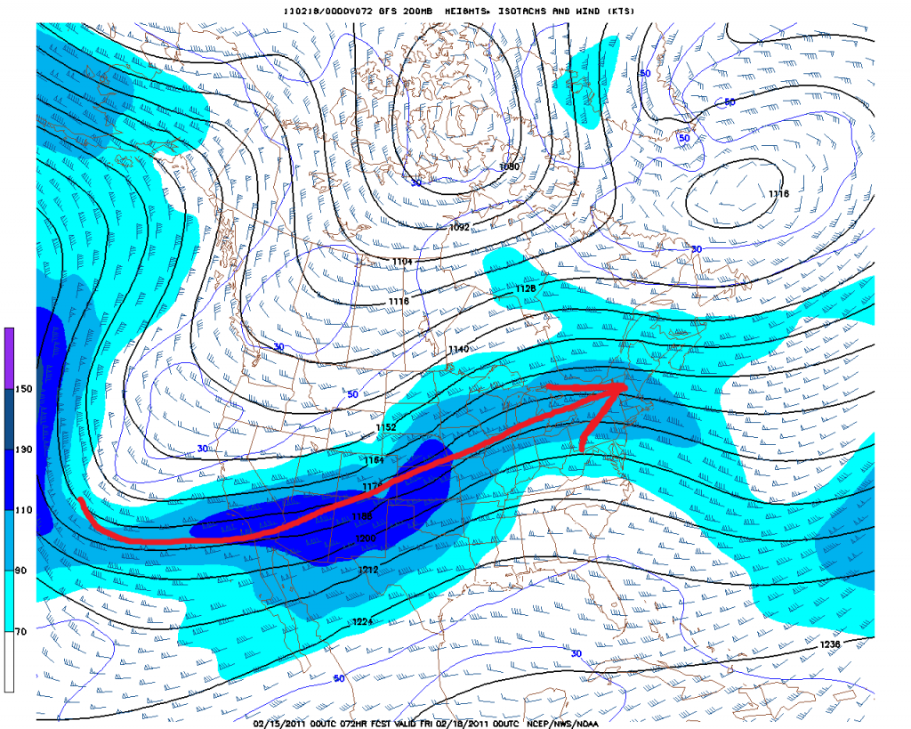
This trough is coupled with the amplification of the Jet Stream. The image below clearly shows the southward migration of the jet in the west, and the northern migration of the jet in the east. Also note that given the projected jet alignment, pacific air will flood into the east on the strong upper level winds.
As the day progresses the trough will move east, amplifying the downstream ridge and squeeze a high pressure system out to sea.
The amplified ridge and STRONG SW winds will scour out al the stale cold air.
Temps will generally spike on Thursday into the low 40s at sea level and low 30’s across the higher terrain.
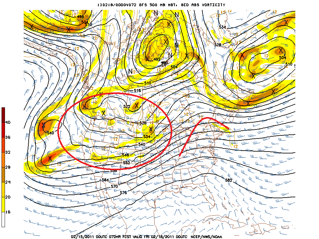
As we move into Friday, energy will amplify along the Canadian border.
As this does it will spike the ridge just a touch more, further turning the temps upward. Highs on Friday will again be in the low 40’s and high 30’s across the higher terrain. A few spots favored for warming in SW winds might make a run at 50. However, sun will be limited on Friday as upper and mid level clouds move in ahead of the amplifying system. There is some chance that low level moisture on Friday will spark some rain showers. Some models spit out from 1/3 to 1/2 an inch from midnight Thursday to midnight Friday. I think that’s a little much. I don’t see this being a “wet” warm up.
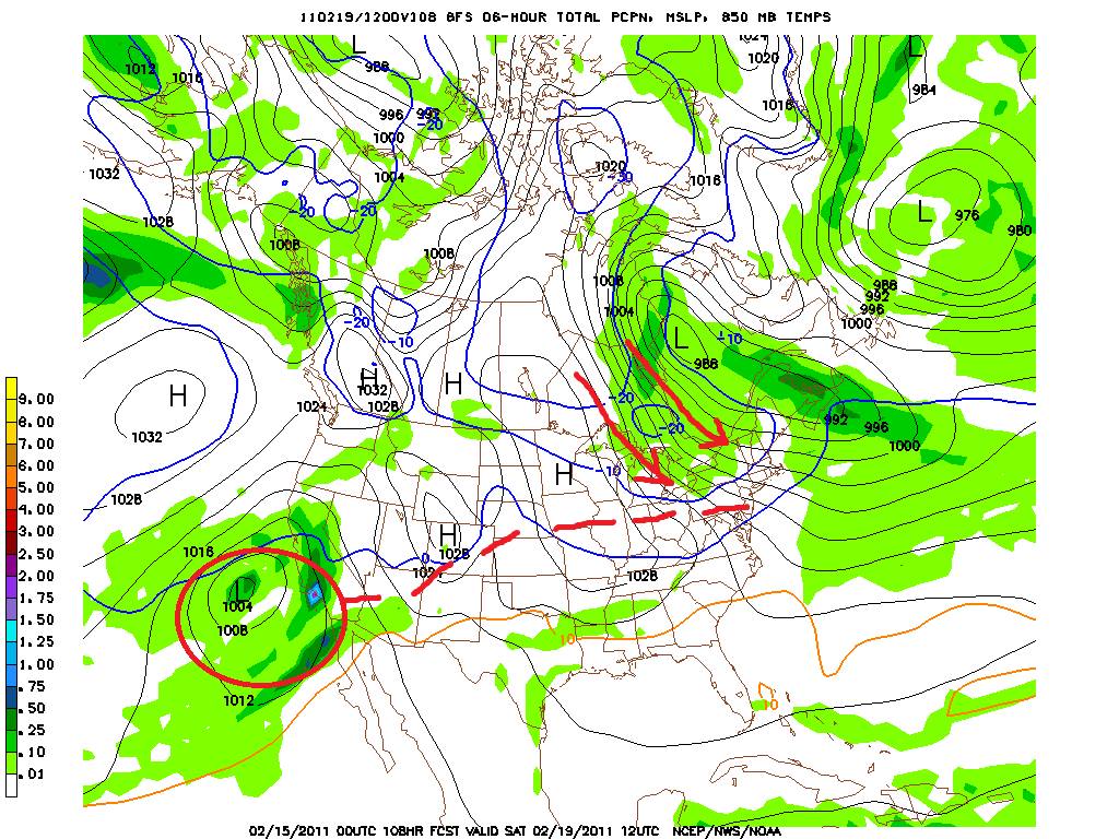
A cold front from the system will punch in from the NW overnight Friday. Strong cold air advection will result in significantly lower temps Saturday. As seen below the flow will be straight outta Compton (I don’t know much about Canada).
With the cold N/W flow and decent relative humidity I’d expect some strong upslope snow showers throughout the day Saturday. Bufkit is giving Jay, Stowe and the Nor. Greens almost a foot. That seems high right now but lets agree to watch the orographic signature as we move into the weekend.
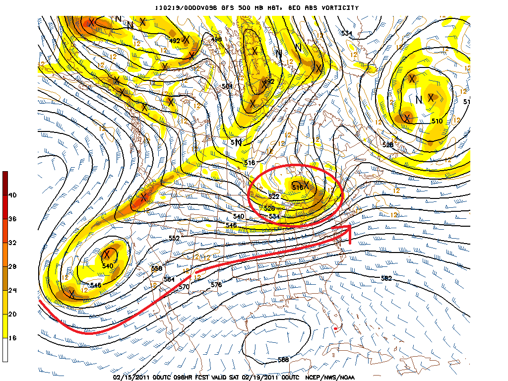
Beyond Saturday, strong cold air remains in place for sunday. The next major system is the one circled above. It should move into the midwest sunday and then start to slide east, affecting the North Country sometime on tuesday. Right now I think it will pass along the NY/PA border and bring a strip of snow to the North Country Tues/Wed. I’ll keep you updated.
10 Comments
Leave a Reply
|
|||
| Home |





Colin_extreme
wrote on February 15th, 2011 at 10:42 amThanks for the straight dope LH. I can’t stand how pumped the crappy TV weather guy is about the warm up.
Greg
wrote on February 15th, 2011 at 10:48 amthank you LH!
looking forward to the FIS corporate retreat this weekend! we’ll still have fun
Doremite
wrote on February 15th, 2011 at 10:59 amGreat update. Would be nice to see some white stuff fall on Jay Saturday. Thinking may get pretty crusty with warm up + even light rain followed by the temp drop. Will likely need 6″+ to bring back the fun factor… then refreshed back to mid winter Tues/Wed. Keep hope alive.
Roger Kappe
wrote on February 15th, 2011 at 11:39 amI for one will not appreciate any warm air until I’m sitting under the sun on the rocks at the buckets.. Thanks for the update LH. Everyone all giddy about the warm weather was starting to get me depressed ;-)
webfoot
wrote on February 15th, 2011 at 2:05 pmPraying Burke does not get to crusty. Thanks for the straight dope.
powhounddd
wrote on February 15th, 2011 at 8:29 pmJust a little warm bump, it’s still good, it’s still good….
oh, that flow is straight outta Hudson’s Bay, friend!
Lionel Hutz
wrote on February 16th, 2011 at 8:13 amWhatever. Compton has gangsters, HudsonBay has polar bears. Both don’t like me.
Big Wave Dave
wrote on February 16th, 2011 at 10:50 amburke has been sublime lately. glades still fresh how many days after dumps?
booo crust.
Peter
wrote on February 17th, 2011 at 2:39 pmLH, any thoughts on the upslope potential for Friday->Saturday now that we’re a bit closer to the weekend.
thinking about goals for the weekend. Am I aiming for spots that ski well with “dust on crust”, or am I still chuting for powder lines?
thanks
pw
joshg
wrote on February 18th, 2011 at 12:46 pmWhat’s the verdict? Its ugly out there…any hope on the backside?