WED EVENING UPDATE: Full Size Candy Bars!! Winter Weather Event “Able”
You know what’s awesome? Houses that give out full size candy bars on Halloween. It’s like the homeowners’ are saying to the rest of neighborhood: “Paul did well this year, and you know what, here’s our middle finger. We’re better than the rest of you.” As kid, you gotta love it and respect the game. You know what ELSE is awesome? Snow storms on Halloween weekend. Oh wait…what?..Fall snow? Un-possible! (Oh and WTF is with Winter Weather Event “Able”)
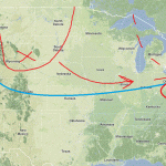
By thursday, a frontal boundary will be draped across the country (arched blue line) in the approx. position shown above. At the same time a shortwave trough (red U shape) will swing down from the central plains/high plains with a strong vort max (red x). As the trough and the associated vort max reaches the great lakes region ohio valley, it will begin to interact with the frontal boundary, with downstream upper level divergence ahead of the vort max, the interaction with the frontal boundary has the potential to spark cyclogenesis. Actually let me rephrase that. It WILL spark some cyclogenesis. How much, and where that system winds up is really the question. You’ll note that in the image above I’d noted where I think the trough and vort max will exist come later on thursday (dotted red line). That’s a great position for moderatly strong N/E fall storm.
With that position, you sorta have two options.
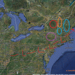
1: the trough to could tilt westward with height (called negatively tilting) and really start to wrap up a powerful storm. Said storm would track back towards the NW and bring some really interesting weather to the ADK and Northern Greens. (It could also track WAY west as storms have done this year and bring rains…less likely). We’d see the low tracking in that vertical red oval.
2: The trough never really tilts and spins off a moderate strength low that slides along the frontal boundary. This would bring the heavist weather to Southern VT as the low picks up juice from the ocean. The low would track right along in the horizontal red oval.
So ok…computer guidance has plotted BOTH solutions. Recently all major computer guidance has hinted at the second option. However much this fall has verified warmer and further n/w than modeled. With that as a trend you have to take seriously the first option. Coincedently, this was the preferred solution as far back as 10 days ago- giving a little more weight to that option.
With that said, then here is a first idea:

I see the low not really wrapping up that tightly but following a track that is further to the n/w than modeled. I think this brings the best chances for snows to places like Southern VT and NH. (Circled in blue in case you don’t know where Southern VT is). I’m not going to talk totals or elevations YET but this event could produce nicely schussable snow here. Next, in northern VT I think the we see snow, in lesser amounts, but to a lower elevation. The ADK follows a similar pattern but remains on the edge with lesser amounts. The catskills are tricky…they could get a very solid snow or they could get mixed out rain and precip. Right now, I’ll lean towards mixed to snow.
We’ll talk totals later in the week and preserve ourselves the right to adjust this towards solution 1 above as necessary. Oh and just keep your eyes on sunday as well. There is the potential for coastal development.
WEDNESDAY AM UPDATE:
Model consensus is on solution 1 outlined above. At this time my thinking is that the a series of weak impulses will ride that frontal boundary starting early thursday am and culminating in a large impulse that scoots along late thursday night and early friday am. Real accumulating snows (greater than dusting to an inch) will reach about as far north as Kmart with the majority of heavy snow confined to the higher terrain of the Catskills, and Berks. There we could see upwards of 6 inches across the higher terrain with the chance for 8+ across the very tips of the catskills – assuming the thermal profile stays as modeled.
Now – as for the mention of Sunday….there will be costal development…but it will likely be too far s/e to affect “ski country.” Thinking however that PHL, NYC and the Cap see some flurries out of this and maybe even a few inches. Cool. I guess.
WEDNESDAY PM UPDATE:
So ok…Lets say this…it’s going to snow, starting tomorrow morning, across the high ground of the catskills, berks and southern VT. Simple as that. By late thursday, we’ll see snows maxing out in the 3-6 inches across this region. The highest snow totals will occur in southern VT where it’s possible the very highest terrain creeps into the 8 inch range if everything breaks right. Will it? Yea. I’ll say it does. The orographic flow is good for the southern VT mountains and we’ve been trending a toucher cooler than guidance for the last few days. So why not.
13 Comments
Leave a Reply
|
|||
| Home |


ml
wrote on October 24th, 2011 at 2:05 pmF^CK YEAH!!!!!
MadPatSki
wrote on October 24th, 2011 at 2:28 pmThanks Lionel. Everything seems up in the air right now.
Josh
wrote on October 24th, 2011 at 3:14 pmIt’s up in the air now, but the question is how much of it will be down on the ground this week.
heh heh…
MadPatSki
wrote on October 24th, 2011 at 5:24 pmJosh…
1) how much will fall
2) what will fall
3) where it will fall
4) and when
I’m seeing and reading a bunch of scenario all over the map (pun intended again). Some happy, some not so happy scenarios. And to make things more interesting, add the possibility of a possible snowmaking temps with an even more or less probable spinning bullwheel race to declare a winner. If so, will someone open in October and who will it be?
You have to be flexible and available to go when and where it happens. Now if I can only get some work done before I can take off. :(
rangerjake
wrote on October 24th, 2011 at 4:16 pmFuck candy, this feels like christmas. And the possibility for a damn sweet present. I am getting itchy.
Harvey44
wrote on October 24th, 2011 at 4:51 pmI closed on my house a couple days before Halloween. I had no clue about Halloween and when I got home the place was crawling with kids. Ran to the store and bought the only candy left – the full size snickers. I was quite popular. I’m ok with either option = #winteriscoming.
Aaron
wrote on October 24th, 2011 at 6:13 pmAny thoughts on how much -won’t- stick due to a saturated, unfrozen ground type surface? Or do we have the potential to get enough that it won’t matter?
I have a feeling Sunday River will go for it this weekend. Anyone else in for the trip if they do?
MadPatSki
wrote on October 24th, 2011 at 6:35 pmSR is one of many options for me right now. I’ll know more when white things fall in place and accumulate.
bushman
wrote on October 24th, 2011 at 8:35 pmbetter borrow your brother’s/sister’s/cousin’s board/skis cause if there is enough flakeage (FIS term)to slide/schuss it’s gonna get scratched down to the gravel as you go, leaving p-tex etc. Hey, great to get pumped, but climb up to get a couple inches of base, whatever, cause when you hit dirt, the skis/boards stop, you don’t. By Vets day weekend 11/10-12 is when I’ll try old boards out. Keep us posted LH, you never know.
iskihard
wrote on October 24th, 2011 at 9:51 pmi’m sure kmart will push to open early if they get the temps. If this storm hits right the masses will be headed to the north ridge triple and i’ll be over at hico. Even if it’s only a couple of turns. i love october skiing. Thanks for the weather LH
Adam Klein
wrote on October 27th, 2011 at 12:43 pmYour post is featured in my new short film out today on Vimeo depicting the dreams of snow we all experince this time of the year. Check it out and please share!
Adam Klein
wrote on October 27th, 2011 at 12:44 pmthe link didnt seam to go through on my last post, check it out
http://vimeo.com/31202872
powhounddd
wrote on October 27th, 2011 at 10:35 pmdiggin the almost realtime Candy Bars FIS reference at the beginning. Fun edit.