It Gonna Snow (and keep snowing…and keep snowing…Friday Update)
Well that was nice….looks like more is on the way
Tomorrow, a wave of low pressure is going to develop to our southeast. It will move up the coast and stay to our southeast. It isn’t going to be as potent as the previous storm though. As the upper trough swings through on saturday it should push some light precip into the region. 2-4 inch type stuff beginning later saturday afternoon.
Then in the wake of the system- well as part of the system rotating into nova scotia – a nothwest flow will develop at the same time cold upper air moves in. This will spark orographic precip along the Spine and the Northern ADK. The flow looks blocked a bit and its possible the best snow will be confined to the western slopes of the spine. However with any northwest wind wind transport will move a bunch of that snow up and over the spine anywhere lacking trees.
Overall I think we’re looking at weekend totals in the ADK and VT in the 4-8 range (of pretty fluffy snow).
So yea…it’s going to keep snowing.
Long term it’s looking cold and active.
Nice!!
End Update
Here is the forecast:
SNOW.
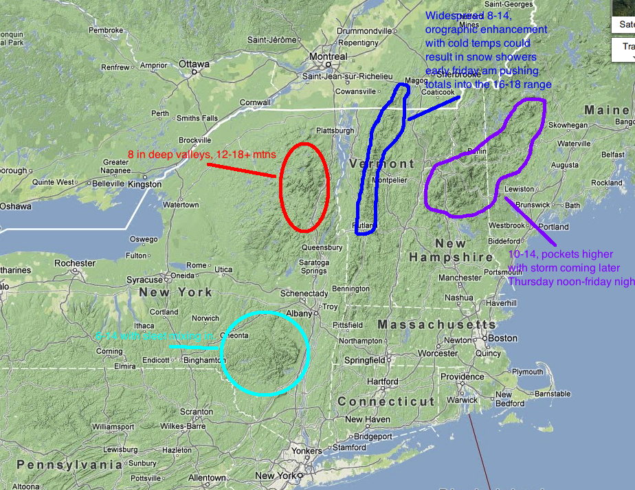
Totals thru Friday 12/28/12
In the meantime, why not enjoy some FIS stoke from the nights before Christmas
THURSDAY 10:00 AM UPDATE
First- I’d like to note that I’ve bolded the dates for which this map applies. Some of you- esp. those along the eastern side of the Spine of VT might think this storm is a little juuuxt. It’s not your time yet.
Currently the storm center is to our southeast with a center of low pressure right around Montauk point (a PRIMO Location). That is giving our winds a strong easterly component right now. With that east wind, areas on the east side of the Spine will see less then perfect snow conditions. Areas west of the spine on the other hand will see GREAT snow making conditions. Also, given the location of the low, the prime dynamics (locations of deformation zones/confluence of the triple jet structure/frontogenesis…yada yada yada) for heavy synoptic snow will be over the ADK. Another 10-14 inches+ are possible in the High Peaks over the next 24hrs with storm totals of 18-30 inches likely.
Now the tricky part comes along the Green Spine. At some point this afternoon the winds will shift around to the North and then Northwest. At the same time significantly colder air will move in aloft. This combined with lingering low level moisture should spart robust upslope snow showers. If the numbers are to be believed we’ll see upwards of 6-8 inches of pretty fluffy champlain dust once the winds shift around. So depending on how that segment of the storm plays out, the Spine could do VERY WELL. Nothing beats an chasing down a pint of dense storm snow with a shot of 4% fluff. Still watching this closely however. Some model skew-ts show a slight capping inversion which may inhibit the orographic uplift.
So yea…that’s the update for now. I’ll try to take a closer look at the Whites and Maine later. Though based on how this is going I think a widespread 10-18 is a reasonable forecast.
18 Comments
Leave a Reply
|
|||
| Home |


Lane
wrote on December 26th, 2012 at 7:52 amYes, YES, YES!
Holly
wrote on December 26th, 2012 at 8:18 amAnd the winner is….ADKs!!
Harvey44
wrote on December 26th, 2012 at 7:51 pmDig it!
mattcolton
wrote on December 26th, 2012 at 11:13 amback home in tully, ny for the holidays and it looks like we might get a foot. hopefully make it to smugglers for a day.
Ultrajamzilla
wrote on December 26th, 2012 at 12:24 pmThank you Lionel! It seems as though NH will finally get some. Damn VT and ME bogarting all the pow-pow.
Enjoy your turns e’rybody.
arewolfe
wrote on December 26th, 2012 at 1:44 pmThanks, Lionel. Any thoughts on Magic? R***, snow, mixing?
Lionel Hutz
wrote on December 26th, 2012 at 1:57 pmlittle bit might mix in but overall anywhere in VT is going to see mosly frozen stuff- at least that’s per the overwhelming model consensus.
Ben
wrote on December 26th, 2012 at 2:37 pmAny thoughts on NWS’ predicted 20-32″ for the Cottonwoods by Friday?
Lionel Hutz
wrote on December 26th, 2012 at 6:59 pmTweeted about that this morning. It is 100% reasonable. I’d 25-75 go with a 12-24 but certainly higher amts are possible up there.
Should have done a national snowmap.
Sorry Ben
Roger
wrote on December 26th, 2012 at 5:34 pmA-f’n-men.
Lane
wrote on December 26th, 2012 at 7:57 pmI am beyond stoked for this storm. Alarm set for 5:30AM, excuse to call out of work all set, skis in car. LET’S ROCK!
MadPatSki
wrote on December 26th, 2012 at 11:52 pmDaughter ski team (not in US) choose a great to start it’s Christmas Camp. We might get 6″ out of this. Great start to the season if you add it to the one foot plus of snow on the Apocalypse snow event.
Holly
wrote on December 27th, 2012 at 7:12 amSpotter report: 12+ already in KEENE VALLEY NY. Can’t even imagine what is in the peaks. We are getting hammered!
Ella
wrote on July 20th, 2016 at 8:50 amPlay inimtoarfve for me, Mr. internet writer.
Big Wave Dave
wrote on December 27th, 2012 at 4:43 pmdid the Whites snowshadow the NEK on this storm? my BC routes are seemingly not getting the love they need… hope it stays strong through the AM.
bushman
wrote on December 27th, 2012 at 7:35 pmJP had 10″ by 10 AM, projecting 20″ by 10 PM; most not accessed due to high winds, but tomorrow it’s all fair game.. kudos to VT DOT for clearing roads in NEK and 242 esp.
mtl_ripper
wrote on December 29th, 2012 at 7:45 pmsnow boner.