Late Word: You might get some flakes where it matters: 12/5-12/6
So I’m sorry for the late update but I was busy doing dirty unspeakable things with concordance. Dirty, dirty things….
What was I talking about…oh right…flakes where it matters.
OK- so i’ve been pretty much a pessimist about this weekend’s storm. Why? ‘Cause the overall weather pattern doesn’t give me a reason not to be.
However, this little storm that really should just shut the F up and slide off the coast doesn’t want to do that. It it keeps wanting to be a dick about things and make it snow places you might want to ski. Not saying it will snow in places where you should ski- just in places that people have skied before.
So here’s the story:
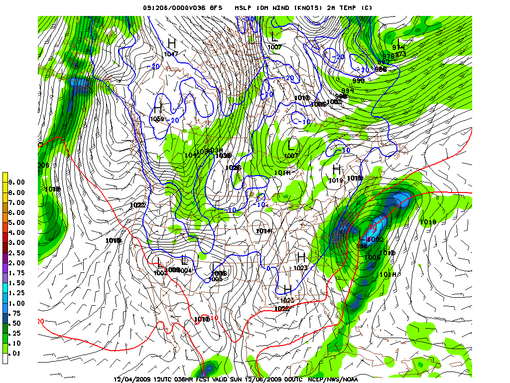
A low pressure system that’s currently tracking along the gulf coast, where it’s bringing snow to houston (yea- how about that crap!) will swing up along the edge of a trough that spins down through smoky mountains/southern apps. (You may have read about this possiblity a week ago here: http://www.famousinternetskiers.com/long-range-thoughts-are-we-in-for-a-deep-freeze/#more-1825 )
So as the storm swings along on its merry ride to nowhere it will spin itself up and start to move out over the ocean along the NC coast and then up the EC. At this point the MD hills look to pick up a few inches from this system as to do the smoky mountains (8 up high) and the mountains of southern VA.
Not too much question about that, nor is that really interesting. Unless you want to ski at Gatlinburg (GO VOLS! ROCKY TOP! WHOOO!) that is. The interesting part is that by sat. afternoon, after a cold rain has been falling in the poconos, philly and SJ, cold air will begin to work into the region.
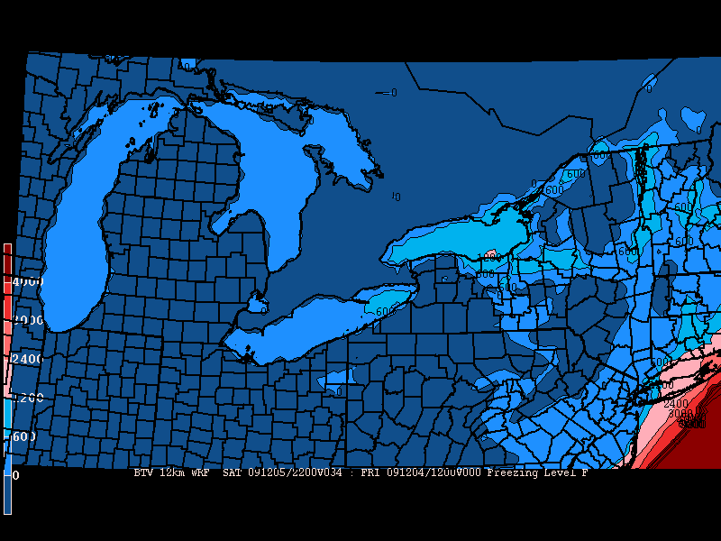
By sat. night the freezing levels will have fallen to under 500ft. Which with dynamic cooling from the snow falling should mean that all precip falls as snow and maybe even sticks.

You can see that by sat. night a fair amount of precip will be spreading into the northern philly/southern Pocono region

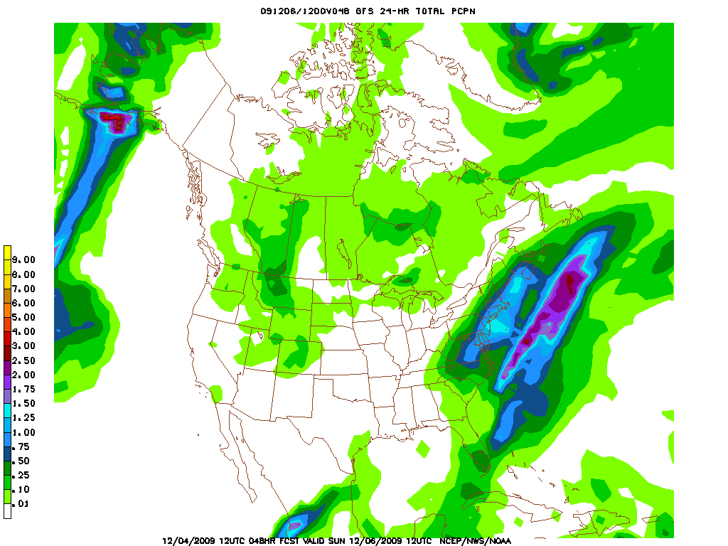
By the time the system pulls the precip offshore sunday AM there could be up to 1 inch of liquid over terrian that is…how shall I say…skiable:

With marginal temps I don’t see this being a very “fluffy” snow BUT hell…it’s better than nothing.
So what are we talking for totals.
If the track holds as predicted – and with 36 hours to go that’s a HUGE if – i think we are looking at 4-5 inches of wet snow max in the poconos, somewhere in the hills just south and west could get like 6 I suppose. The catskills too could be looking at like 3-4 but would benefit from a westward shift.
I’ll keep you updated.
17 Comments
Leave a Reply
|
|||
| Home |


ml242
wrote on December 4th, 2009 at 5:26 pmthat’s pretty good news…
could you put some odds on this becoming a full blown noreaster and dropping 2-4 feet across the greens and whites?
Jonathan Shefftz
wrote on December 4th, 2009 at 5:41 pmWAMC wx fx was just talking about snow for the Berkshires.
Checking the NOAA point forecast, looks like the possibility of some nordic skiing by Sunday morning in Western Mass and Southern Vermont. Notchview and Prospect sit on high plateaus on the Route 9 highways of their respective states.
Here are the respective weather forecast — these two ski areas can often wring skiable snow out of the most meager forecasts:
http://forecast.weather.gov/MapClick.php?CityName=Windsor&state=MA&site=ALY&textField1=42.5136&textField2=-73.0435&e=0
http://forecast.weather.gov/MapClick.php?CityName=Woodford&state=VT&site=ALY&textField1=42.8803&textField2=-73.08&e=0
Lionel Hutz
wrote on December 4th, 2009 at 6:10 pmHey! Welcom Jon…I just read your review of Avy Beacons over at Wild Snow…great write up. Glad to see you have found us over at FIS. W/R/T those to ski areas..I think you could see up to 4 inches there when all is said and done. While cooler temps aren’t my concern for those locations, the westward creep of the heaviest precip is. That far north and W is cutting it close IMO but not so far that a little snow isn’t reasonable. Further in eastern mass there could be up to 5-6 inches by sunday afternoon.
byates1
wrote on December 4th, 2009 at 6:23 pmmaybe some ashfault assault on g lock road is in order sunday. sheffey, you can go for total distance covered in feet instead of height. with some real snow up there, you could really post up a number! think of the tr possibilities!! (….today i covered 6 billion horizontal feet!) etc..
Jonathan Shefftz
wrote on December 4th, 2009 at 7:36 pmLionel, yes, I’ve even found you guys on the slopes — I’ve skied with Sam a couple times, Allen once, and Greg once. Sam and Greg have a few pics of me up here from the few fall ski days we’ve managed to pull off during this limited preseason. Many thanks for all the weather beta!
Byates1, distance is always in kilometers, at least for the hard-core nordic racers. (Like those young women you saw roller skiing the other week.) Their trip reports are often really scary. Usually starts off with something like, “we did such and such a drill for so many k,” and I think, oh, sounds like a good workout for the day. But then it goes on with, “then we switched to such and such a focus for so many more k.” Repeat. Many times. The New England rando race scene would be pretty intense if these guys ever discover Dynafits. Though reminds me of a comment a ski partner recently made that, “triathlons are for people who are afraid of fun,” so the continuous downhill segments in rando races might be long of a break from rigorous aerobic workouts for the dedicated nordic types.
byates1
wrote on December 4th, 2009 at 10:19 pmi like it( the comparisons)
a funny quote re; tri’s..
“try a real sport, who want’s to be the best at exercising?”
Greg
wrote on December 4th, 2009 at 10:49 pmThat first map came from the “Keys to the Kingdom”, eh LH?
Are you guys arguing in here? I can’t even tell with all this metric talk… speak American!
Jonathan Shefftz
wrote on December 4th, 2009 at 11:10 pmBob’s gotten so much in the habit lately of sending me text messages from his Crackberry that he can’t write in any other format.
byates1
wrote on December 4th, 2009 at 11:57 pmhey… i resemble that remark
(grumble grumble)
i just found out i’m staying with 8 euro club hot ski team chicks at chinmey pond this march,
so yeah, i’m rad
out.
byates1
wrote on December 4th, 2009 at 11:59 pm.. and for duck’s sake,
get a real phone..
Snowdancer
wrote on December 5th, 2009 at 2:09 amCould next Wednesday’s storm be the big one we have been waiting for? Snow-forecast is predicting almost 18 inches for Killington.
powhounddd
wrote on December 5th, 2009 at 10:37 amyes yes bring it Ullr
Greg
wrote on December 5th, 2009 at 10:39 amsorry byates1: too many @ work readers.
@ snowdancer… sure hoping! do thingy dances now
byates1
wrote on December 5th, 2009 at 6:39 pm@ greg- no prob, will keep it reasonably civil going forward
snowing decently here in the capital region, headin out for some apres work xc now
Greg
wrote on December 5th, 2009 at 7:57 pmwell… no need to keep it civil… just don’t use any duckin’ swears… or else i’ll edit them.
bushman
wrote on December 6th, 2009 at 9:38 amFYI heading up to Jay Friday. By then should me more than just jet triple running; expect Haynes trail (mellower than Jet) an some stuff (read “glades” around Tramside/lower mountain to be skieable with expected dustings all this week; no rain Weds night, please; Jay Cloud? Come in, please? Figure 4-6″ on top of what they have, maybe t-side metro will run along with T-bar and jet chair. And no crowds, they’re out shopping. will report after visit..
Greg
wrote on December 6th, 2009 at 4:11 pmI’m keeping my fingers crossed for you bushman! I can see Jay getting away with almost no NCP (non crystallized precipitation)… but we’ll have to see what the actually happpens. Do report back!
In fact, we’re currently developing a twitter-type system wherein users could make on the spot reports of conditions from a mobile device, and have them displayed in a special section of the site. In the meantime, we’ll have to make do with comments.