Long Range Thoughts: Sniffing out a Mid-Month Storm (Updated 1/16/10: Chances for significant snowfall increasing for So. VT)
First let me chip the ice off my keyboard…ok…that’s done. Now on to more important things…namely the weather (and lunch). All and all it’s pretty quiet around these parts. Excluding this historic cold snap, (only two other times in the past 50 years with the latest being 1977 as the -AO been this negative for this long) there hasn’t been much in the way of storms. However, I see that changing around MLK weekend.
1/16/10 Update: Central to So. VT looks like it is best positioned to see significant snowfall
Currently, this system is located just off the Gulf Coast and a strong comma shape has developed.
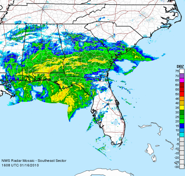
Importantly this is a warm system at this time and will bring rain to much of the coast as it tracks northeastward. The surface low center should track just inland until roughly around Cape May when it will emerge out over the ocean. At this point the system should deepen just enough to turn the winds over the mountains to a northern flow.
While Arctic air will not be present to be drawn in, sufficiently cool air should filter in over a swath from central pa, through the catskills and on into the berkshires, southern VT and southern NH.
The Nam has, since yesterday depicted this rather well:
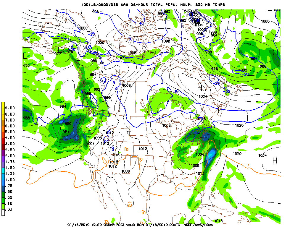
Sunday Night at 10pm you can see the system developing off the NJ coast with a cool strip of air at 5k ft through central pa into NH:
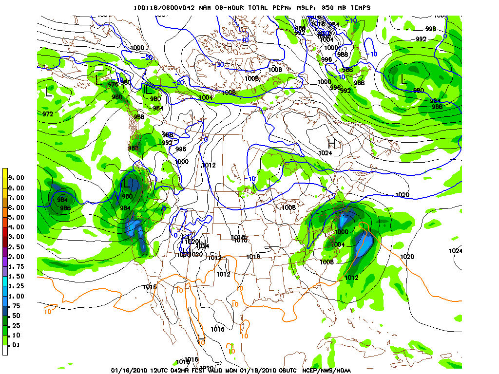
Six hours later, the storm has tracked to Long Island and should be spreading moderate precip over the catskills, Berks and So. VT.
By Monday morning, the storm remains rather deep and is located just off of Cape Cod. This is a very good track of So. VT and NH.
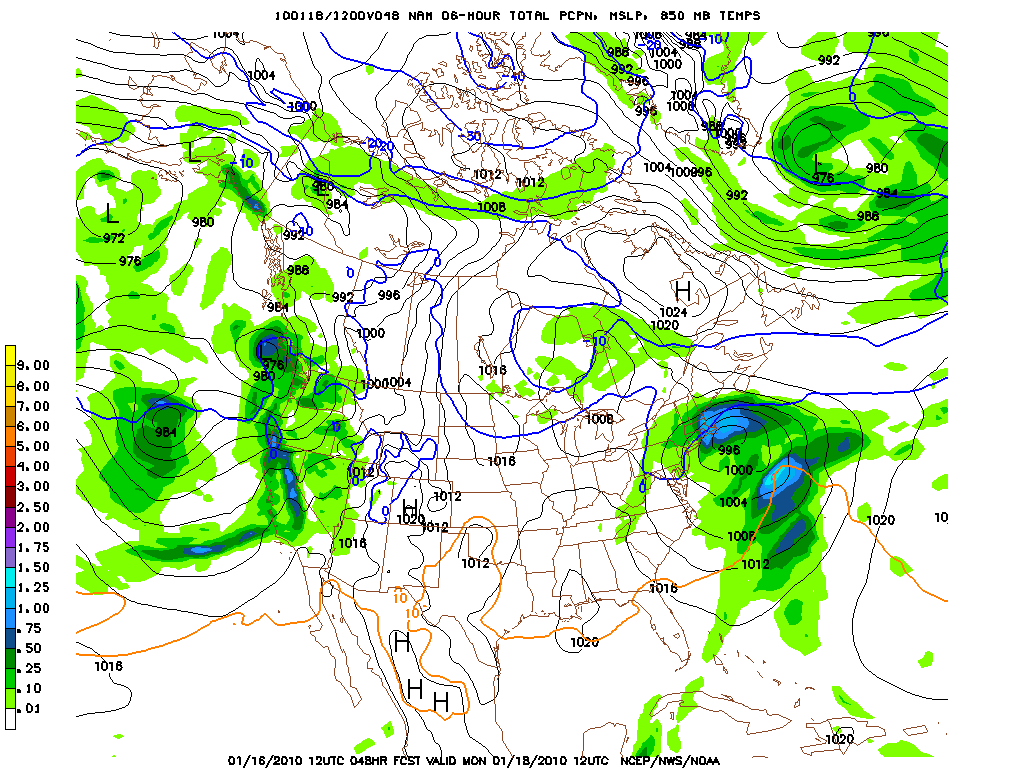
Notably when looking at the 2m temps and freezing levels we see actually rather low freezing levels given the moderate temperatures prior the storm. I suspect lower elevation temperatures will hover in the low 30’s while temps around 5k will be roughly 27-33 (-1 C or so). This, while not being the best snow set up reminds me of a fall storm where lower elevations get a few inches of wet snow, while higher elevations get significantly more snow.
All in all, I don’t see a ton of Theta-e or Omega with this system so there isn’t going to be a ton of vertical motion creating heavy snow bands. Rather I see a nice moderate to significant snowfall for the Catskills, Berkshires, So. VT (Magic looks good here) and on into NH.
Best amounts will prob. be somewhere in Western Mass or So. VT with best totals reaching 8 or so inches. There certainly will be the danger of some sleet mixing in because of the moderate temperatures but we’ll just have to watch for that as it develops.
Enjoy!
1/15/10 Update
Currently a deep lcluster of convection is developing along the Texas Gulf Coast. You can cleary see the developing low at the center of the big white cluster off the texas coast in the Sat. Image below:
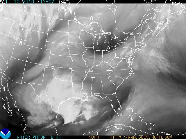
Now, if you have been reading this blog you will not be surprised that this system has developed. Two weeks ago we talked about how as this pattern changed a storm would develop and here we are. As we monitored the develops of the weather patterns, you also would have read how the models are having a very hard time determining the path of this system and the extent of cold air in place for the system. Well this STILL hasn’t changed.
See we are leaving a pattern where the northern stream of the jet was dipped WAY south. Any energy emerging from the S. West would have ample cold air. Now the Northern stream has receeded and mild air is erroding all that arctic air we had in place. Thus any system we have would likely be a warm system.
However, as the storm travels north as weak back door cold front seems to hang around upstate NY, Mass, NH, and ME. This cool air reminds me of a late march system of even an october system where marginally cool air will interact with a warm core coastal system. With snow on the ground, evaporative cooling and temps at 5k hovering around 0c there is the chance for the hills of So. VT and Mass to actually get snow out of this system. Actually, with the storm looking to head a little more noth and less east as the steering flow pattern suggests, I’d even say No. VT, NH and even upstate NY have an outside shot at seeing snow snow from this system.
How much? Tough to say…very tough to say. I’d say 4-6 is in range of the cold air holds and track stays…but we’re still a ways away given the difficult (from a forecasting standpoing) weather pattern we are in.
I’ll keep you all posted.
Jan. 12 update
Models are having a hard time with the phasing of this system. Latest data confirms that a large complex of energy and convection will develop in the Texas gulf coast over the weekend. However at the same time the CONUS overall pattern will be transition to a more zonal flow from the west ridge/east trough pattern we have been in. This makes it hard for models and me to really predict where this storm will go and how cold it will be.
We really have three options for sunday to tues time frame (the event is a little behind timing wise then where we thought it would be…)
1. A warm storm that slides east out to sea over the NC coast.
2. A cooler storm that brings snows to the southern apps and slides off the delmarva coast
3. A cooler storm that spreads snow about as far north as the catskills as the center of low pressure slides more n/ne.
I can’t rule out any of the possibilities right now but will stay on top of this for you all.
Outside of the storm, the weather is pretty quite the rest of this week. Light disturbance will bring some spotty snow showers to upstate NY and VT today. Some more organized snow showers will occur on friday as a weak front pushes through the area. Doesn’t lookt wet but with decent RH values the WRF spits out 1-3 for the greens and ‘dacks which makes sense.
After that we’ll see a moderation in temps as the CONUS undergoes a pattern change.
Jan. 11 update
So as we get closer to this time frame my confidence is rising that the east coast will see a storm. Currently there is a large ridge over the west coast. An impulse in the middle of the weak will undercut that ridge and work to break it down. As the impulse slides s/e into texas it will interact with the highly juiced of STJ. The dry shortwave will feed off of the STJ and deep cyclogenesis will occur of the NOLA area.
From there the path of the system is unclear. Using only teleconnections is difficult. The fact that the AO, PNA and NAO are all changing at the same time make predicting a track hard. The system could head west into the great lakes or up into the Southeast.
I feel pretty good that the system will not head west of the apps. The real question to me is whether the system phases with the northern jet and swings north bringing heavy snow to NY/Mass/VT/NH OR whether the system follows the pattern from the 12/18-12/20 storm. This winter I’ve leaned towards suppressed systems because that’s what this el nino should favor and that’s what we have seen.
Right now however it’s too early to make a call.
(Other than the storm, this week will be another mid winter week. Light tues/wed time perdiod with the passage of a front should bring some enhanced snow showers to the mountains. 1-3 inches would be a fair guess.)
OLDER BLABBERING
Currently, the AO is extremely negative, we have a strong Greenland block/-NAO in effect and the Pacific-North American ridge is strong positive. What this all adds up to is a deep cold pattern. The pattern is so strong it’s suppressed a strong el nino’s effect on the STJ (Subtropical Jet) shutting off our supply of juicy moisture laden energy. Even Debbie wasn’t a STJ enhanced monster. If you remember she didn’t blow up until she interacted with maritime air west of Maine. Had she not retrograded we would have been SOL.
For us to get a big storm, the pattern needs to relax and allow the STJ and western energy to flow back into the country and feed off all the dry arctic air with interaction between the two taking place along the Gulf/SE coast.
As a note: the current storm that the news is all ga-ga about is merely an arctic jet system that will blow itself out over the southern apps. (10-18 possible at snowshoe if you care). Not really helpful for the north country.
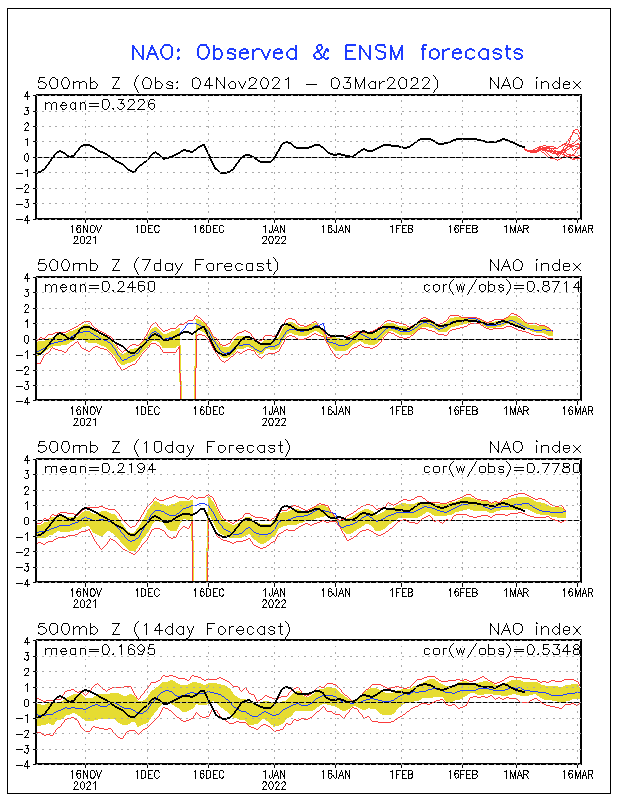
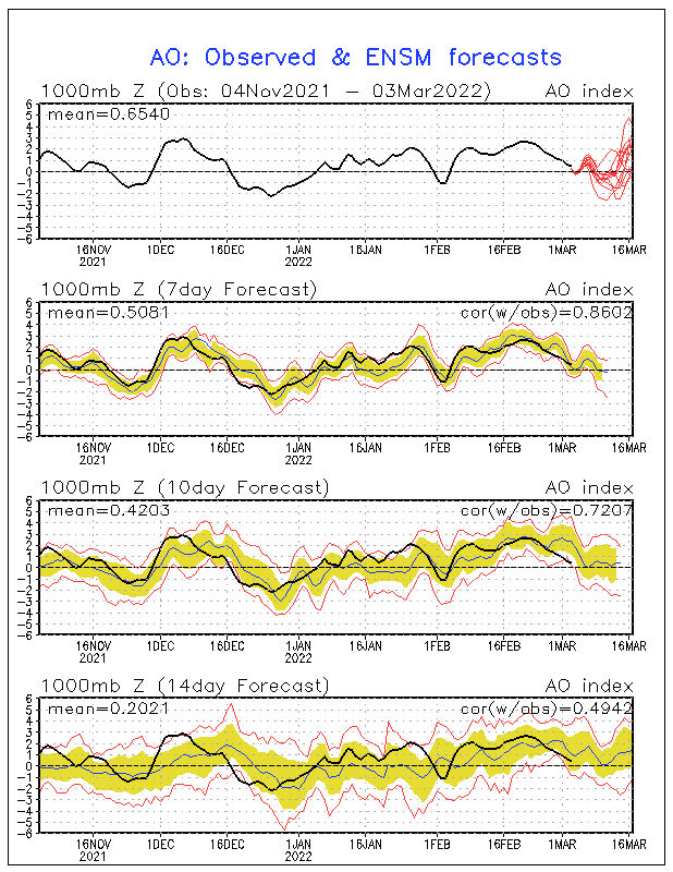
Looking at the Long Range teleconnection ensemble forecasts it appears that sometime after the 16th- say between the 17th and 19th we should see the pattern relax.
The NAO:
The AO
The PNA:
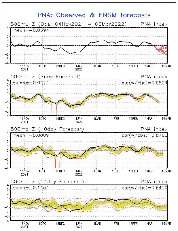
With the teleconnections all slated to change at roughly the same time we have to look at that time frame for possible storm development.
Looking at the Long Range Models we see several items of note:
First we see the ECMF ensemble mean height anomaly:
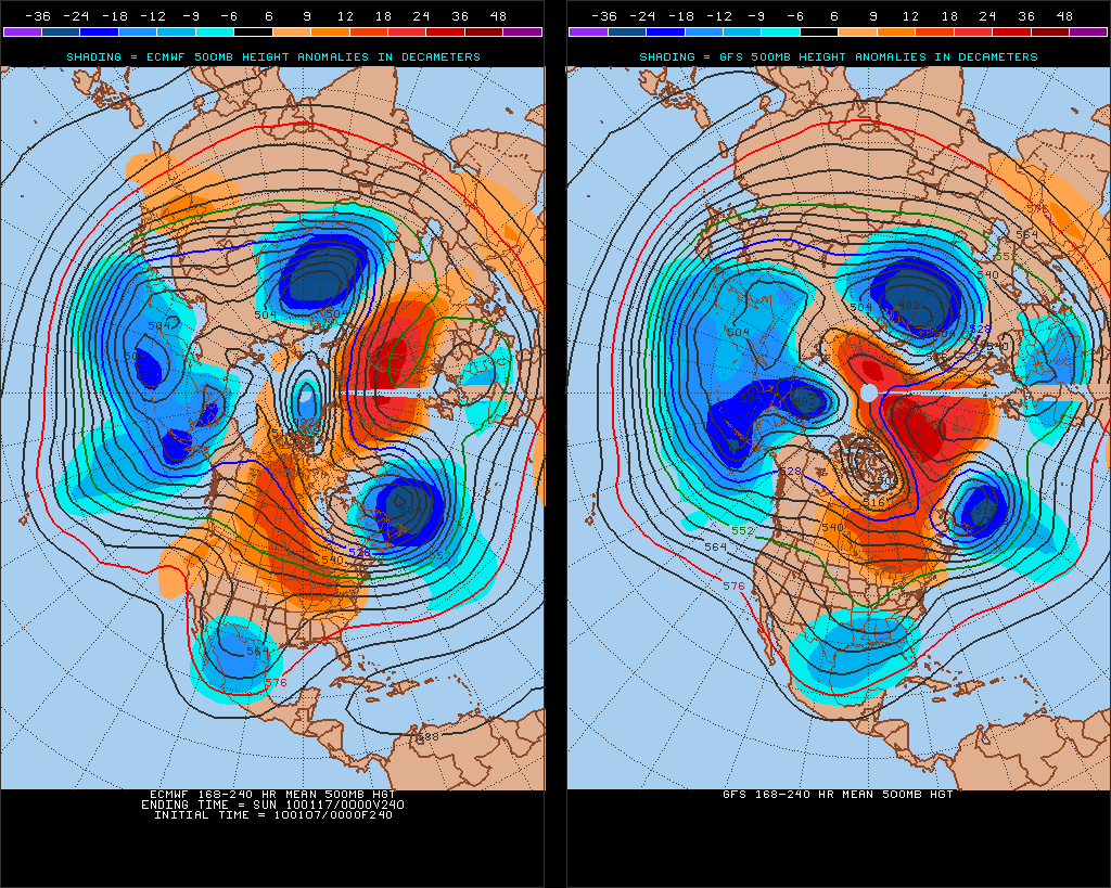
A quick glance shows both the EC and the GFS support suppressed heights in the Gulf states just prior to MLK. These lower heights support storm formation in the Gulf regions.
Once we get within 10 days, it’s worth peaking at the GFS. Yesterday’s 12z run is right on the 24o hr mark. here is what it showed:
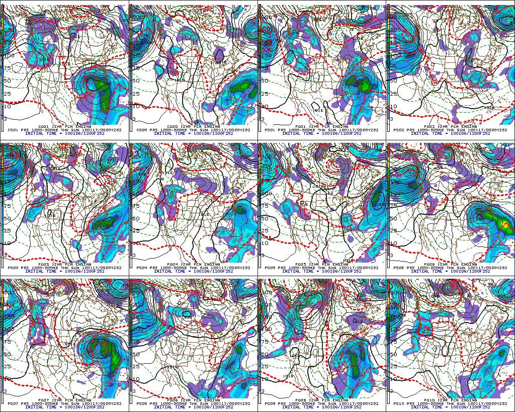
Certainly the LR ensembles support the hypothesis that storm formation is possible beginning at around 240hr.
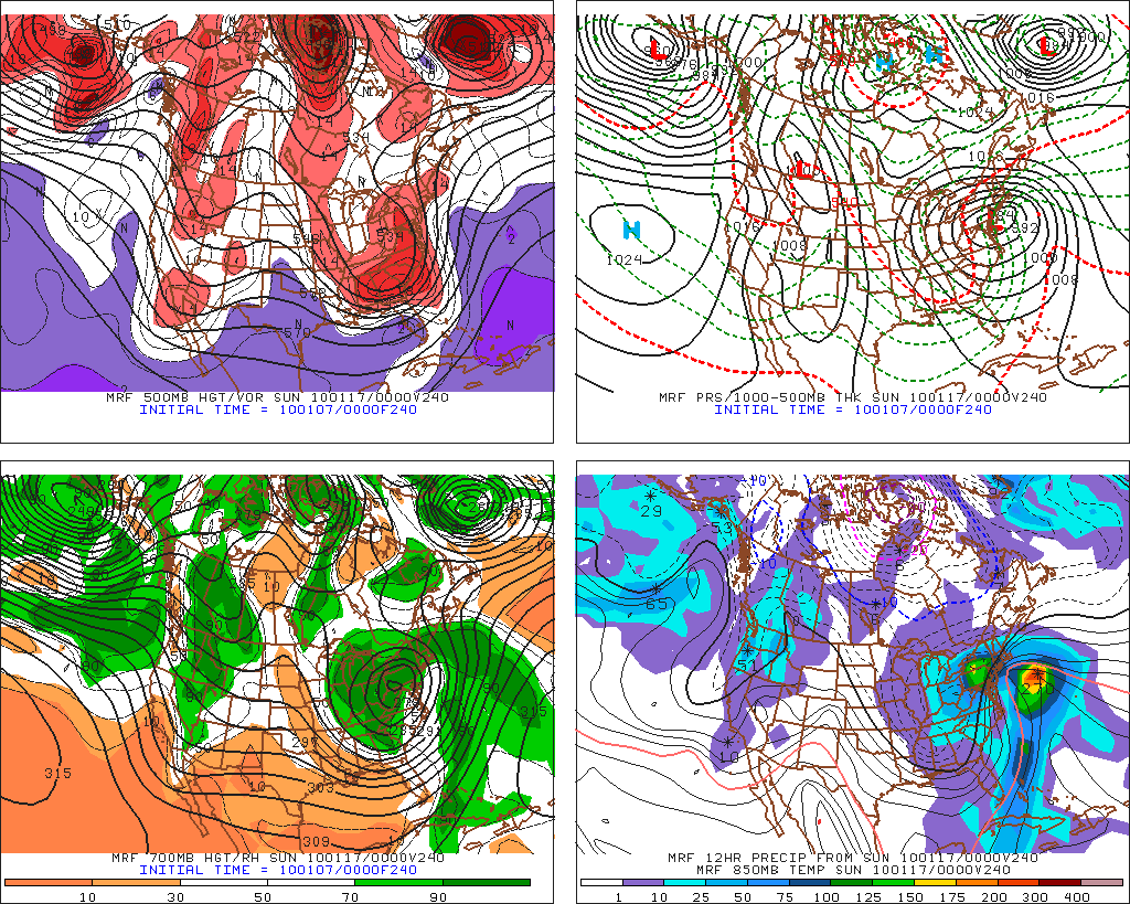
Today we see a similar solution with the 0z Operational GFS:
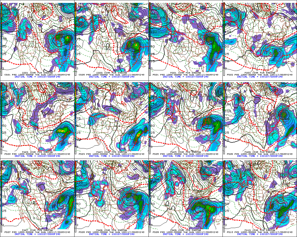
And there is fairly good LR ensemble mean support:
So after all of that – you might ask: What do I take away from this? Or as my man in KV said : What’s the cliff notes version?
Simple: Watch out around MLK weekend for a storm. It appears at this time that conditions will be favorable for eastern US storm development.
9 Comments
Leave a Reply
|
|||
| Home |




K_C
wrote on January 7th, 2010 at 3:37 pmThanks LH! Greg gets back east on the 14th – hopefully just before a nice storm blows through.
powhounddd
wrote on January 7th, 2010 at 3:58 pmAwesome analysis and then the 2-liner cliff notes, just classic. Thanks again!
Im_a_crappy_skier
wrote on January 8th, 2010 at 1:55 pmI’m a weather-tard and I love reading your analysis, thx.
byates1
wrote on January 9th, 2010 at 2:18 ami was at okemo today, amazing conditions
lift lines were not bad, we were in the trees all day. i was trying out my new helmet cam, should have footage up later. some snow snakes, but not bad
saw a few people on bro’s, called out for change, but it was windy. thought i saw a few mags, but hard to tell.
may be at killington tomorrow. squads, naxo’s, 1st gen axon’s(black flexon tongue) black pants, ’07 cloudveil troller gloves(tan), white giro fuse helmet, red patagonia mixmaster shell(i’ll have a blue vest on underneath, also patagonia), smith goggles(lime green lens), black bd bandit pack(should have a blue camelback tube sticking out), should have 1st gen bd traverse poles(reg. baskets, not powder)
if you see me ask for change, hope to see some of you up there..
Chris Baker
wrote on January 10th, 2010 at 7:40 pmWhat was the other year? 1977 and ????
Evan
wrote on January 13th, 2010 at 12:45 pmWhat’s up with the rest of the month? I’m hearing not so happy things from Josh Fox at MRG…please say it isn’t so. Does Feb still look good?
Josh
wrote on January 14th, 2010 at 4:55 pm^^^ Yeah, I’d like to know the same… early reports were promising for a great February. Please please please???
Greg
wrote on January 15th, 2010 at 12:12 pmthanks for the update Lionel
St. Bear
wrote on January 15th, 2010 at 1:32 pm/looks at Liftopia receipt for $29 Magic tickets
//swoons