UPDATE
I love weather. I really really do. However I recognize that exciting weather rarely comes without consequences. So I wanted to be wrong. I wanted Sandy to miss wide right. By hundreds of miles. She didn’t. As I type this Sandy is nearing landfall along the southern NJ coast. Major coastal flooding has taken place and will continue to do so through tonights high tide. Sandy is a metorlogical wonder but a damaging bitch. Marvel at her but regret her at the same time. I feel terrible for the coastal destruction taking place in N.J. right now but very lucky to wtiness this storm live as a weather forecaster.
There is also a sense of pride at getting stuff right. You forecast knowing that deep down, it’s all just a guess. A big giant guess. There is always a chance you are a gonna get punked. So when you see this:
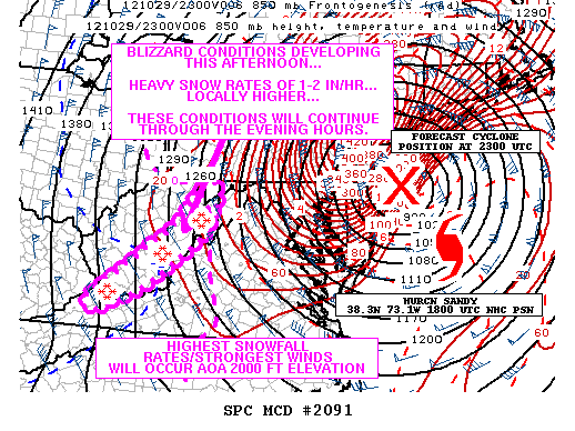
you just gotta smile and bank it for the next time you get one wrong.
End Update
I’m not going to hype this event. No need. As it looks right now, an extremley powerful storm will impact the Northeast early next week. Up until today, I felt that there were two divergent solutions. Now, I believe the major operational weather models are converging on a reasonable solution.
Let me set the stage with the players.
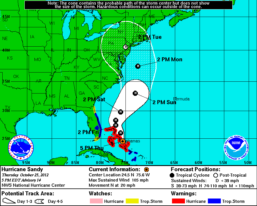
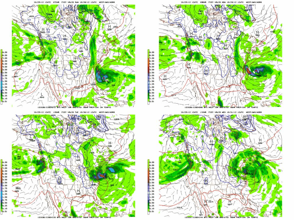
First we have Hurricane Sandy. Sandy currently is just north of the Bahammas with max sustained winds of 105mph. She will move north over the next 72 hours to a position roughly parallel to the NC/SC border:
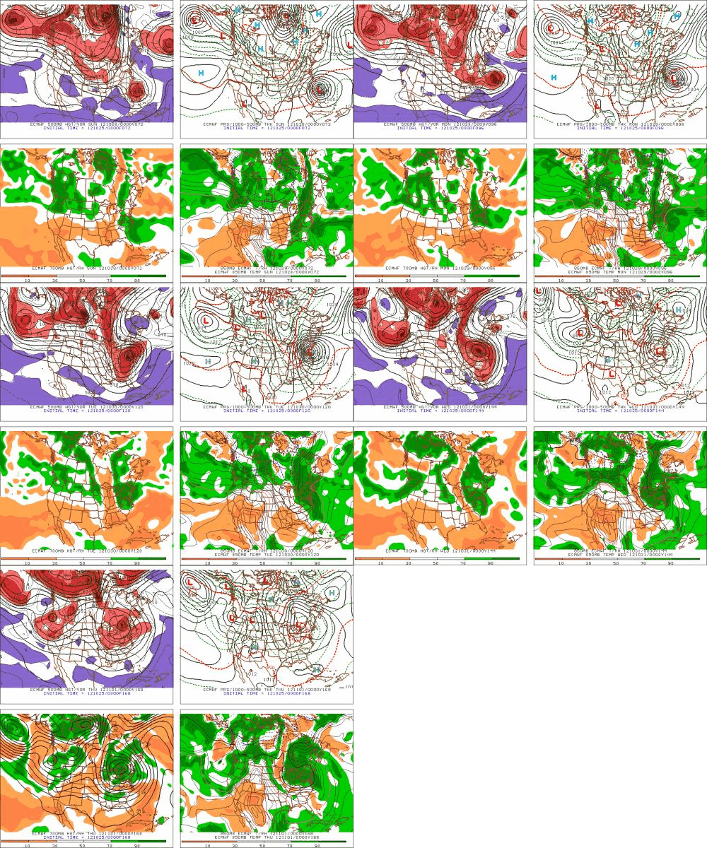
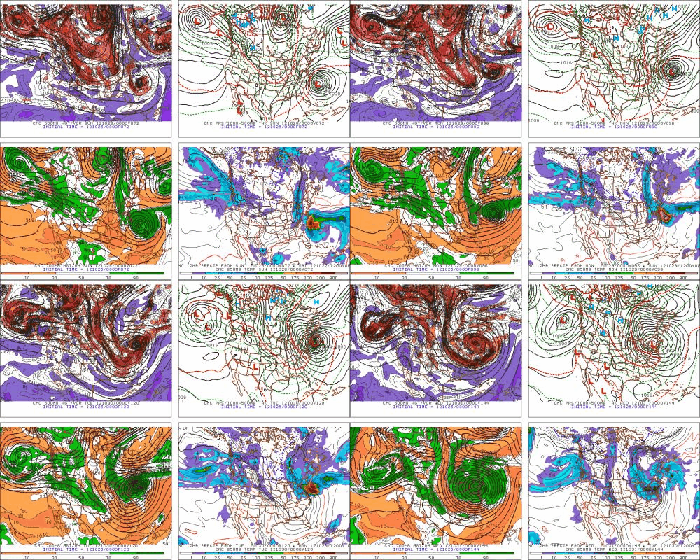
At the same time a cold trough will be digging into the eastern half the united states. (You can see that in the gifs below).
It’s how these two pieces interact that gets so interesting. As air rounds the bottom of a trough, its spin relative to the earth picks up. When the air exits that curve, the spin decreases. Like a figure skater who spreads her arms out to slow her spin, the air mass spreads out. This is divergence. When it occurs it promotes uplift and cyclogensis. Tropical systems exist on a similar (but more complex) pattern of uplift, mass divergence and subsistance. If you can get the two system to link up, or “phase”, something special happens. Rarely does it actually happen that a fully developed, STILL tropical low, gets caught in a cold trough. That’s “Perfect Storm” shit right there. The results are explosive.
Well until today, the models were having a hard time resolving the solutions. The Euro wanted to phase Sandy and the trough very early and slam the combined storm right into the Delmarva. The GFS wanted to track Sandy to the east, and spawn a second phased low through the combination of a NORLUN trough and the upper level divergence from the trough. I favored this solution over the too simple Euro solution.
Well now, today, I think we have a resolution.
Look:
Looking at these models it is clear to me that, an extremely powerful storm is going to make landfall somewhere between NJ, LI and Conn. late Monday/early Tuesday. Before that happens, the entire Northeast will experience bands of rain with embedded thunderstorms as the massive system phases, expands and draws moisture in off the ocean. “Sandy” will make landfall with high winds, and heavy winds. The worst effects will be felt in an arc from Conn. through westchescter county NY and then on into central pa. Further north we’ll see steady rain, heavy at times with winds gusting pretty high. Will it be Irene. unlikely. I just don’t see THAT much rain falling that quickly. But it could be close in some spots:
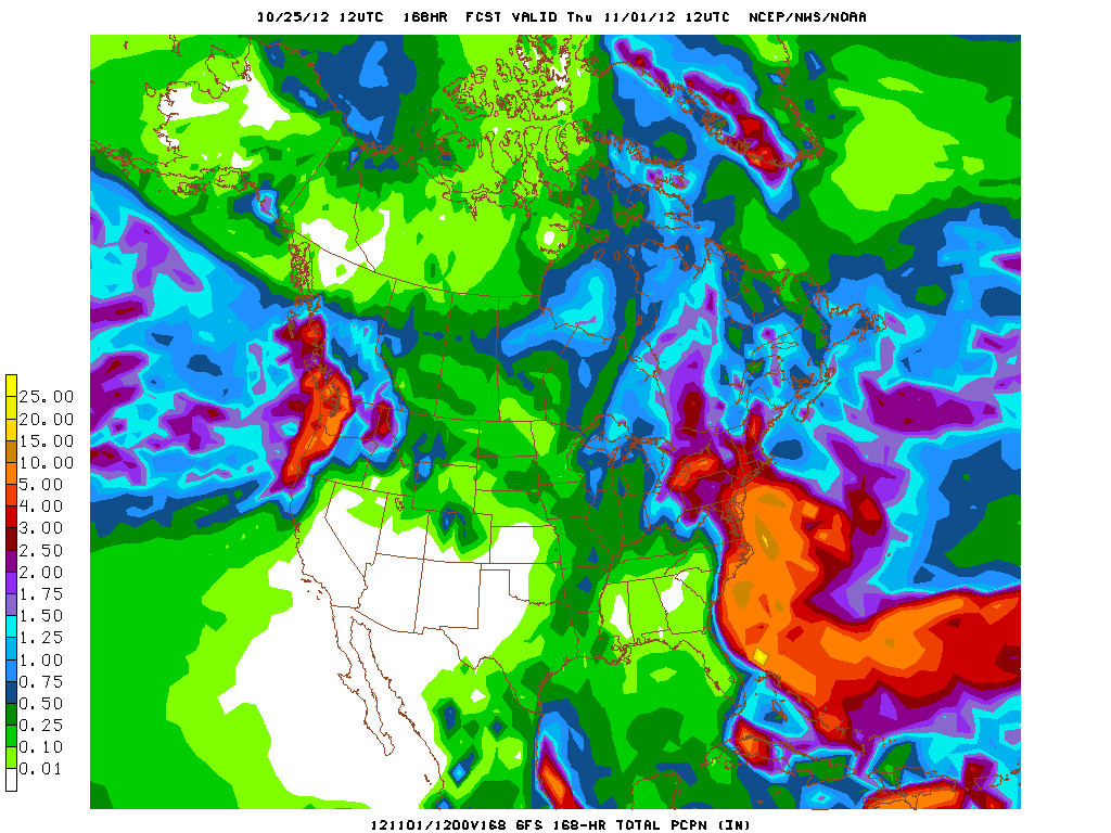
Once Sandy makes landfalls, she’ll linger as vertically stacked low. She’ll be cut off for a day or two from the prevailing flow and just sit and spin overtop of us. This will produce another few inches of rain and she’ll start to wrap cold air around her core and decay further. She then slowly moves out, clearing the area by Thursday of next week.
As for snow, well that’s going to be part of this system as well. As of now it looks like the hills of southwestern PA, Western MD and esp. West VA will get a tremendous snowfall. Totals in these areas could approach 4 feet with regular 2-3 foot totals reported when this all wraps up later next week. Also the occluded system drifts out on Wednesday, she has the potential to put a pretty good orogrpahic snow down along the ADK and Greens. But that’s really a week away- and I’ll update that part later.
For now, focus on the fact that rare, powerful and impressive storm is very likely on Monday.
19 Comments
Leave a Reply
|
|||
| Home |



mtl_ripper / powhounddd
wrote on October 25th, 2012 at 6:13 pmHoly moly. Hope for positive snow impacts for skiers and no tragedy for everyone else. :/
I <3 weather.
sbr
wrote on October 25th, 2012 at 6:16 pmWow. You will need to come up with a memorable name for this one!
Snicklefritz
wrote on October 26th, 2012 at 12:15 pmFRANKENSTORM DUN DUN DUUNNNNNNNN
Harvey44
wrote on October 25th, 2012 at 6:37 pmThanks Lionel.
jason
wrote on October 25th, 2012 at 8:42 pm2-4′ of snow! with a 546thickness and marginal 850’s
also there isn’t a cold pool to the north?
and the greens and dack’s too? where is the cold air? no disrespect i just don’t see it
MSLP 1000 – 500mb : 156
../GemPakTier/MagGemPakImages/gfs/20121025/18/gfs_namer_156_1000_500_thick_s.gif
MadPatSki
wrote on October 27th, 2012 at 3:28 pmQuote from Jason on the NYSB: Oct 23, 2012; 7:45pm
“sorry to squash this, but the latest run has this system a million miles off the coast.. “
Anonymous
wrote on October 29th, 2012 at 12:12 pmdon’t think lionel says anything is set in stone for the greens or white mountain
also, apears its snowing in WV pretty hard. guess the cold air was there
Anonymous
wrote on October 30th, 2012 at 5:39 pmhahaha… do you see it now?
http://l3.yimg.com/bt/api/res/1.2/XTxOQArFUWBq.tli8wtrgQ–/YXBwaWQ9eW5ld3M7Zmk9aW5zZXQ7aD0zMTY7cT04NTt3PTUxMg–/http://media.zenfs.com/en_us/News/ap_webfeeds/c8c6de139782791e1f0f6a7067009419.jpg
cliffy
wrote on October 25th, 2012 at 9:12 pmIf that did indeed happen (4′ in Pennsultucky), how weird would it be for that to be top snowfall state of early season for whole US!!
whitewoodchuck
wrote on October 25th, 2012 at 10:45 pmThanks LH!
bushman
wrote on October 25th, 2012 at 11:00 pmfigure power outages and river surges ala Irene. thanks for the heads-up LH
UltimateSubzero
wrote on October 26th, 2012 at 7:54 pmHmm., thanks LH, like yourself I’ve been observing this developing storm…. Is it wrong that I’m considering a drive from VT – West Virginia???
Would others be interested as well, is the question at hand?
Vermont representing in W.V.?…
MadPatSki
wrote on October 27th, 2012 at 3:39 pmYes, I’ve been looking at it. Based on what I know now, I know where I would like to be and when (WV on Tues-Wed). I know I’m not alone. The question is the logistic in getting there.
You can contact via my blog. madpatski.wordpress.com
UltimateSubzero
wrote on November 2nd, 2012 at 12:14 pmUpdates!
So I got to Snowshoe, WV Resort [with sits @ the Top of the Hill, very unique]… Befriended some of the Staff over there, did 6 tours in 3 days = It Was Awesome for early season Fluff [sure Tuesday could have dropped much more, as initially postulated [other weather ref.] BUT for early / heavy wet, with with compact it was really fun.
Mind you I got in Sunday afternoon. Saw the flakes really pick up Monday, especially. Very windy as well up top, but once descent came = no real worries….
Only on Wednesday skiing in the “Western Territory,” did I meet up with others, several snowboarders / skiers… Trail rattings = waaaaY over rated on difficult, the blacks, and the double blacks I skied = would only be VT blues, but that is another discussion altogether. Pitch was the best on the “Western Territory” side of the Mtn. I hit that throughout the day Wednesday… Tuesday I was on the otherside of the Mtn.
Estimates = 18-28+ [w/o wind blown]
With wind blown = More than above…. But also some sections in fall line with “only” 4-8 inches…
Tuesday, it did snow, but Sandy moved a bit to far West @ that point for some Major Bands to continue to hit the area… That day could have been another 20+ new inches, but I believe the closer result was 8 ish inches… And, at times the flakes were really “wet.”
Jon Williams (pa freeskier)
wrote on October 28th, 2012 at 8:43 pmI’ll be 15mins from Wisp, WV from thurs to sunday I have good feeling the goods are still gonna be available then. I love the sound of skins in early November in the PA/WV region, get some!!!
Jon Williams
wrote on October 29th, 2012 at 9:55 amjust heard on CNN that parts of WV above 2500 feet could see up to 60 inches!!!!! Those guys in Atlanta are no Lionel Hutz but that’s bold and down right gee golly neat predictions…beacons in WV? Be safe out there
I'm a crappy skier
wrote on October 29th, 2012 at 4:58 amDudes, If your not there (i.e., WV) “now” your not getting there! Can’t drive in a hurricane unless your ride is a sherman tank. (gas milage sux in those too!)
Hoping poer stays on and may my WV brothers and sisters shussh the S@#$t out of this thing!
I'm a crappy skier
wrote on October 29th, 2012 at 4:59 ampoer = power (for my non-dyslexic brothers)