Next Up…More Pow? (updated with UT content and maybe next week pow)
Well, another midweek comes and goes, another midweek upslope pow event comes and goes. So what’s next right? Well how about some more snow? Would you all like that?
So, remember in Nemo when I talked about how two lows interacted with the final product being a super strong coastal low? Wait, no, you don’t? Whatever, I remember and take my word- it happened. Well a similar situation could unfold this weekend albeit with a weaker coastal low developing.
Lets take a look at a few model solutions to see what I’m talking about.
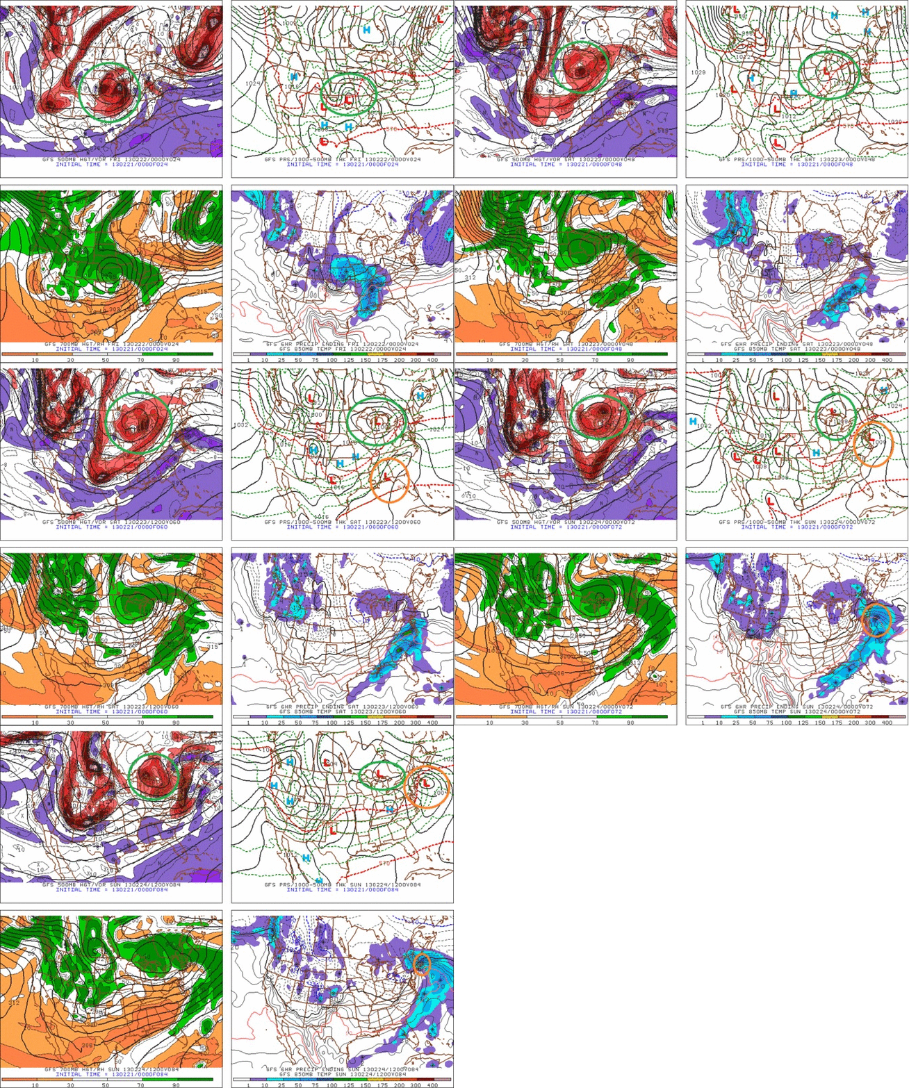
Below is the GFS. I’ve annotated the two low structure I’m talking about. You can see the “northern” low deepen in the center of the country and move towards the Great Lakes. At about the time it reaches Western NY, a low from the south is developing along a cold front assocaited with the northern low. (Orange cirlce). That low then moves up the coast, deepens, and draws energy away from the northern low. The coastal low reaches the NY bight late saturday/early sunday and takes a East/Northeast track over Cape Cod on Sunday and moves out into the Gulf of Maine.
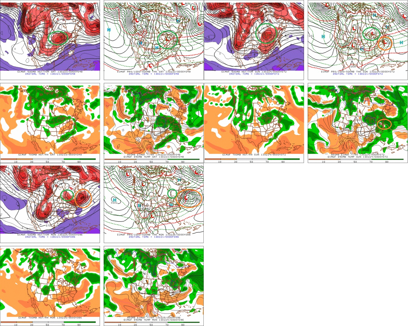
The European Model is very similar. Makes a slightly stronger coastal low, and weakens the northern low, as comapred to the GFS but overall…it’s about the same.
Now, some of you have seen talk about these storms already. Not to be a dick, but any predictions at this point as to what kinda snow this event is going to make, and where it is going to make it. Especially, when such a prediction uses a “clown” map, is just silly. We’re a ways off from this event unfolding and so measured, analytic terms are appropriate.
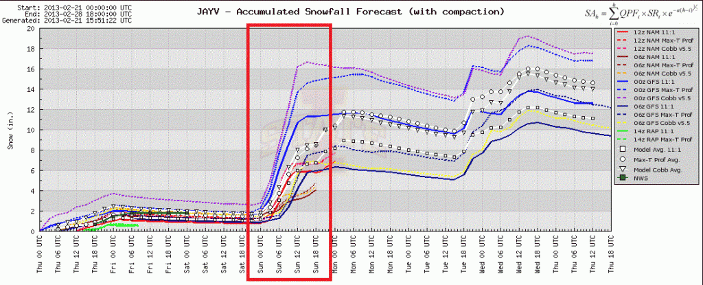
For now, the models are spitting out pretty heavy totals for Northern VT.
Here is a sample for Jay Peak:
Looks awesome right?
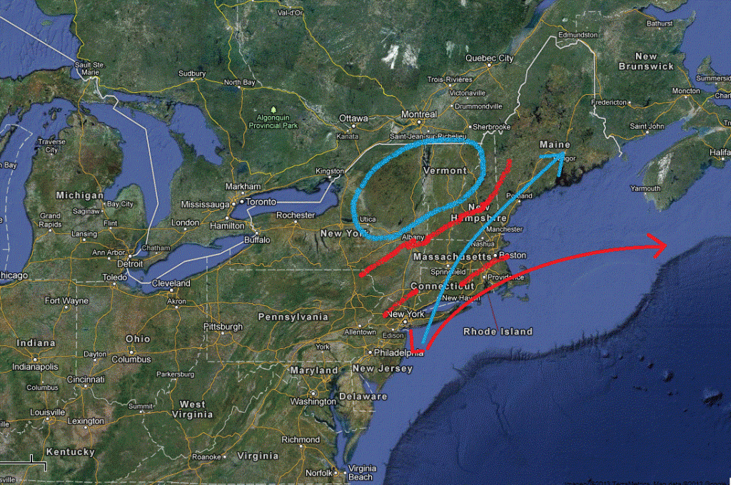
Well I don’t believe it. I think (oh and as I type this the 12z model suite comes out supporting my point) that this storm is going track further s/e than previously modeled. So lets pull up a diagram to make this point. In the image below the red arrow is generally the modeled track.
When mid-latitude cyclones move up the east coast of the U.S. the dynamics of the triple jet structure associate with them creates a pocket of heavy snow to the N/W of the low. Normally that area doesn’t extend much more than 50 or 100 miles to the N/W from the track. Beyond that, atmospheric dynamics favor a sharp cutoff of precip. So when a model throws off a ton of precip way northwest of a coastal low, I’m skeptical.
For real pow to impact the ADK and VT, I’d like to see at least a track matching the one outlined in blue. Now, that’s not saying we can’t get a good pow from the red track. In fact we can. More likely it will come as did the best pow in Nemo. From an interaction with the “northern” low’s warm front and moisture from the southern low. That’s tricky to forecast and right now I don’t see it. Nor do I see how, if the low tracks as modeled, (and accounting for today’s slight eastward trend) that we get a major dump out of this. I’m of course leaving my forecast open to adjustment. For now I’m going with something like 6-10 in the ADK and Nor. VT, Whites and N/W Maine. Possibly more in the Catskills, Berks (way more) and again, So. NH.
So I guess you’ll just have to deal with the 1-2 feet of new upslope snow…Life’s so hard.
UPDATE, FRIDAY AM (Pre-poo)
So first, an update on the weekend storm. We’re still in line with my basic thinking outlined above. Coastal low takes a fairly flat east/ne track. That’s going to put the heaviest snow band, Sat night thru Sunday, in the Catskills (mixing), Mass, and Southern NH. North in VT and the #ADK I think about 3-7 inches of snow will fall. Some models are showing an elevated tongue of moisture affecting the champlain valley. Not sure I believe a) that idea and b) that such moisture will not actually fall on the spine. So, lets say there is a chance (under 50% that some areas in the Central spine- Kmart thru Sugarbush) pick up 8-10 inches of snow.
Now we turn to Utah. On Saturday, a classic cold UT cold front will hit the Wasatch. With good moisture through the 700mb level, plenty of lift, and nice cold temps this has all the makings of a very good pow. Timing wise I think some light snow will move in Friday – late afternoon- with the heaviest snow coming saturday thru saturday night. The GSL is pretty warm, and the air incoming is fairly cold. So if the winds line up right, and it looks like they might late saturday, early sunday am, I think we might even get a little lake effect action. Over all I think this is a quick 10-20+ type storm for LCC/BCC and maybe 6-10 elsewhere.
Lastly, I’m VERY VERY interested in next week for the N/E. I like the idea of a cut-off stationary low parking over the N/E. It just makes sense. It’s happened several times before, particularly in years with an ENSO signature similar to this one. It also commonly happens this time of year. So I see NO reason why the consistent model solutions aren’t 100% viable. Will they play out. I dunno. But I’m watching it closely.
End Update
–Lionel.
18 Comments
Leave a Reply
|
|||
| Home |





NutmegCharlie
wrote on February 21st, 2013 at 11:51 amLove the forecasting intel and analysis. I have to say that I’m pretty frosted (pun intended) about the fact that you didn’t give any heads up about the dump that Jay and Stowe got last night! I have the sorry misfortune to be from CT, and while I can and do ditch work on a powder day, I need to know about it in enough time to get there! I know, waaa waaa waaa, but please, share the love!
Adrian
wrote on February 21st, 2013 at 12:48 pmDude, even though Lionel didn’t give any heads up, this upslope event wasn’t exactly a secret. Open your eyes and ears and pay attention next time.
Adrian
wrote on February 21st, 2013 at 12:49 pmAnd actually, now that I think about it, there was talk of the upslope from FIS on Facebook and probably Twitter as well…
Nick
wrote on February 21st, 2013 at 12:53 pmYeah, was well-publicized on lionel’s twitter:
https://twitter.com/lionelhutzskis
Also check the NWS Burlington forecast discussion:
http://forecast.weather.gov/product.php?site=NWS&issuedby=BTV&product=AFD
and facebook:
http://www.facebook.com/photo.php?fbid=442360442502529&set=a.187811151290794.45023.161924887212754&type=1&relevant_count=1
Lionel Hutz
wrote on February 21st, 2013 at 3:45 pmChuck-
Sorry for not doing a full FIS post but I def. wrote about it several times on our facebook page and on my twitter page. I know it’s tough to keep up at times and I’m sorry about that. But sometimes I only have a moment (I’ve got a real job) to write a forecast and so facebook and twitter provide the best vehicles for that. Thanks for reading though and here’s my tip for you. The next two weekends should not be spent in Conn.
JASON
wrote on February 21st, 2013 at 6:51 pmFlatlander…Stay in CT!
Sandman
wrote on February 22nd, 2013 at 10:01 amIf you dont have the resourcefulness to AT THE VERY LEAST, follow LH on twitter,FB (as he has mentioned countless times), then STFU!!
Peter Wadsworth
wrote on February 21st, 2013 at 4:10 pmnice write up, but needs moar bullets.
cliffy
wrote on February 21st, 2013 at 6:52 pmthanks lionel – heading up to N spine in am as per your spot on guidance – caught on to your twitter stuff this year and never lacking in info of where/when to find pow…
ut pow.
wrote on February 21st, 2013 at 8:01 pmLionel
Whats your thoughts on the wasatch front, for this upcomm
ing week.
Greg
wrote on February 22nd, 2013 at 5:03 amHow much for Stowe?!
NutmegCharlie
wrote on February 22nd, 2013 at 9:09 amI hate Twitter, and the first thing I saw on FB was the satellite image with a note about looking good for Jay…I guess I didn’t interpret the tea leaves correctly/didn’t want to pull the trigger on that sketchy info alone.
Lionel I totally respect the job you do, and that this is a part time thing. You do an awesome job, and I’ve come to rely on your updates (when I see them in time) as to where the real deal snow is going to happen. I just wish I could make a real living in VT, or that I had the mad stacks of cash it would cost to drive up to VT every week!
Nick
wrote on February 22nd, 2013 at 10:18 amIf you’re on FB, the NWS is a good resource to follow.
NWS Burlington:
http://www.facebook.com/US.NationalWeatherService.Burlington.gov
NWS Albany:
http://www.facebook.com/US.NationalWeatherService.Albany.gov
They both do a fairly good job of detailing forecasts
christian
wrote on February 22nd, 2013 at 11:09 amLionel:
Please tell me what time to set my alarm, what to eat for breakfast, which undies to wear, how many trekking poles to bring and which tracks to follow.
HOW DO I GET POW IF THE INTERNET IS DOWN!?!?!?!?!?!?!?!?!?
Lionel Hutz
wrote on February 22nd, 2013 at 11:42 amA) 5:49 am, snooze (10min), groggy ball scratch (4min), less groggy ass scratch (3min), arise at 6:06.
B) Groats and a snickers bar.
C) None. Skip the pants all together. Just a nice long gortex shell.
D) 1. Bring a katana to compliment in case of line-poaching.
Ultrajamzilla
wrote on February 22nd, 2013 at 11:21 amYou the man Lionel! Thanks for the updates, and for the nod to NH.
We in the Granite State appreciate it.
natron
wrote on February 23rd, 2013 at 10:22 pmhow much for newfoundland? werd iz thatz the new found land (o’pow)
the places we mainers will go for goood sliding, fml.
Pablo
wrote on February 24th, 2013 at 8:46 amI’m interested in this next system. Can’t wait for the update. Already told my boss that i’m going to be extremely sick thursday/friday…..?!?