Potential for First Flakes in the Northeast!!!
No shit. I’m hesitant to post this because I don’t want to be that guy…you know the guy that screams “IT’S GONNA PUKE” as soon as any weather model hints at a snowflake. However, I feel like the possiblity of seeing a real, honest coating of snow above the higher terrain of the central ‘dacks and greens can’t pass without at least a heads up to ya’ll. So with the usual disclaimer that I’m talking about the weather which does what it wants…here we go:
While, last weeks cold snap was nice, it’s larger and angrier brother is on the way next week and with it’s arrival, comes the chance for the first snow showers of the season across the higher terrain of the Adirondacks and Green mountains.
Here’s the Scoop:
Over the weekend a large and strong low pressure system will develop over the northern plains/great lakes. With it will come a strong cold front that will bring very high winds and raw weather across the great lakes as the weekend ends and the week begins.
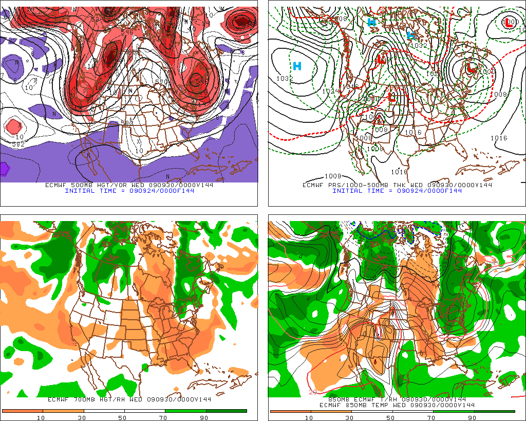
By monday, the low will track north of the border, and drag the cold front across the north country. As the low becomes vertically stacked and stable it will sit and spin in northeastern quebec. The flow of air around the low will direct air from the northwest over the lakes and then east over the adk and the greens. You can see that in the four panel map below.
As night falls on tuesday, the low will have brought enough cool air into the region to bring higher elevation temps down to below 0c.
At the same time the wind will remain steady from the east, bringing moist air into the cooler air.
Were this the winter time we would be talking about a pretty decent snow event. But it’s not winter. So what does all this add up to you ask? Maybe a coating above 3000 ft. Just enough to make us all remember how much we love winter; How much we love starting into the woods when the fresh snow sparkles as the rising sun’s rays filter down through the trees and nothing besides you moves in the below freezing woods as all you hear is the sound of your skis swishing through the snow with the rest of woods’ creatures tucked away from the harsh cold.
Importantly it’s worth noting that the shear will be pretty low so moisture will be able to travel pretty far. Places like Kmart could def see some of this action (if I can call it that).
The Euro (another forecast model) is less agreesive with this and generally doesn’t depict the same chance for snow showers. Whatever. We’ll see what goes down.
Euro not as aggressive:
2 Comments
Leave a Reply
|
|||
| Home |


ml242
wrote on September 24th, 2009 at 6:02 pmIT’S GOING TO PUKE!!!!!!!!!!!!!!!!!!!!!!!
laseranimal
wrote on September 24th, 2009 at 6:36 pmAAAHHHHHHHHH
Auto Road Sufferfest!!!