Potential for New Year’s Day Nor’easter (updated 1/3/10)
By the time the ball drops, you look for somebody to kiss and start to regret having the filet, you’ll know whether Crystal or Andre will be the bottle to pop open. (If you don’t know what Andre is well – good for you. You obviously never tried to hold it down the next morning on a crosstown bus.) Why? Because as the year winds down a significant winter storm will be winding up.
1/3/10 UPDATE
Well…I knew the spine of the greens would see significant snow but…holy fack…30+ in Burlington….wow. That was plain freakish. The dynamics which caused such intense snow in BTV were almost impossible to predict. I’m just happy that my call of 18 didn’t bust!
With that said…next few days the wind is going to be whipping but the ADK, Greens will still be good. Also, check out the catskills if you can’t get north. All day snow was established in the catskill region (I know- I drove thu it!) and with some lake enhancement it could be quite good.
wow…on this storm. I hope you cats are all out there getting some. This thing was an overachiever to the max.
1/2/10 UPDATE
On the 30th I wrote that as the maritime low retrogrades back into main moist Atlantic air will spin westward into the north country. Well it looks that is happening….and it’s going to get pretty impressive too.
Deep layer moisture, pounding west/nw winds and a favorable snow growth region all add up to a pretty fucking impressive snowfall. Highest totals will be along the spine of the greens north of Kmart on up to jay. Amts will rise as elevation rises. Biggest totals will certainly exceed a foot by monday midday. 12-16 is def. in play.
Whiteface will prob fall in the 8-10 range by monday with the high peaks seeing more. Western ADK will tap into the lake effect also.
Southern VT will also do pretty well and a few isolated spots could get into the higher amts also.
12/30 UPDATE
Some body recently told me I hyped events too much. This made me sad. Maybe I cried a little. We’ll not go there. Regardless I’m going to throw a quick update out there now and get a longer one tonight or tomorrow am.
Here’s the scoop on this storm. It looks like the the polar vortex dropping out of CA and the atlantic impulse just aren’t going to hook up that well. This is something we need to note. Last year- models were good 5 days out. But that was a different pattern. This year they aren’t so good. Between 120 hrs and 50 hrs they go all over the place. Of course this makes sense when you have all the moving pieces you have this year. Polar air, southern stream energy, coastal development…blah blah blah.
Long story short: Chances for synoptic snow are decreasing. However a very complex situation will likely develop where the coastal low will interact with a polar vortex dropping down from canada to “pull” moist 700mb air into the mountains. while no model is showing a classic upslope event pattern, the moist air flowing over the hills for several days in a row has the potential to create daily light snowfalls. With a wind direction of 300-340 degrees (NW/N) this pattern doesn’t per se favor the greens but generally leads to an overall north country wide few inches.
I’m also pretty confident by Sunday night some mountain along the greens will be reporting a very nice 72 hour snowfall (10+) – it’s just almost impossible at this time exactly where the convergence of moist air, mountain and winds will happen.
Though – and I mean this not to increase traffic- check back before you get drunk tomorrow might as this could change rapidly.
P.S. if you are in So. VT, the Catskills or NH you still have a fairly decent shot at “storm snow” which I’ll try to address tonight.
As the calendar turns (yes- there will be a lot of references to New Years. It’s my second favorite holiday(ish) day after thanksgiving as both focus on food and drink and don’t contain presents) to 2010 a low pressure center will be developing in the New York bight (\get a thesaurus).
This low will have derived from the southern branch of the jet stream and rode northeast out of Texas. This is a common refrain this year and these storms come packing a lot of moisture. A high pressure system that arrives Tuesday will slide off the coast by Thursday, setting up a “return” flow from the SW on the east coast. This will force the storm closer to the coast and not allow it to slide further east as the last storm did ultimately putting the center of the deepening low just off Manhattan.
In the spirit of naming winter storms, this being winter storm 4…let’s call her Debbie.
As Debbie deepens she will have two options. First she can drift east out past cape cod. This track wouldn’t deliver significant snow to the North Country until much later as the low would re-curve back into Canada and set up a moist cyclonic flow.
Option 2, which most models agree with and which makes the most sense at this time, takes Debbie up into Connecticut and then NH as it further deepens. It then stalls for 24 hrs sending heavy precip back into VT and NY. Eventually it exits towards the east.
Track two makes the most sense at this time as a negatively tilting trough behind the system and the return flow from the offshore high would make it hard for Debbie to head east before it crosses into Conn.
Looking at the GFS:
We see the low pressure wave begin to develop along the Delmarva coast just as many people are heading home from their New Years parties.
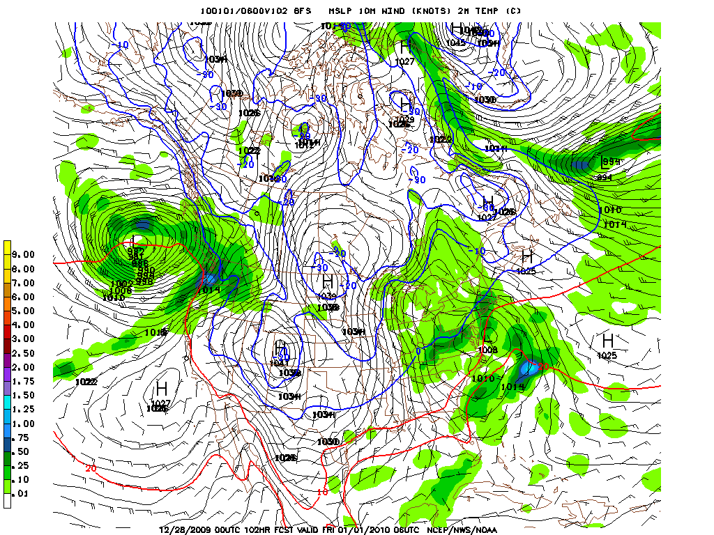
By kickoff of the Rose Bowl the low is deeper and heading into Conn. and bringing heavy snow to southern Vt and NH
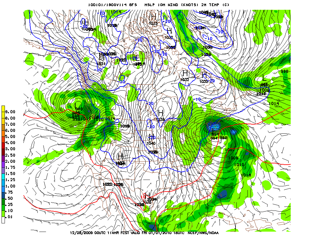
12 hours later, Debbie has barely budged and is now a fully developed Nor’easter. Central pressure of 991 MB, strong winds out of the NW on the back side…fun stuff. Snow at this time would be heaviest in Central VT, Northern VT (Jay and Stowe).
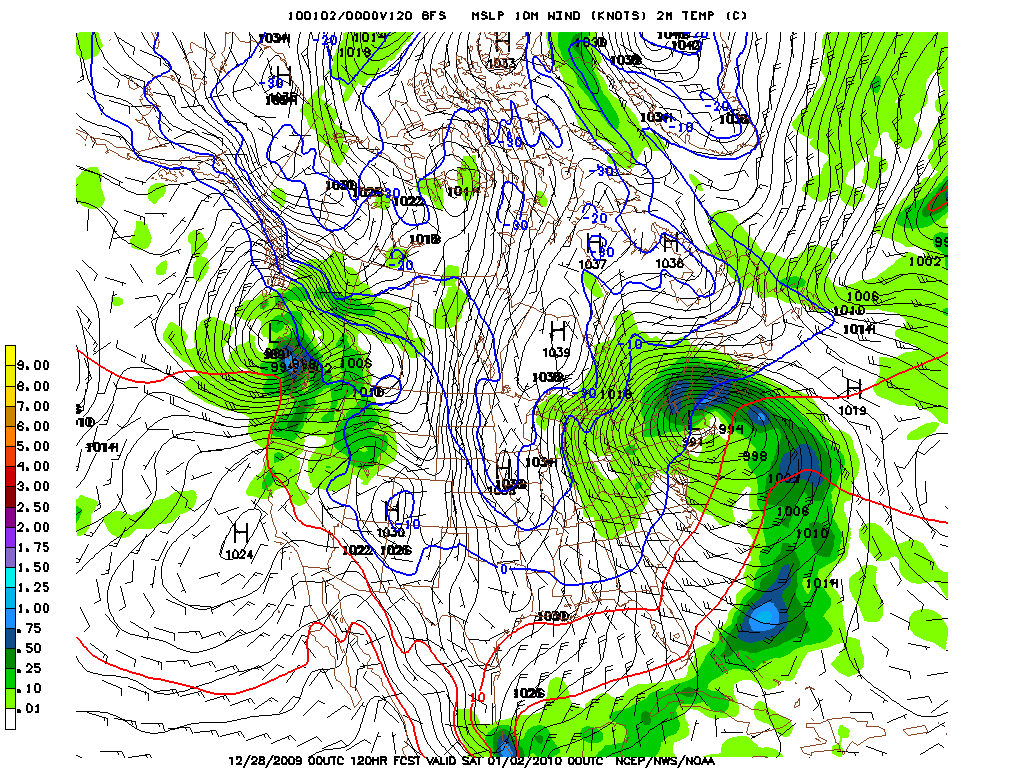
By daybreak Saturday, Deb. is still in roughly the same spot, still throwing moist air back into the North Country. At this point we’re dealing with a fairly long duration event and that’s important.
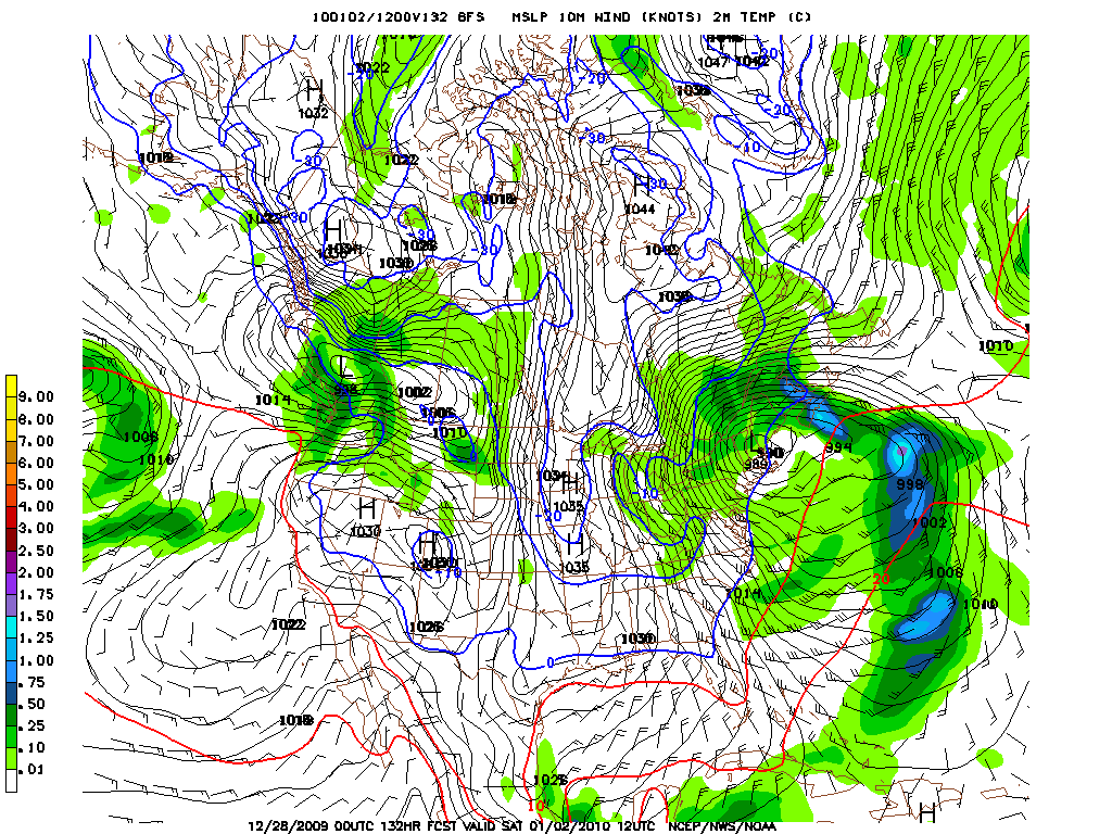
Because of the long duration, QPF amounts are pretty flippin high:
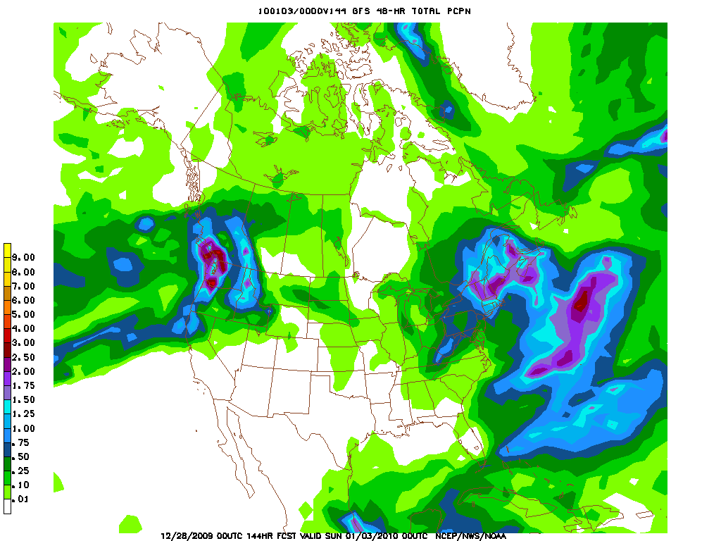
Now, with these systems I think the GFS overdoes the precip both in quantity and coverage. However I think at this time if you live in central VT you are in the primary target at this time for a snowfall above 8 inches.
Here’s how I see the chances of snowfall over 8 inches (my cutoff for bit storms).
Catskills: Elevation dependent, mixing issues, def. enough moisture for 8+ based on current timing.
Wrench in Gears: Deb deepens too late-amts would fall as moisture just wouldn’t be there.
So./ Cent. VT: Def. in most likely place to see significant snowfall. Not saying this area will have the most snow if the track verifies rather this area in my mind has the best chance of seeing a significant snow fall.
Wrench in the Gears: Mixing at lower elevations.
No. VT: IF track verifies Northern VT would see the most snow. Wrench in the Gears: Track stays south/east and never swings into conn.
ADK: 50% chance of significant snowfall. Based on the current track the GFS has the ADK with a very nice storm. I just think the GFS overdoing the extent of the precip from this system. What concerns me is that systems that head into Conn. don’t tend to spread a ton of moisture back into the Adirondacks. Now that’s not to say they don’t, just that it’s more common for the ADK to come up on the short end of the stick. However as the models keep developing the system the ADK keeps getting wetter and wetter. The Euro has a solution that really nails the ADK with wrap around moisture:
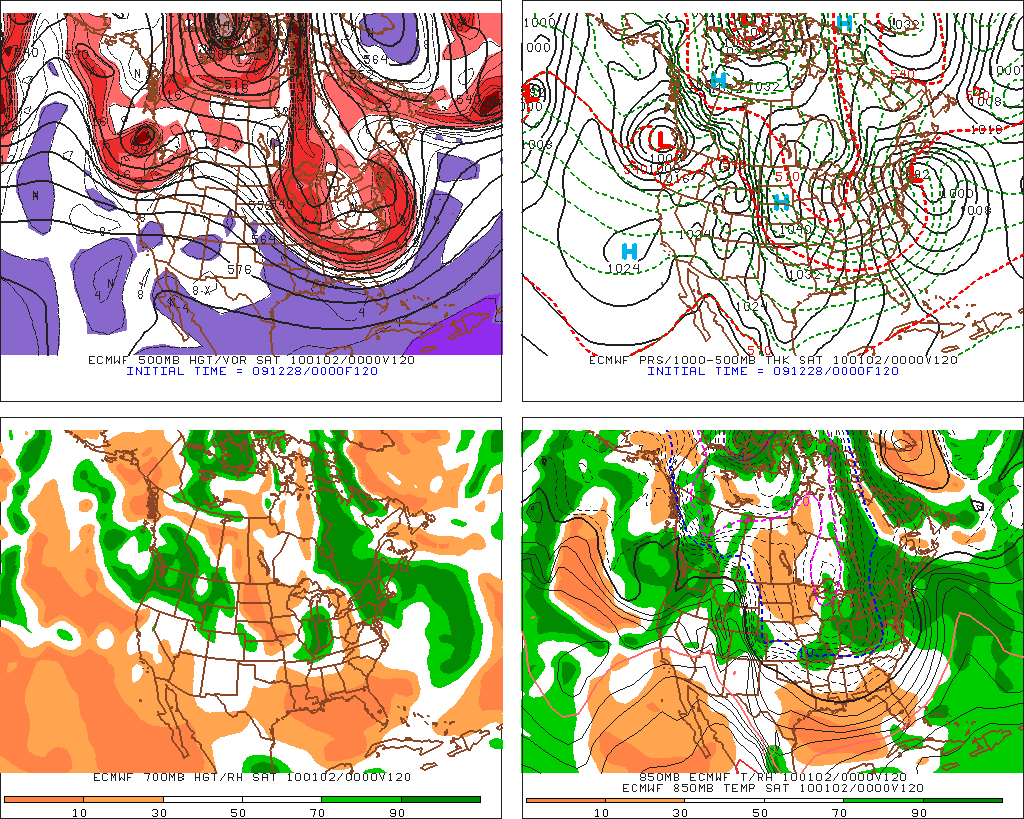
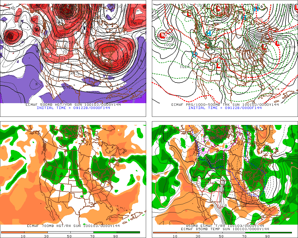
While the Euro hasn’t done great this winter, it has done waypoints well. Meaning that it’s blown the intensity of systems but gotten the a low’s location at a given time right. Thus, you have to consider it’s solution here and the potential for the sustained moist flow over the ‘dacks.
26 Comments
Leave a Reply
|
|||
| Home |




Josh
wrote on December 28th, 2009 at 12:52 pmThanks LH… BRING IT ON!!!
St. Bear
wrote on December 28th, 2009 at 1:18 pmI hate to be “that guy”, but how about the Whites?
Lionel Hutz
wrote on December 28th, 2009 at 1:42 pmTrickier call for the whites. If the Low heads into NH there will be mixing issues at lower elevations. Elevation dependent for sure.
Keith
wrote on December 28th, 2009 at 1:37 pmi’m thinking early night on New Year’s… Off Thurs/Friday and lapping WF. If this ones works out then Sat will be BC day. MayB even the wishbone slide!!!
Lionel Hutz
wrote on December 28th, 2009 at 1:41 pmA) I’m in. Just let me know when!
B) Wishbone = Bennies Brook aka root canal?
monkfish
wrote on December 28th, 2009 at 1:54 pmCold Duck, baby
meanwhile, any update on potential total at MRG by tomorrow a.m.? Still 6+? thanks
Harvey44
wrote on December 28th, 2009 at 3:33 pm“As Debbie Deepens….” I like the storm naming!
Lionel … may the force be with you, and with forcecast option 2.
Greg
wrote on December 28th, 2009 at 5:49 pmLionel is off the charts. Quality!!
T-dub
wrote on December 29th, 2009 at 10:15 amthanks LH for all that, gives me a better understanding of the variables.
i need to look up a lot of the abbreviations, is there a spot on this site with a key chart for that?
Lionel Hutz
wrote on December 29th, 2009 at 10:22 amWhich ones do you need to learn?
ADK/Dacks = adirondacks.
So. VT = southern VT (Kmart and points south…magic area)
No. VT = Stowe, Jay etc.
S/W = short wave energy. A kink which can develop into a storm.
QPF= means the amount of precip (bascially)
GFS/EURO/CMC/UKMENT/GGEM = weather models.
Greg
wrote on December 29th, 2009 at 11:15 amQuality request type comment. I know we have been talking about some tutorial type pages to round out the weather section but that project as a big upgrade will probably have to wat untill summer. On the meantime I think we can swing a quick abbreviation primer. Lionel I you’ve got anymore email them to me and I will whi. This up when I land in slc.
Ps: using free wifi on delta enroute!! Woo hoo
powhounddd
wrote on December 29th, 2009 at 10:34 amWhere do I mail the retainer fee? =)
j/k
but seriously, that cork is gonna pop soon and I will be glad to go fill my glass with some New Year’s powwwwww……
T-dub
wrote on December 29th, 2009 at 11:09 amS/W = short wave energy. A kink which can develop into a storm.
QPF= means the amount of precip (bascially)
GFS/EURO/CMC/UKMENT/GGEM = weather models.
those^ i’ll do a search on the various models, i didnt know qpf either.
thx kindly.
Harvey44
wrote on December 29th, 2009 at 1:03 pmI like Greg’s dedication to the site, and to the east.
Way to post up when you are headed to Wasatchland.
Grant
wrote on December 29th, 2009 at 5:33 pmI really want to say thanks. You have been the most accurate for storm predictions this winter, Lionel. When everyone said 2-4″ here in S.VT you were calling for more and we got it. I hope that you find track 2 getting the higher chance percentage over the next 12-24 hrs!
Aaron
wrote on December 29th, 2009 at 6:41 pmGreat forecast, thanks! I’ll keep an eye on the pow @stowe for ya. :)
Peter
wrote on December 30th, 2009 at 10:13 amso, most forecasting sources are now converging, but there hasn’t been much talk of how the winds will play out over the next ~4days.
At the snow rates I’m seeing predicted, wind could cause more accumulation than snowfall.
Any wind forecasts so we can guess where the pillowy-mounds will be softest as Debbie Does Vermont?
Evan
wrote on December 30th, 2009 at 1:46 pmWill Debbie do Vermont? Please don’t tell me she’s just a tease.
Debbie
wrote on December 30th, 2009 at 3:37 pmVery nice name for a snow storm! People are talking about 16-32 inches of snow…..Do you think we might get this much….I am in Central VT near Stowe:)
Evan
wrote on December 30th, 2009 at 3:49 pmLong and slow is ok too. Don’t feel bad Lionel we get excited too and it’s hard to reign the stoke in sometimes. I like the sound of 16-32 whoever said that.
Could Be Buggy
wrote on December 30th, 2009 at 6:24 pmMs. Hutz checking in – I accused LH of hyping storms – only because I got sad in the pants when I heard that maybe Debbie wasn’t going to do the ‘Dacks! Best weather site ever. K thx bai.
T-dub
wrote on December 31st, 2009 at 3:41 amLH Wrote: “it’s just almost impossible at this time exactly where the convergence of moist air, mountain and winds will happen.”
LH, this is the kind of thing I’d just as soon read, rather than bs predictions of anyting. It explains too, why I heard differing reports from met pros here in CT… that nobody knows quite yet.
anyone asking you “what will we get at x resort”, should just go back and read what you wrote again.
Thanks a ton of pow, or not,… keep it up bud, much appreciated, even when you can’t call anything for sure.
Pablo
wrote on December 31st, 2009 at 12:12 pmVery True T-Dub. Hopefully the next Nor’Easter that happens won’t track east again. Third time is a charm hopefully ! I think the next storm should be named “Shanikua” and she will def not track east.
Evan
wrote on December 31st, 2009 at 12:16 pmDo Noreasters ever really come to VT? Seems like we benefit more from clippers and upslope.
Joann
wrote on January 3rd, 2010 at 10:40 amLong and slow is how it has been falling in the Adks. We received ~10 inches of very light fresh powder in the last 18 hrs here outside of LP, near MVH. Still snowing. The bc was fine yesterday, but this new dump will help.
powhounddd
wrote on January 4th, 2010 at 12:48 pmMontreal got a good clip over the weekend, wind drifts and urban fun to be had. Points east did better, have to get out there and check it soon. Debbie done good.