Pre-Holiday Snows: Eastern flow snows over next 48 hours
Again, moisture retrograding from a coastal low will impact the North Country. Now, last week I mentioned the possibility of the development of NORLUN trough delivering moisture to NH and Maine. Well it looks like this might not develop quite as planned. Instead it appears that an easterly flow from the storm will transport a fair degree of moisture into the North Country and the White Mountains. However here is the funky thing…NWS just really isn’t talking about it. If you look at the models and then compare to their forecast discussion (here is Grey Maine’s covering the Whites) you would scratch your head and say am I seeing things? No you are not…
So…looks like NWS finally woke up. They posted this map tonight at like 7 pm. After it snowed all day. Guess they like being fashionably late. Oh well. Welcome to the party guys. Beers in the fridge.
Original discussion:
Now I don’t really care what NWS is doing. I think they are a great organization but their documented forecasting technique is to FOCUS on areas BELOW 2000FT. Now call me crazy but the best sking tends to occur ABOVE 2000ft. Right? So clearly there is a gap. And that’s where I come in …or at least try to. Most of you don’t really care what id does down in Waitsfield, or Waterbury, or Concord, or Glens Falls or even Saranac Lake. You care what it does UP THERE.
So with that in mind let me jump in and get going…
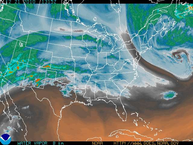
Currently, a fairly large and developed Mid-latitude cyclone is spinning out in the Gulf of Maine.
It can be clearly seen in the color enhanced imagery below. Note the rather robust moist upper layers of the atmosphere (as colored in Green).
This was well modeled more than 4 days ago and was discussed rather fully here. Now while I don’t see the classic NORLUN trough developing, it seems the models were at least correct with the advection of atlantic moisture into the White Mountains and to a lesser extent the Greens.
As has become rather clear over the last 24 hours, this system will deliver moisture on a EASTERN flow into the region. While NW flows are common in parked cyclones (like this one, and this one) sometimes, if the system is situated just so the moisture loses much of the west component and starts to move in from the northeast (yea yea…nor’easter…right…well we are past that…this is a slowly stabilizing and stacking cyclone to some extent that I treat differently than a classic Nor’easter)
Anyway…via the N/NE flow a fair amount of moisture will flow up into the mountains. Orographic forcing will enhance precipitation. Moderate omega values predicted by the models support this and moderate Lapse rates further support the sustained development of orographic snowfall.
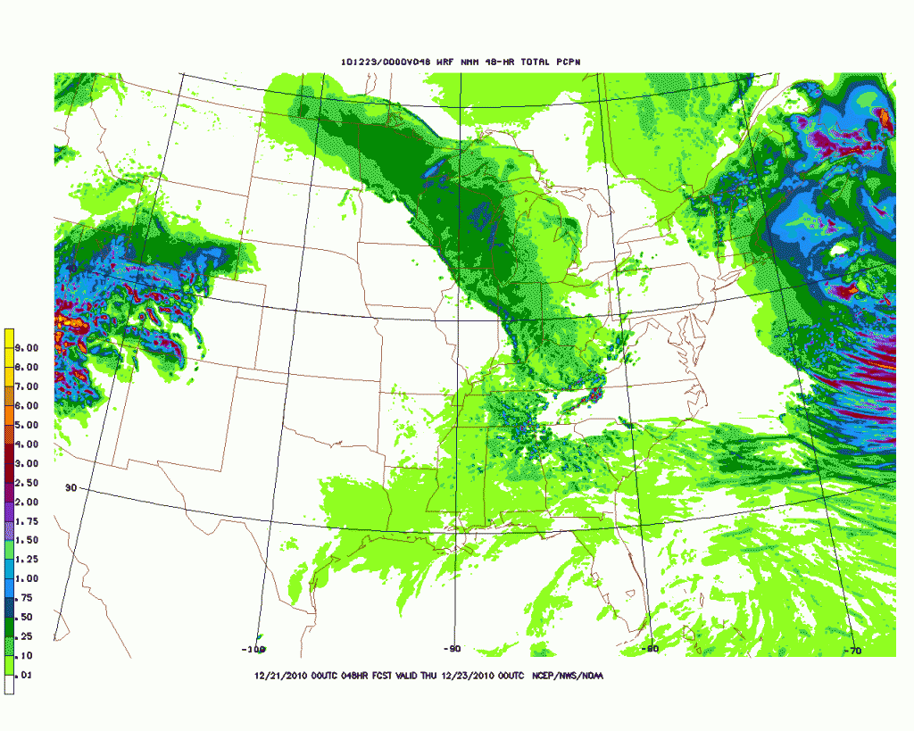
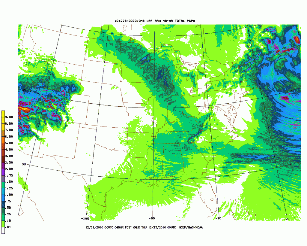
Looking at the High Res. gridded models run by both the NCEP and WRF run by BTV we see significant spikes in precip in the high Whites and east facing slopes of the Greens. (Note – since the NWS/BTV office switched to flash player for their WRF 4km model display I can’t copy and paste images from it. So you will just have to trust me).
The NMM:
The HRW:
Pretty clearly we see upwards of .75 inches of water along the Green Spine with highest amounts approaching 1.25 inches along the EAST facing slopes. In the Whites, amounts of water are approaching almost 2 inches.
Now these High Res models get in the ballpark with total precip pretty well, however I think they might be overdoing the total moisture a touch. Ultimately I have to believe that with snow ratios around 10:1 we should be looking for 6-10 inches along the high east facing slopes of the Greens by early Thursday morning. East in the Whites, amounts should be higher with east facing slopes having the potential to pick up more than a foot.
Confidence for this prediction is tempered somewhat by the limp viagra needing noodle of a discussion by NWS but hey…maybe they broke their necks and can’t look UP THERE where all the fun is to be had.
I’ll keep you updated. Have fun and earn some turns. P.S. Remember to Spay and Neuter your pets!
19 Comments
Leave a Reply
|
|||
| Home |


Affix
wrote on December 21st, 2010 at 11:37 amDamn…no love for the Daks?
Will be up Thursday through New years. Maybe VT day trips…
Lionel Hutz
wrote on December 21st, 2010 at 11:41 amA) Sorry…wasn’t really the focus. Let me see here…I’d go with 4-6 in the High Dacks. They are blocked a little bit as the flow stands right now BUT if we get a little change in direction of moisture I could see them getting into the higher totals as well. Sorry that’s a little vague but it’s kinda the best we can do right now.
B) I will be there as well. Email me and maybe we can schuss a bit. You were up there last year right? Did you ever fix that boot issue you had on the way to Avy lake?
Affix
wrote on December 21st, 2010 at 11:47 amDont be sorry. U summed it up nicely.
YES. Schuss we must. Have my sights set up high. Especially after what Colin posted in the other daks weather discussion from last week.
Im always up there. Parents live in Jay.
Lets keep in tough. How long you up?
Evan
wrote on December 21st, 2010 at 11:38 amThanks for the update.
Doremite
wrote on December 21st, 2010 at 12:57 pmNice LH. Planning to ski Jay Thursday and Friday and 6″+ for the norther greens would be just what the dr. ordered. Happy Holidays all.
Anonymous
wrote on December 21st, 2010 at 4:52 pmHow Much is the Cannon, Burke Bretton Woods Area looking for
Lionel Hutz
wrote on December 21st, 2010 at 4:58 pmA) They can “look for” as much as they want.
B) 12,000,0000,000 feets.
Les
wrote on December 22nd, 2010 at 7:37 amLionel:
C’mon man, start talking about the Sat/Sun event! We’re close enough now that you’ve got to have formulated some sort of opinion as to whether it might bring a big dump or not. What’s the deal???
icelanticskier
wrote on December 22nd, 2010 at 9:11 amthe ocean’s gonna get hammered again les, lets build a big hill on an island out there! hopefully i’m wrong, usually am :)
rog
TSQ
wrote on December 22nd, 2010 at 8:24 amWe need more than 4-6 in the Adks…..things are ski-able, but it is very boney out there. Maybe a big storm blows in with the New Year..?
Josh A
wrote on December 22nd, 2010 at 9:00 am“(Note – since the NWS/BTV office switched to flash player for their WRF 4km model display I can’t copy and paste images from it. So you will just have to trust me).”
Seems like you could just take screen shots, no? should be an easy enough way to get copies of those images
In any case, thanks as always for putting these forecasts together. Your weather beta is really appreciated
Anonymous
wrote on December 23rd, 2010 at 2:28 amWhat’re the chances that monster lurking over the West makes it up our way intact?
icelanticskier
wrote on December 23rd, 2010 at 8:04 amhow bout 1st few days of jan? ;)
looks maybe wet and warm. maybe an 8th holiday/early jan thaw in as many years.
hey, at least it’s consistent! epic consolidation for killer corn later.
rog
Lionel Hutz
wrote on December 23rd, 2010 at 8:12 amWe are SOOOOO far from looking at the first week of Jan. right now. We gotta get through this next major storm threat first.
And I’m 100% sure that a period of warmth will happen in the first half of that month…why? Because it has to. Nature will not allow this massive block to hold steady for 4 straight weeks. Climo, law of averages, and mother nature would just lose their mind.
icelanticskier
wrote on December 23rd, 2010 at 8:46 amcool LH, thanx for keeping us all informed. your generosity and shared professional knowledge goes WAY above and beyond.
now if only i had 7 days off a week to ski! hmmmmmmmmmmm :)
rog
TSQ
wrote on December 23rd, 2010 at 11:24 amIn the neighborhood of MVH in LP – Thursday a.m. – 10 inches of new snow and counting.
Anonymous
wrote on December 23rd, 2010 at 12:32 pmThis is good news. Will be up 2nite through New years!!!
Santler
wrote on December 23rd, 2010 at 11:30 amThanks Lionel. The last 24 hrs. has treated the Greens nicely and as you predicted, the higher elevations aboe 2000 ft. made out well. Followed my gut and your insight and scored 8-10″(?), skied like 12″, of velvet down my favorite wind protected nook on the Man. Still snowing in earnest as of 11:30.
Happy Holidays.