Quick Burst of Snow possible in Southern VT, Catskills and ADK Monday into Tuesday (UPDATED 12/27)
We have a “Weather Thingy” and it’s going to help out snow starved areas of the Catskills and So. Vt.
UPDATE 12/27
Quick update here. Looks like this little thingy wants to be a little more widespread. Latest data looks to take the shortwave over ALB. This would spread more precip into the north country and lower the precip over the catskills.
Last year this was common. Clipper type systems would drift north as they moved east. The models didn’t pick on this very well. Maybe this year they are handling east moving energy better and thus the current northward shift of the primary center of the short wave is accurately captured.
Anyway- As of now I’d give the ADK 2-5, the greens 3-6, southern VT 3-6 and NH about the same.
The thing to really pay attention to is the chance for a long duration snowfall. See this little thingy is just part of the pattern. Over the next 72-96 hrs, a low will be departing thu Canada, this thingy will swing on by, and a significant lake effect event will unfold. Putting all of that together there is the potential for steady light snow from Monday morning through early wed. morning.
As for amounts it’s very hard to make any real statements. Places to look at include K-mart section of the greens, south western ADK and maybe the northern greens depending on how the low closes off and develops a cyclonic flow over N. VT.
Older Stuff
For several days models have consistently show a small shortwave passing across southern NY, MA and So. VT. This feature would be at the base of a digging arctic front. Upper level air will be cool and for the most part areas over 1k will be below freezing.
As this S/W passes the area a small compact strip of moderate show should develop.
At this time I’m pretty confident that for snow starved areas of the Catskills and so. VT this system will do better than expected. Quite often this little clipper type systems out perform the models. Usually I add 1-2 inches onto the model output – esp. for so. vt- where the greens and places like Magic are actually perpendicular to prevailing flow.
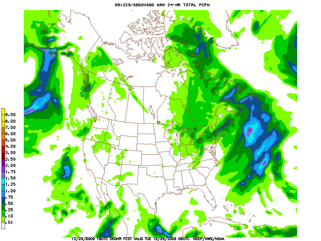
Here’s the latest NAM QPF:

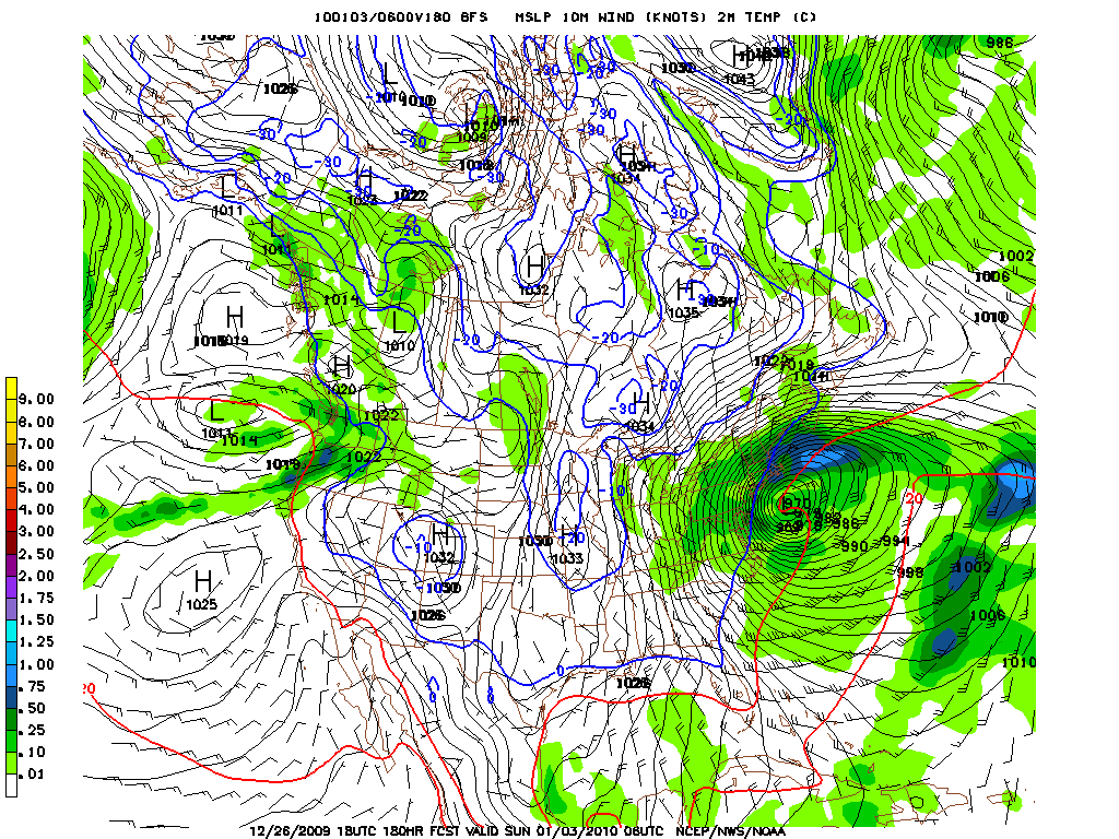
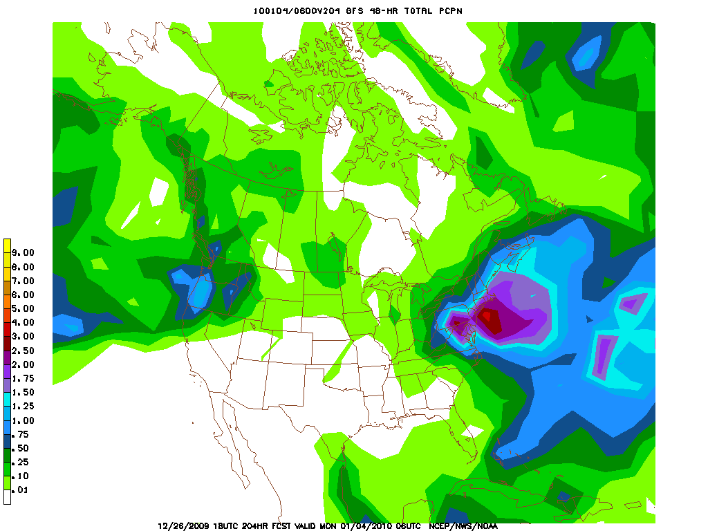
The GFS has the same feature. Interestingly the GFS pumps the system up as it reaches the Cap Cod region. Again, these little systems have a history of doing just this. Based on the numbers, right now I’d say the chances of this happening are roughly 70%. It makes sense but it’s a timing thing so you can never be sure. Once it does pump up a bit it will bring fairly nice snows to eastern/southern NH and Maine.
As for total accums, as I see the system now I feel comfortable going with: (I’d use an MS paint map but my home computer sucks)
Catskills 3-8 (in a localized spots)
So VT 3-5 with up to 8 in a strip of heavy snow
NH: 3-6 with more -up to 8- if the s/w amps up along the coast.
Now…just cause


9 Comments
Leave a Reply
|
|||
| Home |


Powderqueen
wrote on December 26th, 2009 at 10:59 pmlooks hopeful for a snowy New Year…fingers crossed!
Vincenzo
wrote on December 26th, 2009 at 11:31 pmHow’s it affect Stowe? I know its going to be cold, and I bought my wife a better hat, and my daughter a new skull cap, but is it goign to be ice from the rain or will that rain be really snow tomorrow?
jumpin jimmy
wrote on December 27th, 2009 at 8:55 amSunday morning…hunkering down in colchester VT waiting the light rain out. PSA: If anyone finds a bike helmet with a HID helmet mount light bracket on it on the west side of mansfield, it fell off my new sporty (but too small) pack> I don’t care about the helmet, but I need the mount,
thanks,JJ
Anonymous
wrote on December 27th, 2009 at 10:21 amOff topic, but you know what the WORST thing about Stowe is? The webcams.
Greg
wrote on December 27th, 2009 at 12:44 pmThat nyears storm looks like a BEAST. Any NW trends in the gfs this season like seasons past?
Danielle
wrote on December 27th, 2009 at 3:43 pmLionel…say you had to line up a baby sitter to enjoy this potential weather thingy. What day would be better? Monday afternoon or Tuesday? My skiing location would be So. VT/Magic.
Lionel Hutz
wrote on December 27th, 2009 at 6:07 pmTuesday. It will be damn cold however.
Danielle
wrote on December 28th, 2009 at 12:08 pmThanks LH. Good thing I just got a new puffy for Christmas! (-:
Evan
wrote on December 28th, 2009 at 11:57 amI saw your post on TGR about not loving the storm track for the noreaster. Tell me you loving it now…please. I know its too soon but we really need it.