Smarch: In like a slob…(UPDATED WITH TOTALS)
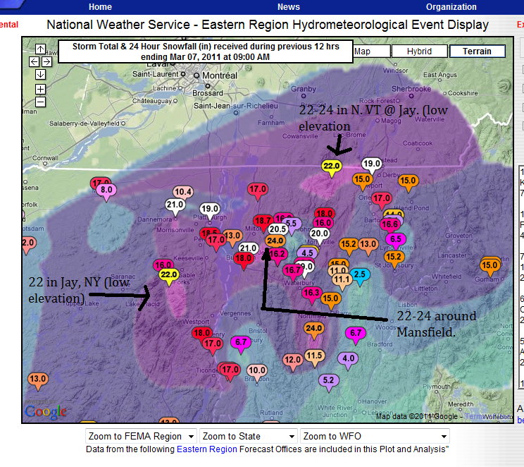
UPDATED TOTALS
BOOM:
MON. AM UPDATE
Well it hammered all night in the ADK and Greens. The area was in a region of prime frontogenesis (the tightening of a temperature gradient along a constant pressure surface) which served to really just spike snowfall rates. As I hinted at to a few of you privately, there was a period of about 6 hours there last night where snowfall rates were easily 1-2 inches an hour across the North Country.
Totals are going to be in the 16-24 inch range across the north country by midday…18 is already reported as of 5:45 in Moriah NY and 17 has been reported in Morrisville, VT…so I’d guess very similar amounts are going to found above 2000ft in the HP and Greens where it changed over much sooner.
WORD!!!
SUN. PM UPDATE:
I love winter storms. Today is the very thing I like best. I feel like a proud parent. I saw the potential for this storm, forecasted it, watched it grow and shrink in the models. Watched the rain move in and out…heard the doubters (cough cough @CouldBeBuggy) and spent all afternoon watching as this system gathered strength setting the stage for explosively snowy night.
I’ll be real simple- the snow line will move east, as a low deepens along it throughout the rest of the day. As it moves N/E through NYC area and out over RI/Cape Code it will bring very heavy weather to the entire NE. Snow totals look very much in line with the upper totals of what I’ve forecasted below with higher amounts possible across the very highest terrain.
SUN. AM UPDATE
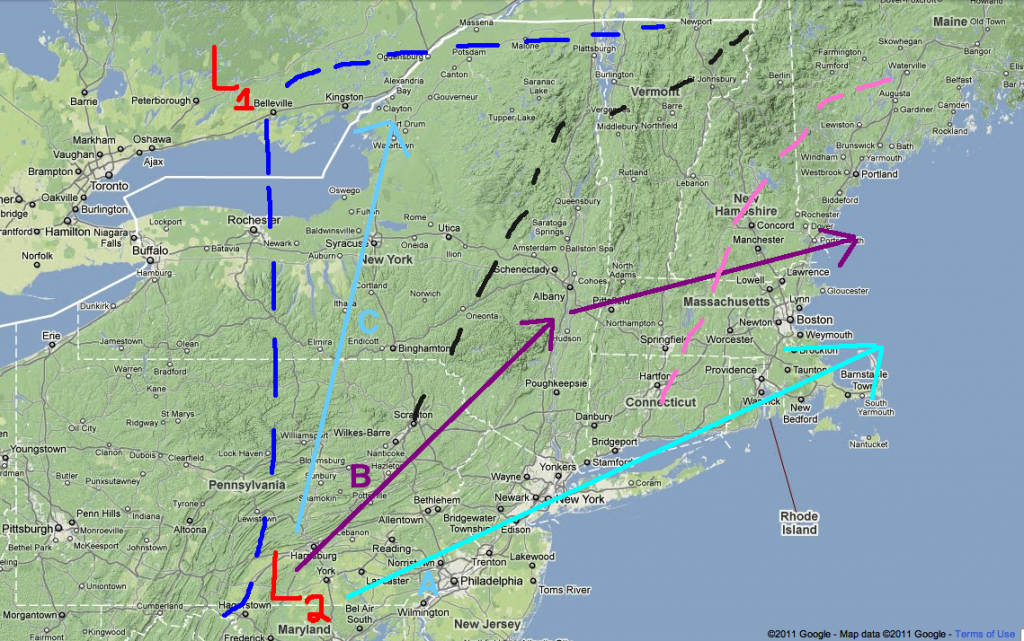
Low pressure us currently forming in VA along the stretched frontal boundary as discussed yesterday. The cold front is also working its way east. These two features will conspire to turn rain over to snow between 9 and 10 am in the ADK and between 10-noon in VT. As the low deepens it looks like it will track close the track B below- maybe even little south of that. This will bring snows thru southern VT and the catskills. The whites will see snow breaking out later today.
Amounts look to be inline with what was discussed yesterday. 8-14 of heavy wet snow in the ADK and Nor. Greens. 8-16 in the Whites. 6-8 So. VT and 4-6 in the Catskills.
SAT AM UPDATE
While there is still large model discrepancy at this point, myself and a majority of seasoned forecasters are honing in on the solution that brings heavy wet snows to the high elevations of the Adirondacks, Greens and Whites. This was an idea I put out there below and felt pretty good about then. I feel even better about it now despite the lack of model consensus.
So let me quickly explain what’s up:
Start with “L1”. That’s the low pressure system currently working into the northern great lakes and pushing a ridge out in the east. The dotted blue lines represent the mean freezing lines tonight. Moving to “L2” This represents the developing wave of low pressure that will be key in the forecast. “A, B and C” represent model predicted paths. I favor B , then A. If B were to verify as the system moved north the freezing line for upper elevations would just about mirror the dotted black line with a few pockets in the central greens. If track A verified the freezing line would be the dotted pink line. Track B brings heavy heavy snows to the ADK and Northern Green Spine then a mix to heavy snow to the Whites. Track A brings lesser snows to the ADK and Greens but pummels the whites early monday morning with up to two feet of very very heavy wet snow. Track C has been the NAM solution and I don’t buy it. Neither does the NWS or several other forecasters I trust.
So what does this add up to?
Areas in blue represent elevations above 2000ft. I believe these areas will see 4-8 inches of snow. Areas in Red approx. areas above 3000ft. I think these areas have a vert good chance of seeing 8-16 inches of heavy snow. Timing this is tricky – but GENERALLY snow should break out between mid-day and late afternoon on Sunday and then continue on into Monday. Over in the Whites, if I’m right on the track it’s generally a 4-8 inch storm with snow mixing in sunday evening and then a change over monday morning to heavy snow. If the coastal track verifies then, as I said, the whites would see the heaviest snows with the above essentially flipping around to favor the Whites.
ORIGINAL POST
Welcome to March. That’s really all I have to say right now. March just is a forecasting nightmare plain and simple. Nothing exemplifies that more than the events due to unfold this weekend. So without dragging you all thru some dead-weight introduction I’ll jump right in…
On Friday night, a surface low will deepen and move into the northern plains. As it does a high pressure system will slide southeast setting up a return flow of air on the back side of the high from the south. With warm air moving north on the eastern side of the low, these two features will pump a dirty ridge of air into the Northeast. Low level to mid level (850 mb) temps will hold below freezing thru the night as the warm air rides over the system. The light to moderate moisture streaming north in the ridge will result in wet snow-sleet- and freezing rain for the ADK and Greens Friday night into Saturday late morning.
By mid-afternoon Saturday much of the ADK’s cold will be scoured out along with that along the higher terrain of the greens. The eastern slopes and valleys might stay below freezing at lower levels (setting up some dangerous icing possibilities). As the low moves eastward it will continue to train moisture into the region. However the total qpf for this period is substantially lower than than previously forecasted. At most .5 to .75 inches of rain will fall in the Greens and the ADk thru Saturday night.
As for the whites…no I didn’t forget you…you actually have a decent day saturday as the moisture hasn’t reached you all yet. Some downsloping from the backside of the ridge might even result in sunny skies.
Ok- so that’s not that hard to forecast…but that’s about to change.
Sometime sunday, a second wave of low pressure will work up along the leading edge of the cold front pushed east by the first storm. From that point the models GREATLY diverge. The NAM has the wave saying open, and really being a non-event. The GFS and the EURO both wrap the low off into a surface cyclone. The GFS hammers the ADK and Greens above 2500-3000 ft. The EURO hammers the whites with two feet of roof collapsing, avy danger skyrocketing snow.
So who to believe? Well the NAM pretty much stalls the system for 48 hours and will likely undergo a phase shift over the next few model runs. That model does well with some things but location of systems that are more than 60 hours away isn’t one of them. The GFS has been consistent with this storm and the EURO seems to agree with much of the solution.
So here’s what I say. Saturday will be kinda rainy but not downpour-ish at all. Afternoon hours will see a few steady to moderate rain showers. Will it wet the snow pack? Yes. Will it blow it out and melt out all the runs? No. So go out with a hard-shell on and find a run that needs some water and warmth to be fun stable and safe.
Then on sunday, I think the second wave deepens tracking a surface low right over S/E NY state into Monday. This favors heavy wet snow in the ADK and Northern Greens and rain to start in NH. NH goes to snow as the system scoots off the coast of Maine and cold high pressure back builds in to the Northeast for the start of next week. Totals you ask? Well, not to cop out but I think we wait on those. This storm isn’t about the totals but the type of precip, so until I feel more comfortable with that question, talking totals is just hot air. Errr…Cold air…
17 Comments
Leave a Reply
|
|||
| Home |


therave
wrote on March 4th, 2011 at 8:08 amThanks for not forgetting us whites. This isn’t as bad as I feared. Go EURO! Hope you can provide an update on Sat.
Peter
wrote on March 4th, 2011 at 10:48 amThanks Lionel.
powhounddd
wrote on March 4th, 2011 at 5:28 pmThanks LH…looks like maybe points North of here may be getting more of the good precip out of the first waveroony here.
Greg
wrote on March 5th, 2011 at 7:54 amoh boi lionel… sounds likethis is gonna be getting interesting on sunday
Anonymous
wrote on March 5th, 2011 at 10:05 amTink the update didn’t get ciopy and pasted quite right. Great otherwise LH!! Thanks.
Anonymous
wrote on March 5th, 2011 at 11:20 amThanks for the fix.
Looks like no matter what someone is gonna win on the EC!!
I hope it’s the ADK!
Peter
wrote on March 5th, 2011 at 1:44 pmguess I’m going to be late to work on Monday.
Anonymous
wrote on March 5th, 2011 at 3:24 pmmmmmmmmmmm…..fresh Smarch monday…..
Could Be Buggy
wrote on March 5th, 2011 at 4:41 pmwoof. dacks gonna get plastered and I’M HERE!
Anonymous
wrote on March 6th, 2011 at 8:05 amThanks for the morning update. I think I’ll check out the ‘face this afternoon.
monkfish
wrote on March 6th, 2011 at 10:03 amCould ratios improve/snow get less cement-y as the storm progresses? Looks like temps will fall steadily from 40s now into the teens tonight. When will precip wind down? TIA …
Evan
wrote on March 6th, 2011 at 10:44 amThe snow has arrived in jeffersonville vt and coming down hard. Bring it!
powhounddd
wrote on March 6th, 2011 at 6:42 pmthere seems to be yet another wave of snow starting tonight?
Simon
wrote on March 6th, 2011 at 10:16 pmSnowing very nicely in Fayston. It is not sierra cement either. It has a nice dense creamy feel thus far with 4-5 on the ground so far. I am hoping the NWS has it right and we get 24 inches!
TSQ
wrote on March 7th, 2011 at 1:32 pm30 inches and the snow is just now slowing down here near Mount Van Hoevenberg in the Adks.
powhounddd
wrote on March 7th, 2011 at 5:43 pmup high must be just SILLY
Butch Chamberlain
wrote on March 8th, 2011 at 11:58 amWell as it turns out, wow! Got sum great white stuff. Pretty solid wind slabs I imagine up in the high country. JP boasting 42″ total. That’s good
JP NEEDS IT!!! Trees were getting really scant, almost diabetic without the white stuff. Ya need white stuff for the fluff. Saw early mornng shot of JP’s webcam. Looking better. NE I believe did quite well. With exception of the Ravines(ol’george). Sounds like not much in the way of epic snow fall.
But got a few inches, and the winds sounded if their direction was favorable.
Should be another one coming soon, to a favorite place. Let’s hope! Pray to Ullr.