Snow Showers Across North Country Bring Back Winter Feel…. (Updated= Success)
Update: Totals![]()
Looks like the event unfolded pretty much as I expected- though HIGHLY variable- with the Bush came out as the winner. Reported totals up and down the spine are as follows:
Jay Peak: 19” (EDIT: As of 1 PM Jay has revised this number to report 12 inches in the past 48 hrs)
Smuggler’s Notch: 6”
Stowe: 9”
Bolton Valley: 5”
Mad River Glen: 4”
Sugarbush: 10”
Killington: 3”
Over in the ADK- Whiteface had 48 hr totals in the 7 inch range with 9 in 72 hours.
Now it’s a little odd that MRG – right next door only picked up 4 in 48 hrs. Might be some under-reporting going on there as I had reliable reports of deeper snow near the top of the mountain yesterday. And then of course there is that Jay Peak number. Now look….maybe the did get 1.5 feet of snow but if that’s the case I’d be really really surprised. I watched this event ALL day yesterday as I was incredibly bored at work and not for 1 second did see atmospheric conditions conducive to 19 inches of snow in Northern VT. So I have to admit I’m skeptical of this report. I’d love to see some snow reporting system like Snowbird’s implemented at Jay Peak as their reported snow totals tend to vary greatly from others up and down the spine. I think this would greatly clarify snow totals and actually significantly advance the study of the Northern VT micro-climate.
Original Post
Been a little busy at real work so sorry to catch you 1/2 of the way through this event. But hey, work happens and unless you all start paying for this blather, then I gotta do something to keep the lights on and the Ms. fed.
Anyway, beginning yesterday a trough with embedded disturbances moved into the northeast. I mentioned this on TGR yesterday. I wrote:
“A weak wave moving from west to east will pick up some moisture as it heads into the central greens and white mountains. Total snowfall by 0z thursday (i.e. wednesday night) will be in the 6 range across the central greens and the 6-8 range in the whites. Catskills, and ADK will pick up a few inches as well but the dynamics best align along the lower green spine and white mountains.”
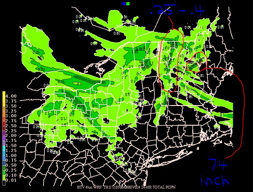
Now, looking at the data, it seems that we should up these totals. The trough hasn’t moved out yet and the flow pattern and embedded disturbances will continue through at least the next 24 hours. Looking at the WRF model run out of btv we see a widespread .25 to .4 inches of liquid along the spine of the green mountains (I’ve highlighted it for you):
Driven by orographic uplift this amount makes sense and is well within reach. Further to the east, it seems the Whites will do a little better. WRF shows .75 inches of precip there. With decent snow ratios and good dendritic growth I’d say the greens should add another 3-5 inches today. A few select regions, where we see some micro climates create surface convergence and enhance the uplift could get into the 6 range. Best places look to be MRG/Bush region on south to Kmart. The whites look to add another 4-6. You might say wow- that’s seems odd- why are the totals so close– well it’s because I think the WRF undercuts the totals in the Greens when snow is driven by orographics, and overstates the totals in the whites as it doesn’t account for the shadowing of the greens. So there…maybe I’m wrong but WTF that’s not the first time!
Notably…down in southern vt, down around Magic, another bloom of moderate precip will be found. 3-5 sounds about right for the upper tops of the hills down there.
So there you go. Two day totals for this event should be in the 10 inch range across the Spine and while not enough to get to full capacity- certainly enough to bring back a winter feel.
Also wanted to throw a note in here…Lake streamers have been doing yeomans work in the catskills all day yesterday and today. Belleayre and the western cats prob. picked up 8 inches already (4:00 pm Wed.) with a few more light inches to go before we get into the weekend.
Now many of you have asked about this “clipper storm” that could develop friday into sunday. Well I guess it’s a reasonable time to address it.
As it looks right now a weak shortwave will move southeast out of the Canadian great lakes bringing widespread light snow to the Northeast on friday. As the wave hits the coast and interacts with a quasi stationary front, it will deepen. A few days ago the Euro model and to a lesser extent the GFS blew this up into a beast that tracked up the coast. I never believed that solution. Now it appears that as the storm deepens it will develop some inverted trough/NORLUN trough to the west. This strip of heavier snows will likely impact southern NY state through So. VT and Mass. Totals in the “strip” would run in the 6-9 range with overall totals in the 2-4 range for the rest of the mountains.
Having been asked to be a bit more specific I would say right now the Catskills are looking at the most snow from this system as it is being modeled.
Now…here’s the interesting part for me. As the storm moves away some models have it curving back through Northern Maine. This made me sit up in my chair because we’ve seen this happen several times already this year so climo supports it. Perhaps it need not be said but were this to happen…this is the result. I don’t really want to go into the dynamics now of how much upward motion, or relative humidity should exist at this time because I think it’s a little soon. Lets just say that right now I’m a lot more excited for the upslope potential from the afternoon of the 8th through the 9th than I am about the synoptic snows delivered by the clipper.
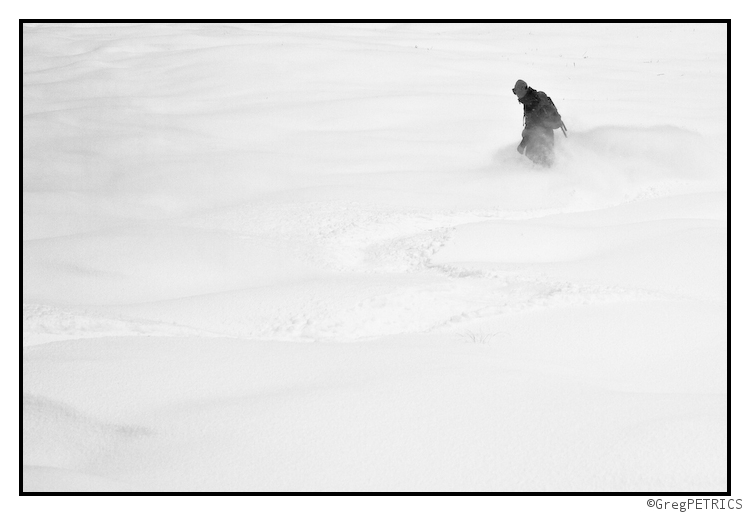
I’ll keep you updated. Until then- check out the great sking our Western Bureau members have been up to.
24 Comments
Leave a Reply
|
|||
| Home |

 Buying lift tickets for a trip you just planned using Lionel’s Forecast? Use Liftopia!


Ben
wrote on January 5th, 2011 at 11:28 amThanks lionel! I’m flying back east today, so it’s great to hear what’s on tap for the weekend!!!
efoxx
wrote on January 5th, 2011 at 12:59 pmThanks Lionel. Maybe you should re-consider your current career and become a meteorologist. Your forecasting is better than any news agencies that I am aware of. Anyone been to Mansfield recently? I was thinking of doing a weekend tour but I know they lost a lot of snow last weekend with the warmth. Is it looking bare at all?
Adrian
wrote on January 5th, 2011 at 3:37 pmI was there on monday and it was rough. Basically back to early dec conditions, with very little open and rather icy trails. I can’t say for sure (as I haven’t even bothered with it yet), but I highly doubt that the bc is in play.
Doremite
wrote on January 5th, 2011 at 1:58 pmAnother big thanks from my sector, LH. I like your optimism for a ‘lil sumth’n sumth’n 8th into 9th. Watching and hoping.
Nick Gottlieb
wrote on January 5th, 2011 at 6:54 pmSkied MRG today…it’s bad news. They got ~4″ of really light fluffy powder today and last night, but it’s 4″ on nothing — the last melt knocked them totally out of commission. Under the snow was rock and grass interspersed with gnarly humps of water ice. It’s going to take a lot to get back in good shape.
Worse than the skiing in October was, because there’s enough powder that you can’t see the rocks, or the rock hard ice.
Greg
wrote on January 5th, 2011 at 8:48 pmoh well….
I think we might have seen you actually today. We ran into a tele skier coming down as we were heading up. crossed paths near the midstation. was that you? indeed rough going… still… skiing 6″ of fluff is better than not! :D

Nick Gottlieb
wrote on January 6th, 2011 at 8:52 amNope…like they always say, fix your heel, fix your problem.
We didn’t get out till 3 or so.
colin_extreme
wrote on January 6th, 2011 at 8:56 amJay tends to have a bit of “magical thinking” when it comes to their snow reports. Sutton and Owl’s Head just over the border reported 15cm (6″) and 11cm (4″) respectively
Big Wave Dave
wrote on January 6th, 2011 at 10:10 amNo Way Jay
man they are full of crap.
why never any burke love?
Lionel Hutz
wrote on January 6th, 2011 at 11:27 am‘Cause I have no idea where Burke is. Gmap it for me.
Roger Kappe
wrote on January 6th, 2011 at 1:18 pmBurke, VT
Great MTB trails in the summer. Never been in the winter, but thinking of trying to get out there this year.
Bill
wrote on January 6th, 2011 at 10:16 amI wonder if sometimes the solks at Jay confuse their meter and yard sticks? 19cm rather than 19″?
Doremite
wrote on January 6th, 2011 at 12:15 pmFor the non-TGR crowd, I emailed Jay this morning and they confirmed their report was in error although as LH pointed out on the forums their expose was swiss. Anywho, they are holding to a legit 10-12″ over last 48 hours. Perhaps fairly realistic if Stowe’s 9″ is legit. I am as big a critic as anyone when it comes to Jay’s reporting. I’ve been a dedicated Jay skier for a decade and have their marketing in my cross hairs. That said, despite this 19″ error, they’ve been much more realistic over the last couple seasons. They dug their own grave a bit by being so liberal the few prior seasons though so understand the skepticism. By changing their marketing slogan from “most snow in the east” to “move up” they now have less pressure to out pace everyone in totals… even though they tend to do that anyway along with Stowe being right there along with them.
Lionel Hutz
wrote on January 6th, 2011 at 12:23 pmWell done Doremite. I’m supportive of a 10-12 inch 48 hour snow total. It’s reasonable and supportable by the overall atmospheric conditions. Prob. what made me so skeptical was exactly the fact you said- they have been MUCH more accurate in the past few seasons.
colin_extreme
wrote on January 6th, 2011 at 12:24 pmso, they should update their website
Doremite
wrote on January 6th, 2011 at 12:41 pmWaiting for that update, which Steve Wright (Jay’s marketing director) indicated would happen. Down side being the 10-12″ allegedly super light so not doing much for needed base. Whatever, can’t complain. Hopefully LH’s thoughts on some kick back snows Saturday night materialize.
Doremite
wrote on January 6th, 2011 at 12:58 pmUpdated. 6″ knocked off their 48 hour report and season total. I feel vindicated.
Sam
wrote on January 6th, 2011 at 5:24 pmseriously awesome work here. Complements all around, this is EXACTLY the type of thing i’d hoped would happen when we first decided to launch a weather section on the site.
Skimohr
wrote on January 6th, 2011 at 6:22 pmThanks for the nice synopsis Lionel. I usually cut most ski area snow reports in half… as most ski areas seem to enjoy measuring snow totals as it snows, at the top of the mountain, rather than giving it a chance to settle out. Regardless of snow totals, this fluffy stuff amounts to approx. 1″ of base-building snow… Every flake helps though, and let’s hope we get really lucky this weekend.
Cliffy
wrote on January 6th, 2011 at 7:35 pmNice work LH – any thoughts on the Cats for Fri-Sun event…what might be in the crosshairs?
Anonymous
wrote on January 6th, 2011 at 7:53 pm12 inches starting yesterday morning through this morning would be spot on, it started with 2 or 3″ on the ground yesterday morning, it snowed very hard at jay all day yesterday with 4-6 during the day with another 6 overnight into this morning. They double measure, it happens all the time. a funny side note is that the season total from the record season of 2000-01 was always reported as 571″ i still have the tee shirt. The funny thing is that at some point this year, they decided it snowed another ten inches back in 00-01, so that they now report 581″ for the record year, jay peak still up to their sneaky snow reporting, i don’t think they are really fooling people much anymore.
Bill
wrote on January 7th, 2011 at 5:52 amthe one and only time i went to Jay was during 00-01, later in the season, think they were reporting 400″+ at the time, I rode a half day of disappointing snow and went back to stowe where there seemed to more snow, of better quality. Have not considered Jay since.
Lionel Hutz
wrote on January 7th, 2011 at 7:57 amThanks for the comments guys, but lets not let this devolve into a “bash” jay thread. Clearly they had some glitch and reported the wrong total. It happens. That’s one of the primary reasons I’d like to see ski areas implement the camera system like Snowbird uses.