Upper Level Low putting the ULL in Ullr? (Update as of 1pm Tuesday)
My affection for Upper Level Lows is pretty clear. As is my love of all things pagan and norse. Lucky for me, it seems this week will combine these two loves and bring the Northeast some interesting weather.
Beginning on Wednesday, a long duration, complex, and at times, messy weather event is going to unfold over the northeast. It could be very snowy; or it could be just kinda snowy. That’s unresolved as of now. At the very least I think there is a btter than 60% chance that elevations above 2500 in the ADK, Greens and Whites come out with a net gain in the 8-12 range when all is said and done.
Let me explain.
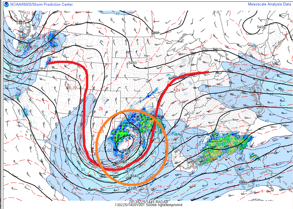
Currently a trough with a closed 500mb low is pushing out of the intermountain west.
This is the same weather system that brought 20 or so inches to Utah Friday into Saturday.
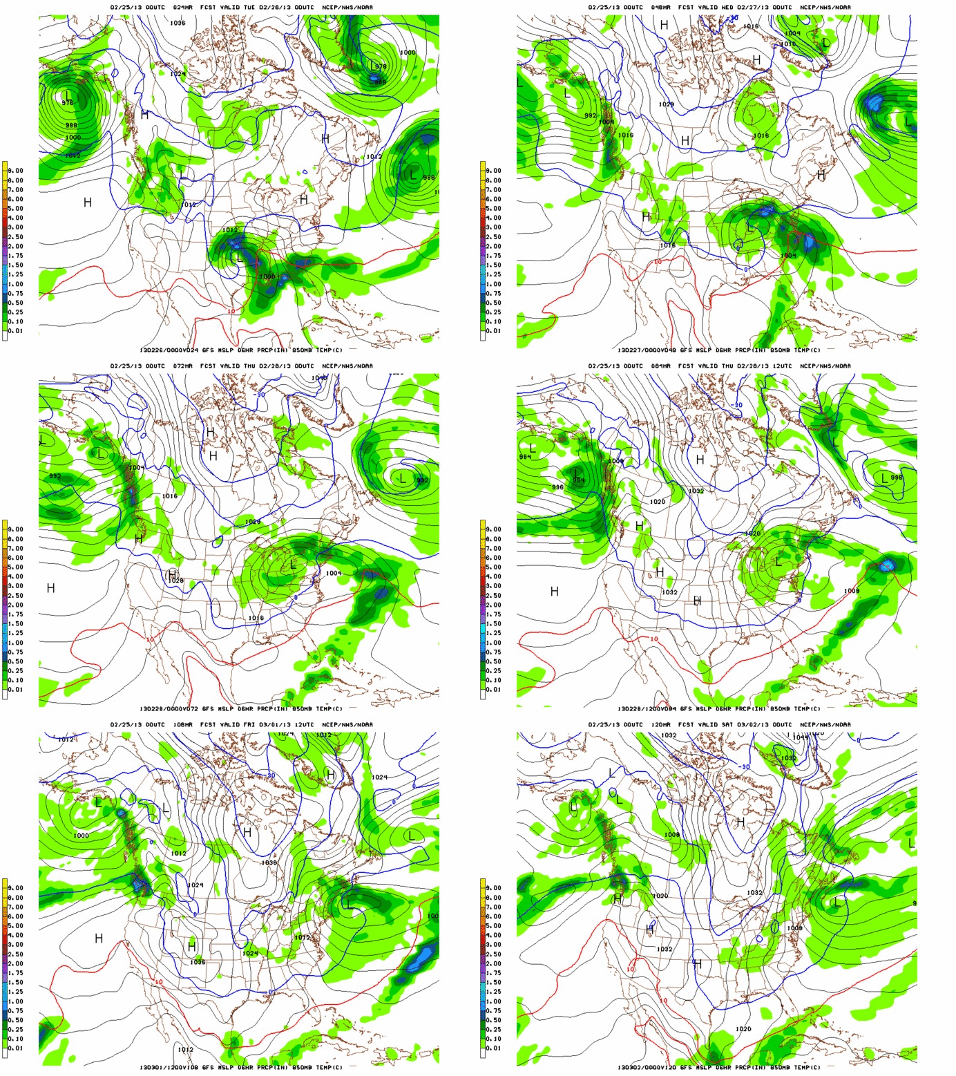
As we go through the week, this is the weather system that will impact the Northeast as it moves into the center of the country, and drifts slowly east.
As we can see in the gif above, the primary center of circulation will first move northeast. The low will fully occlude (the cold front associated with the low catches the warm front) somewhere in the Ohio Valley. This occlusion will come juuuuuuuuuuuuust as the warm front associated with the low is pushing into the northeast. The low will vertically stack up (centers of low pressure at all levels of atmosphere occur on top of each other) and cut itself off from the trough moving east.
At about the same time (wednesday during the day) a weak area of low pressure will develop along the coast. In reality this will just create one large spread out low pressure “region.” The combined effect will be to draw some cooler air into the northeast, pushing most all elevations below the freezing level by late Wednesday.
From Wednesday onwards through early Saturday, the large, vertically stacked, and cut off low will slowly drift eastwards. The EURO is the most progressive model and scoots the low out of the region late friday. It’s also the strongest so the faster pace makes sense. The GFS and NAM both linger the low into saturday morning.
Breaking this whole thing down here is what I can say.
– Snow breaks out wednesday across the N/E. Heaviest stuff is likely in the ADK. Some mixing will occur in VT and the ADK as warm air moves in at the mid levels of the atmosphere.
– Strong, moist southeast winds could spark some heavy upslope snow in/around Mt. Wash (yes, upslope on an east wind happens over there).
– By wednesday afternoon/evening everything should be back to all snow.
– The stable low will move through the region slowly from wednesday night to friday.
– Upslope dynamics don’t look insane right now but these events make pows. Simple as that.
– The ADK will see the best “synoptic snow” Wed into Thursday. As the low moves through NYS and So. VT and shifts the winds to the north, the upslope dynamics will favor VT.
– Overall, widespread 6-12 seems reasonable right now. I’m going to leave open the possibility to bump this up into the 12-20 range for parts of the Greens depending on how the upslope signal develops.
1 pm Tuesday Update
So, the storm is going to linger in such a location that instead of a prolonged NW wind upslope induced event, it should have a prolonged E/Southeast wind factor. That favors the White mountains, Southern VT and the Eastern Slopes of the Eastern ADK.
So I think my updated totals are as follows.
VT: Border to 89, 6-8ish, 89 south 6-12.
ADK: Eastern most slopes 8-14, more n/nw zones 6-10.
Whites: Feet are possible.
End Update
12 Comments
Leave a Reply
|
|||
| Home |


Rif
wrote on February 25th, 2013 at 6:51 pmthanks for the write up. cheered me up from my case of the mondays.
mtl_ripper
wrote on February 25th, 2013 at 7:33 pmdang I like the sound of all this. Really great closing remarks for February: well done, month!
peruvian
wrote on February 26th, 2013 at 11:21 amAny idea of the timing of this event? NOAA’s got a winter storm watch for So VT and is calling for 6-12″.
Greg
wrote on February 26th, 2013 at 1:35 pm“feet are possible”
xD
Greg
wrote on February 26th, 2013 at 4:30 pmalso: what do you think the are chances that the storm will be putting the “ULL” in “pULLed pork tacos” instead?
Lionel Hutz
wrote on February 26th, 2013 at 5:49 pmUber Chia.
birdman
wrote on February 26th, 2013 at 10:50 pmhow bout a mention for da laurentians?
GFS seems to think they’ll outperform the bunch.. maybe it’ll pile up a bit more since it’ll be a little colder up there..?
MadPatSki
wrote on February 27th, 2013 at 1:23 pmSnowing real hard in Ottawa. Precipitation started as Ice pellets for 5 minutes at 9:15, full snow 15 minutes later. EC calls for 6-8 for the city.
bushman
wrote on February 27th, 2013 at 2:06 pmsnowing hard @ JP; figure FIS on recon local hills this afternoon; hoping pics & full report for breakfast
Paul
wrote on March 4th, 2013 at 1:42 pmFeet don’t fail me now!
Merritt
wrote on March 6th, 2013 at 1:06 pmLionel, your mother put me on to this website. I will thank her/ It is a great site!Your weather analysis is better than what we usually get. Factual, clear and a wonderful touch of humor! We were in Sugarbush and Stowe 2/23-3/2.
No sun, but lots of fun
jack
wrote on August 19th, 2013 at 7:39 amAppreciate sharing superb informations. Your site is very cool. I’m impressed by the facts that you’ve on this internet site. It reveals how perfectly you perceive this specific subject. Bookmarked this web site, will come back for more articles. Anyone, my pal, Stone! I found the info My partner and i already researched all over the place and merely couldn’t come across. Such a perfect web-site.