Upslope event of debatable strength set to affect North Country (Updated 2/20/10)
Over the next Starting later tonight and continuing over the next four days (wait let me check..thurs, friday, sat, sun…good ok 4) a prolonged orographic lifting based snowfall is set to affect the North Country with the most focused precip falling along the northern Adk and Central to Northern Green Mountains
2/20/10 Update
Looks like we have another round of light upslope possible today into tomorrow morning. Best dynamics should remain over the green spine and high peaks. 2-4 inches possible.
2/19/10 Update
A quick peak of the morning radar and data reveals what looks like some nice upslope snow. I’d go with 2-4 today along the western slopes of the greens with 2-3 along the western slopes of the ‘dacks.
2/18/10 Update
– afternoon thoughts: Not in love with how this is coming together. A review of the webcams up and down the spine doesn’t really show what I’d like to see. Might have to bump totals down to the 3-4 inch range if I don’t see some changes by the evening. Just don’t “feel” this either. But that can change.
The first round of upslope – say the next 24 hours- looks target to mainly Central and So. VT.

Now whether that hole over the norhern ADK and greens is really just some crappy model feedback problems or a real issue doesn’t change the fact that central vt south looks best over the next 24 hrs.
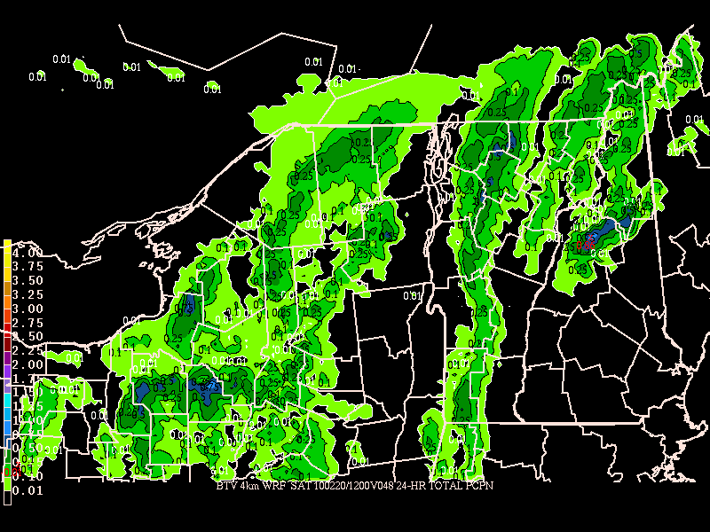
From Friday afternoon on, I’d suspect the ADK and No. VT to get more into the aciton. The local WRF picks up this shift well and shows some deeper pockets over the northern greens.

So to recap- starts south, moves north. Totals will vary greatly but 4-8 seems reasonable.
Older stuff
Currently, a surface low is sitting right over Halifax (not at anybody in Canada has noticed, what with the Canadian Men’s Hockey team squeaking out that 8-0 nail-biter). This surface low is, for all intents and purposes, not going to go anywhere for the next 96 hours. This will allow the low to flatten out and become stable and vertically stacked. This is a key ingredient for upslope events. Stationary lows/broad troughs create favorable conditions as they keep winds steady from the W/NW at all levels of the atmosphere. When placed right they also draw in moist air (the other key ingredient).
Here we have a very good set up though I’d like to see the center of the low a little further west. Regardless beginning sometime wed night light snow showers should begin along the western and northern slopes of both the ‘dacks and the greens.
The intensity of these snow showers is the real question. Based on model soundings and data there is good support for at least periods of heavier showers as deep moisture in the air combines with lifting and a few weak upper air disturbances over the area.
However the models are having a hard time honing on the amts of precip.
Over the next 48 hours there seems to be a general consensus that 4-7 inches are possible along the green spine and localized sections of the ADK with the heaviest precip falling towards the end of the period. There are some notable differences
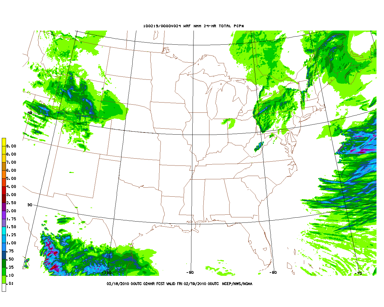
The High RES NMM model shows the heaviest precip occurring from Kmart south in VT with heavy pockets in southern VT and along the western ADK slopes with a lollipop over the high peaks. This meshes with the current wind vectors pretty well.
The High RES NOAA run WRF model keeps the heavier precip along the northern spine of the greens and is a little drier.
The local WRF run by BTV agrees with the NOAA WRF but is a little wetter.
To be safe I’d say look for a general 4-7 inches by friday across the green spine with a little less in the ADK ski areas but with a good dose along the western BC slopes.
As we move into the weekend the overall pattern remains the same so expect continued snow showers. The target zone at that time will depend on the placement of the stacked low in canada.
Also be aware that this pattern will have breaks. Some sun will poke through at times. Don’t take this to mean all is lost. This is just an unstable pattern and that happens in unstable patterns.
17 Comments
Leave a Reply
|
|||
| Home |


Big Wave Dave
wrote on February 17th, 2010 at 9:38 amwhat ’bout the NEK???
Lionel Hutz
wrote on February 17th, 2010 at 9:48 amGreen Spine v. NEK? What’s the difference?
Ben
wrote on February 17th, 2010 at 11:28 amI like!!!
Evan
wrote on February 17th, 2010 at 11:58 amReady here. Bring it.
Big Wave Dave
wrote on February 17th, 2010 at 3:47 pmwell many differences. the greens are a seperate mtn range for one, the NEK is considered the “piedmont” of the whites. c’mon now.
I will consider your response as a positive however and get ready to shred my fav bc spots. appreciate the info and occasional (warranted) jay-bashing on this site.
Lionel Hutz
wrote on February 17th, 2010 at 3:54 pmWhat ski areas are in the NEK?
Greg
wrote on February 18th, 2010 at 9:21 amThanks for the comment Dave… Jay bashing? I think it’s all in your head :D
Big Wave Dave
wrote on February 17th, 2010 at 5:06 pmserously? burke, jay for the lift inclined crowd. for those who seek more, ahh, manual means of accessing lines, limitless.
Lionel Hutz
wrote on February 17th, 2010 at 5:12 pmI consider Jay part of the Greens. When I talk about the northern greens/northern green spine that generally includes jay. Whether this is correct isn’t going to change that…so hopefully that clears up some confusion.
Greg
wrote on February 18th, 2010 at 10:11 amThanks for the update Lionel. I’ve seen some real issues with the BTV hi res WRF RH forecasts recently. There were times last week when it forecast 90%+ RH, and we were bone dry with clear sky and low humidity. This was during the event where the semi-stationary low in the maritimes was supposed to usher moisture in from the NW. Did the low just not have the gumption to scoop up the moisture as the WRF forecast?
Lionel Hutz
wrote on February 18th, 2010 at 10:32 amSound a little sandy to me….I dunno. Sometimes stuff just doesn’t play out like expected. Hence the “we’ve seen set ups like this flame out previously this year.”
Greg
wrote on February 18th, 2010 at 11:10 amNah… I mean i’ll live whether it nukes or not. BTV forecast 2-4″ from moisture being drawn in from the NW one day last week, and we had dry bluebird… I’ve never seen them that far off before, and wondered if you had any idea what was confusing the WRF. Are these maritime circulations just notoriously hard to forecast?
Lionel Hutz
wrote on February 18th, 2010 at 11:43 amWell they are. Remember models 24hr qpf or 12hr qpf are cumulative totals. So say we’re talking about an upslope event where you’re expecting like 6 inches in 12 or 24 hours. Not a bad event for sure. Say we have normal winter temps and are going with a conservative 12-1 or snow ratio. That means we’re looking at .5 inches of liquid. Over 12 hours that’s .04 inches of water an hour. Not very much. Even a more robust event merely doubles that number. So if the model over does the precip per hour by 50% you can see how easily this whole thing flames out.
Now as for sn v. bluebird. Sometimes winds and lift just don’t work out right. Sun pops out and dries the atmosphere, layers get stuck, cool air hangs around…anything is possible. Upslope events are are very tricky because they really depend on a whole slew of factors coming together. personally I think they are way more fickle than LES snow.
Chesser
wrote on February 18th, 2010 at 3:20 pmOn the ground report from Bolton Valley: the upslope delivered modestly here, at least. Steady snow all morning, leaving a legit 3-4″ on the hill. Winds picked up a bit late-morning, so more than that may have fallen. Don’t know how neighboring mountains did, but this northwest-facing slope did pretty alright so far.
powhounddd
wrote on February 18th, 2010 at 3:38 pmI still don’t understand how an event favouring upslope snow has it snowing in Montreal also sometimes. I don’t get where that snow came from.
Evan
wrote on February 19th, 2010 at 6:48 pmJust looked at the noaa forecast for tonight and sat. please say it isn’t so. wintery mix just isn’t what we need
Evan
wrote on February 21st, 2010 at 6:26 pmWow that wintery mix turned out good