As we enter what we all know is the heart of winter, the Catskills, Adirondacks and Southern VT are looking at their first synoptic snowfall in a long time.
2/16/10 Update
Well this system sorta broke apart. One piece of energy is bringing snow showers to western NY while another is developing off the conn. coast. This second part should spread some light snow into southern vt and the berkshires. It also should deepen a bit and spread decent snow into NH.
Interestingly it will then set off a prolonged upslope event in the greens and adk. Any guesses with regards to total snow with this event however has a low forecast confidence. Models are really all over the board with the depth of moisture, temps in the snow growth layer and wind consistency. We’ve seen these set ups flame out this year when they look good and blow up when they look like nothing.
Right now I’d say a conservative middle ground approach is best applied.
I’d say 4-8 in the ADK, 5-10 across the green spine, with pockets approaching a foot on Manny and Jay by the time this all wraps up friday/friday night.
Sorry I can’t do better than those ranges. I really have to blend all the guidance here and I’m not even happy with that solution. On a scale of 1 to 10, I’d say my forecast confidence is like a 3.
Update 2/15/10
Well the models continue to have problems with this system. Latest trends keeps the low open along the coast. This results in much lower precip in the catskills and slightly higher precip in southern vt. However if the 0z NAM is to believed the newest target zone would be NH until at least the low backs into Maine and upslope enhanced flow begins in VT.
Since there are modeling issues with this guy I’d say the best bet is to wait until tonight/tomorrow am early before making the call as to where to go.
As we speak, a weather disturbance is sliding through the central Mississippi valley. The wave can be seen clearly on the sat. image below.
As you can see my MS Paint program works and you are prob. wondering what my doodles mean. Well the Red “L” is the low. Confused by that and I don’t think I can help you anymore. The blue dotted is where I think temps will favor snow. The green line is the expected path of the system.
As you can see the disturbance will proceed east into the Mid-Atlantic. However, unlike the past several storms this storm will remain further inland and move more north. This means areas that have gotten skunked (Catskills, So. VT, Northern VT, NH) have a much larger chance at snow.
The GFS shows the surface low pressure system beginning to deepen just inland of the NJ coast.
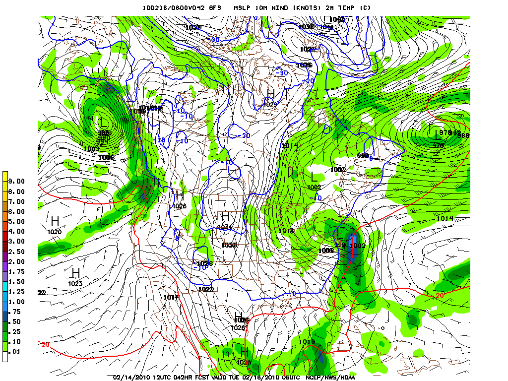
By Tuesday afternoon the storm has deepened to a central pressure around 990mb and is centered off NY.
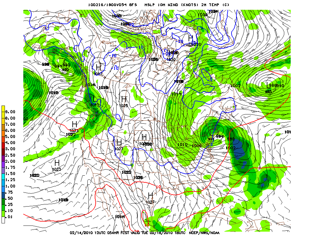
Two things are notable about this image. First, you can see the deformation zone/heavy pocket of snow back to the west of the primary low. Based on the mean position of the low among all the models, this pocket should generally reside over the Catskills. Second, you can see the storm just beginning to tap Atlantic moisture. However it still remains dry relative to the systems which have affected the East Coast this winter. Either this signals a change and we’ll start to see drier more northerly moving systems or something is wrong. My two cents is we get a little wetter.
If we get a little wetter, by Tuesday night some good things could happen.
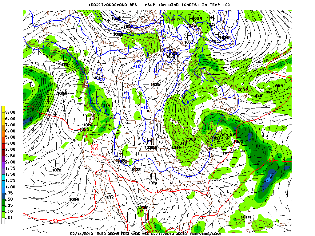
As you can see by Tuesday night, the center of the low will be in southern New England and moisture will be spread inland. With the position, the winds over the ADK and Greens will be out of the west/northwest/north. This should allow for some upslope enhancement. Thus you have to take the predicted QPF with a grain of salt.
Speaking of the QPF:
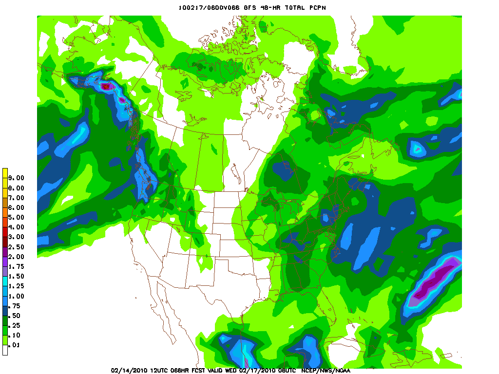
Now the NAM, which was in the closed deep low camp as late as Friday, has now moved to keep this low as an open wave that doesn’t interact with much Atlantic moisture until the Low is closer to Cape Cod/NH. If this happens the target zone moves east into the Berkshires/So. Vt and NH.
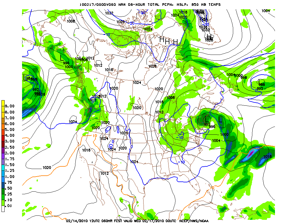
Not sure I really like this solution. The NAM has had some odd solutions 42-66 hours out from storms this year and this feels like one of those solutions. Some have actually turned out right but it is tough to really believe this solution right now.
The EURO seems to agree with the GFS.
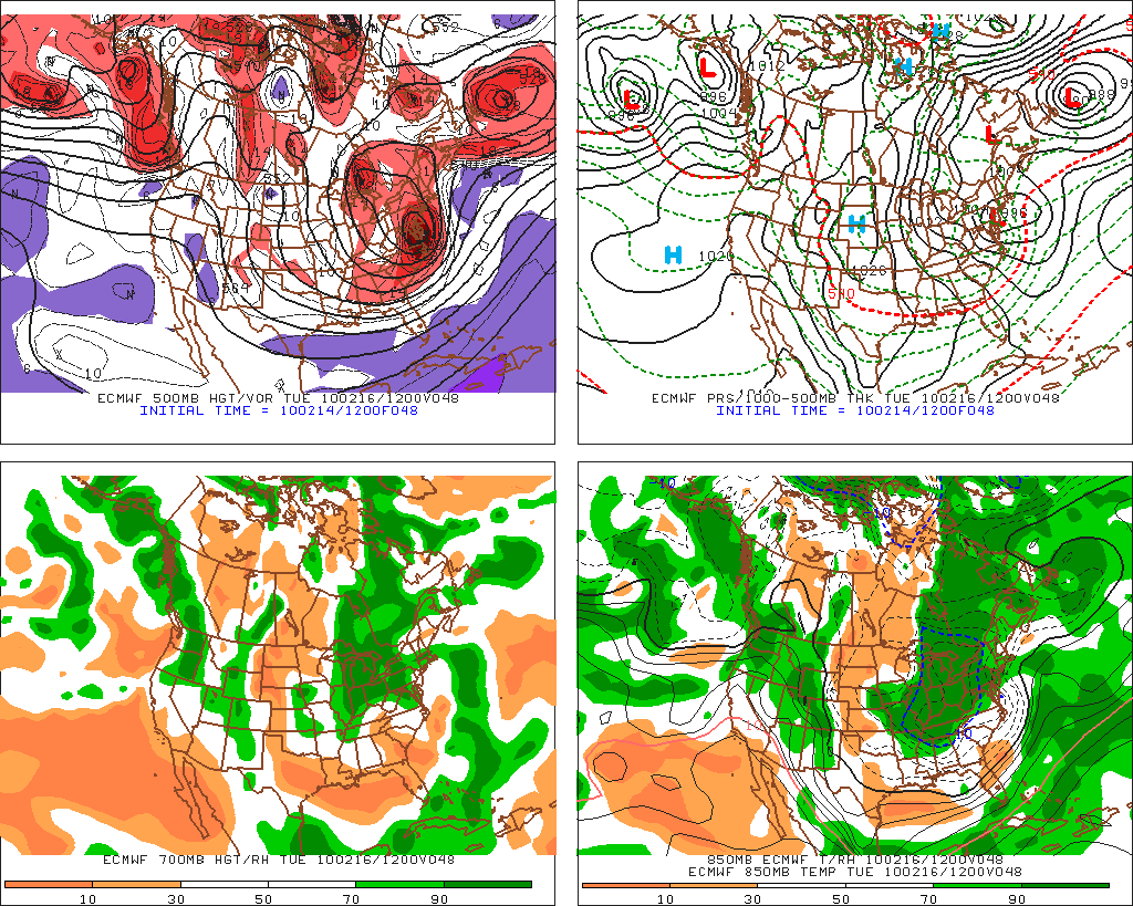
The Euro believes that the L will deepen around NY harbor. If this happens I suspect, regardless of the rest of the track the Catskills and So. VT will be in the honey pot.
Overall, right now I’d say that the Catskills have the best chance for a 10+ inch snowfall. For areas to the north and east we really have to watch the track and the timing of the tap of moisture. Also, we have to carefully watch the set up for upslope enhancement.
Stay tuned.
5 Comments
Leave a Reply
|
|||
| Home |





powhounddd
wrote on February 14th, 2010 at 3:59 pmThank you for the on-point analysis.
I did ask for snow for my birthday and I guess Ullr might be listening…
Greg
wrote on February 14th, 2010 at 4:15 pmwoofity woof woof. NWS is also getting on the bandwagon with the vocabulary today being: “a prolonged and significant upslope event is possible.” Synoptic, microscale, or “magic,” I think we’ll all take it!
powhounddd
wrote on February 15th, 2010 at 9:24 amc’mon snow! 3 for 1 special!
Greg
wrote on February 16th, 2010 at 8:19 amThanks for the thoughts dude.
powhounddd
wrote on February 16th, 2010 at 8:26 amSo basically, those of us who will be in the right place at the right time will score big time, those who stay home won’t get any, and those who are in a decent spot will get some. That sounds like a decent adventurous ‘cast to me: let’s roll the dice and see…