What comes in the wake of Midweek Mess? UPDATED: 12/8
As Scott has pretty much covered the Midweek system as I would I’m not going to add very much. I just want to comment on the latest trends with the system and then talk about what’s on tap for the weekend.
First the latest trends in the Midweek Storm:
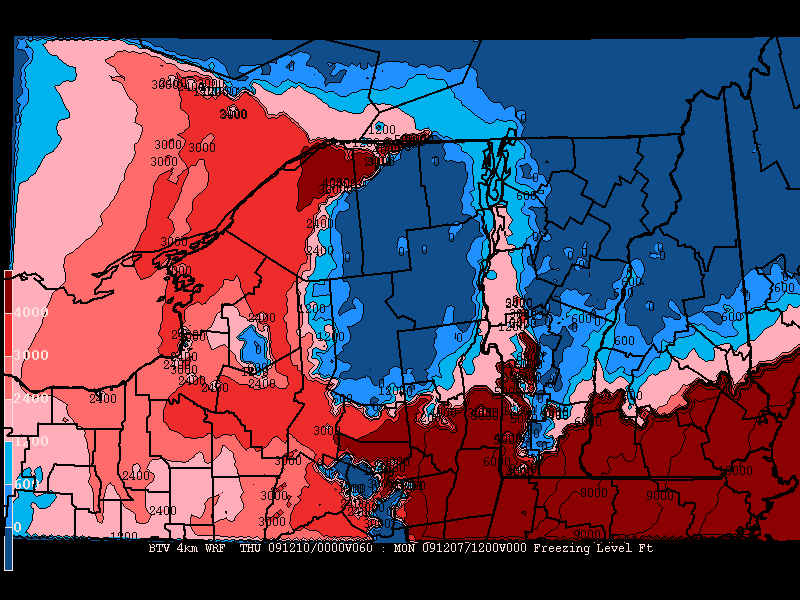
The latest model run shows lower level temps (2m and h85) staying below freezing for much of the event. However, upper atmosphere temps will push JUST over the freezing mark and that’s not great. Personally I could see places like the high peaks and northern greens staying away from the rain but getting a solid dose of Not Snow. Originally my concerns with this system was heavy icing. I don’t see that being a huge problem right now. But be sure some areas could get nicked with a nasty little bout of freezing rain.
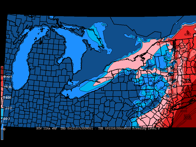
Here is the freezing level by 7pm wed. night:
Here is the total precip by wed night:
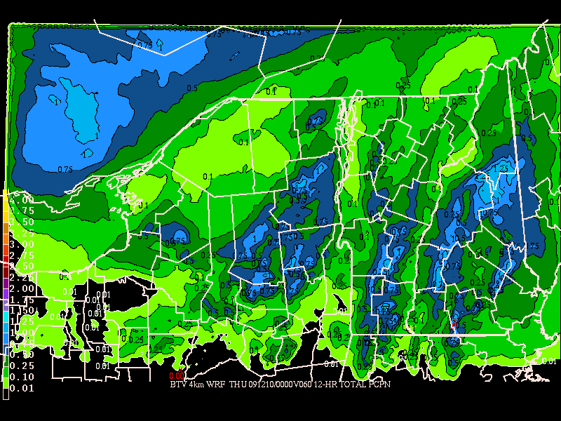
Based on what’s scott’s laid out (which I agree with) I’d say we’re looking at 4-7 inches of snow on the front end of this system for the higher terrain before either a dry slot works in between the dying midwest L and the developing coastal low, or enough warm air works in to shut off accumulations (by bringing ZR or rain).
In the wake of this system the lakes look to go off. Plain and simple. Somebody is going to get a big dump. As the system departs it will pull a strong arctic cold front across the great lakes. Winds will remain generally steady for almost 48 hours. With lake temps running well above normal and ample cape values predicted I can see the precip down wind of the lakes being legit. Additionally, with solid RH values all acorss the north country I could see even the ‘dacks and greens tapping into some of this mositure. Also as the flow turns a little more NW by saturday, the north western catskills- plattekill for example- could begin to see snow off the lakes. For those that know, plattekill’s orientation does a great job sucking any moisture out of the atmosphere and when there is a downwind flow off the lakes, a predicted snow flurry can easily turn into 2-4 inches of softness.
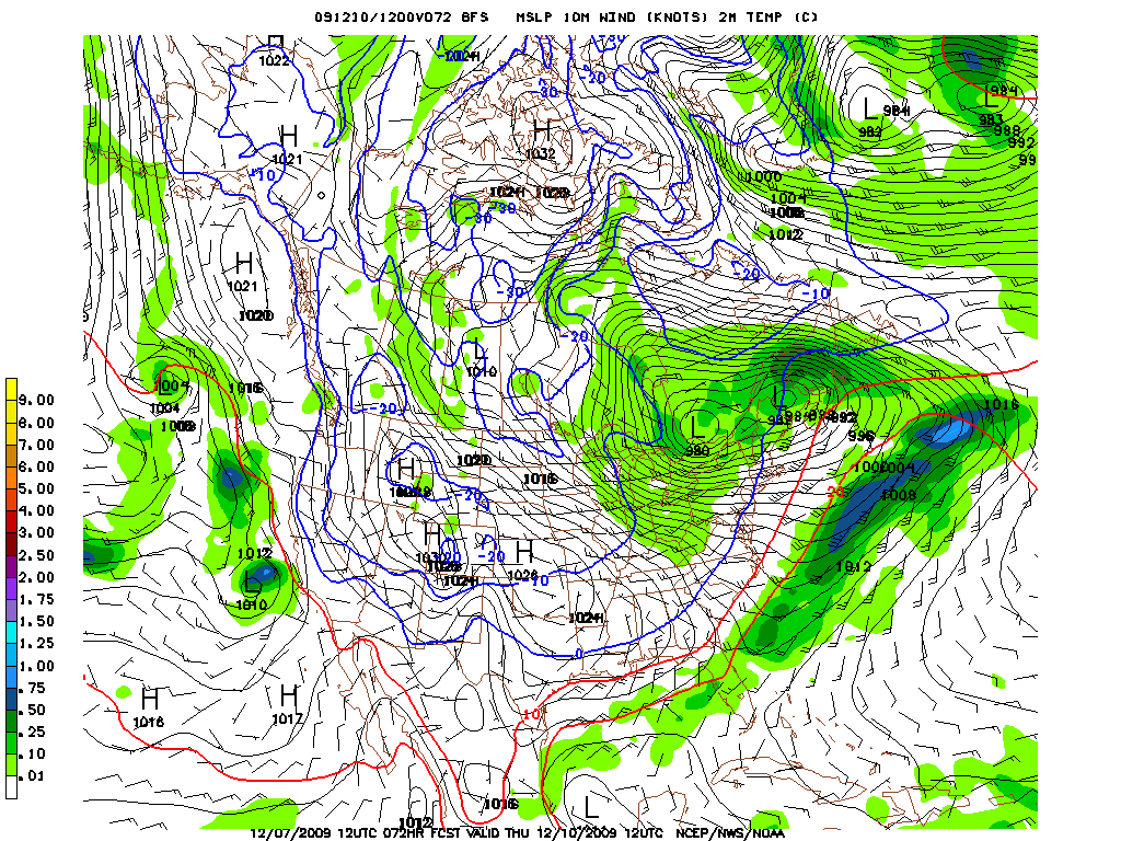
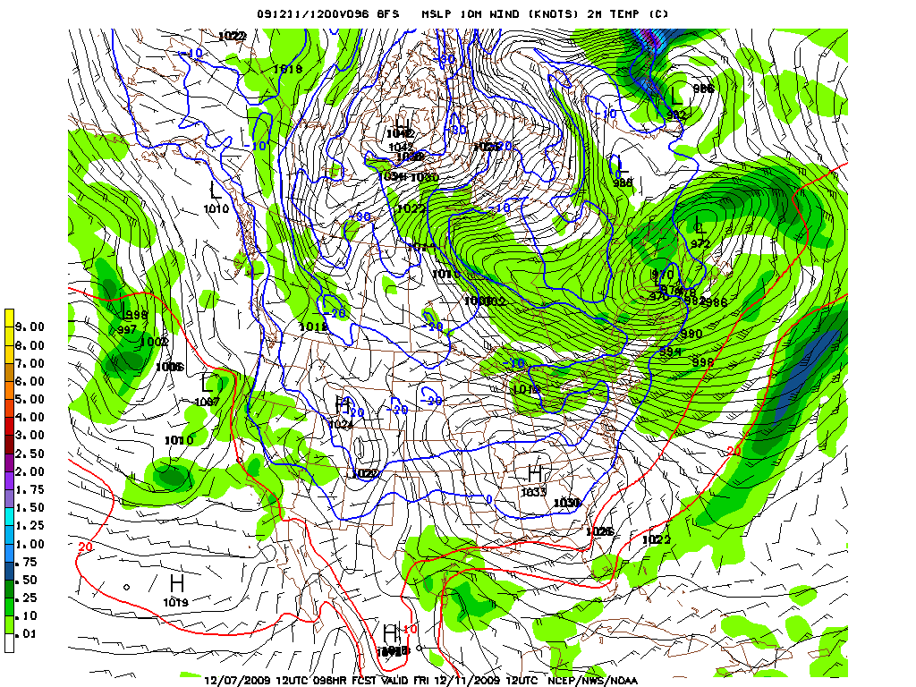
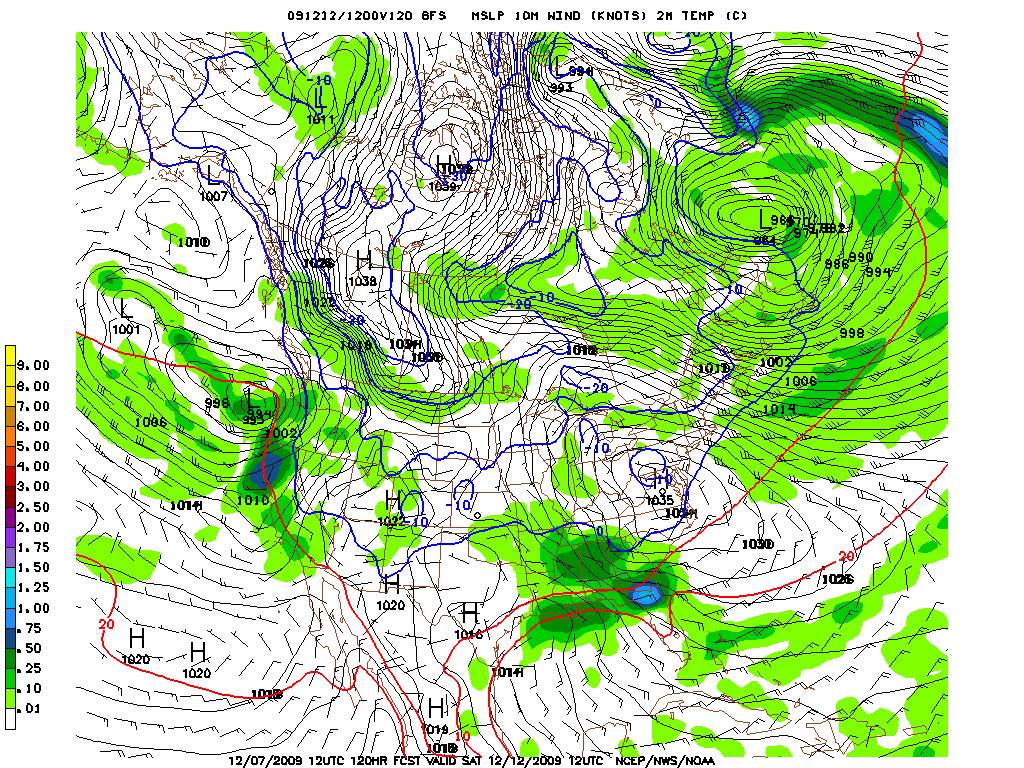
Total Precip:
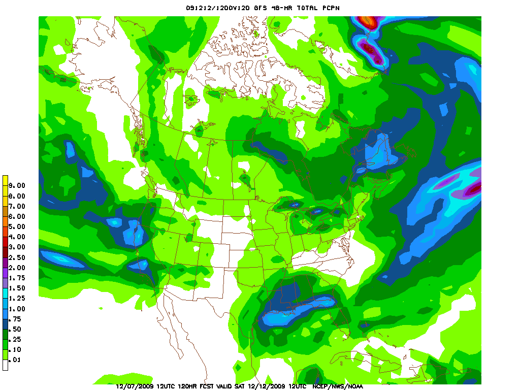
I’m not really going to go into totals right now because it is far too soon for that. However I will state that after wed. storm we need to carefully watch the radar and winds to see where these bands develop. Anywhere from the catskills north and west to the spine of the greens could pick up a few unexpected inches from this set up.
UPDATE:
Latest thoughts on midweek storm:
As scott and I talked about yesterday, the NWS has said that 3-5 total accums possible in the valleys with 4-8 possible across the higher terrain with the snow coming at the front end before warm air works into the midlevels of the atmosphere and changes the precip over to sleet, freezing rain and rain.
Looking at the minute details a few key points.
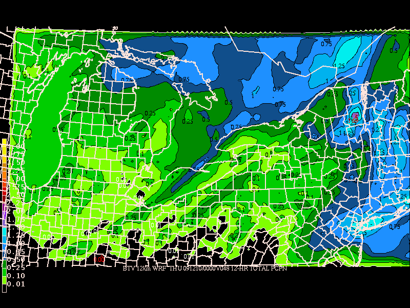
1. Upslope snow will not fall in normal upslope areas. We’re looking at precip coming in from the w/sw and with strong winds from that direction I’d look towards sw facing slopes of the adk for the best accum.
The total precip map by the high res WRF supports this:
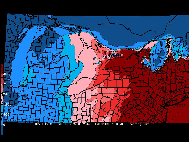
Now the real question is how much of this will fall as frozen stuff?
As you can see, the warm air and downsloping winds will warm the entire area with just the adk and northern greens staying below freezing:
By wed night a mid level dryslot will move in at just about the same time that the h85 temps cross the 0c line in the adk and northern greens. This should save these areas from changing over to all rain. However this isn’t a bet i’d want put the house on. There is def. the possibility with 850mb temps just at freezing and temps above that above freezing the mountains will get some cold rain wed. afternoon.
Notably, it seems that the adk will cool down before the greens as in the wake of the dry (and warm) slot.
In the wake of the system it still looks good from some real Lake Effect
Total precip. predictions by thursday morning clearly show bands setting up right into the tug hill and southern ADK.
-Also- upon request- Tremblant 6-10 inches
14 Comments
Leave a Reply
|
|||
| Home |




MadPatSki
wrote on December 7th, 2009 at 4:07 pmKids december madness at school week starting on the 10th, for those who can get away…have fun. Looks like Massive Flakes might fall again.
Doremite
wrote on December 7th, 2009 at 6:20 pmPlease refrain from further updates unless they are forecasting all snow for the northern greens Wednesday-Thursday followed by copious quantities of lake effect to follow. Sounding pretty upside down right now with most of the new snow getting cryonically frozen in carbonite. Need to kick this season into season.
bum
wrote on December 7th, 2009 at 11:05 pmsnow’s a funny thing. without throwing out numbers, the snow that may fall after the synoptic/main event on weds. looks to be pretty light-density. depending on how the temps go, and if/when this lighter snow falls- it could bond well with the slop, or not. only time will tell.
bushman
wrote on December 7th, 2009 at 9:48 pmForget the weathertechtalk and highend meteorologicspeak.Jay says it picked up 3-6 today with dustings expected tues and weds AM. Even if it gets damp weds night, we expect it will snow thurs so by friday, so when we unload the chair we’ll be 12-16″ on top of damp stuff that’ll be stiffened from the colder temps, covering rocks, stumps, cut brush in the glades. Nuff said.
bum
wrote on December 7th, 2009 at 10:22 pmI wouldn’t place any bets yet. Jay can get slammed, or get nothing, or in between. nothings in stone. its too far out to make any calls on lake bands/upslope. hopefully, some good will come after the mess.
rdennhs
wrote on December 8th, 2009 at 10:17 amThanks for the update LH
Chris
wrote on December 8th, 2009 at 11:25 amWhat do you guys think of Saddleback’s chances to stay all snow?
In that vein, wondering if you could perhaps add a bit on the Western Maine mtns every now and then for your reports. Love what you guys do but everything seems to stop in the Northern Whites.
Saddleback pass holder would love to know when we’ll get the goods!
Thanks
Lionel Hutz
wrote on December 8th, 2009 at 11:38 amChris,
A) Saddlback will likely stay away from the worst of the mixed precip. I’d put them in the 4-8 cat with the potential for a little more.
B) “Western Maine mtns” – did they get the phonograph yet up there? Do I have to pony express the forecasts up to you all via sled dog (yes the pony express used sled dogs. I’m a history major. Don’t question me on these things).
Greg
wrote on December 8th, 2009 at 1:46 pmThey’ve advanced to the courier pidgeon
Chris
wrote on December 8th, 2009 at 11:47 amHaha Thanks LH….appreciate the input
Western Maine is really a beautiful place…Great 4 season destination to enjoy the outdoors. And don’t sleep on Saddleback….place is legit and getting better all the time!
WCSH6 in Portland has 9-14″ up for Rangeley so I hope you are just being a bit conservative on me!
Greg
wrote on December 8th, 2009 at 1:47 pmChris… I don’t squat on Saddleback at ALL. I was up there two seasons ago in LATE MAY, and the cover was still legit. I never made it over last year, but I think this is the season! I bet you guys have all sorts of untold wonders in all those glades you’ve got going on.
Lionel Hutz
wrote on December 8th, 2009 at 2:14 pmNothing against saddleback…any ski resort is cool by me.
Long range after the storm- great riding conditions by the weekend before xmas.
Keith
wrote on December 8th, 2009 at 8:12 pmreally cold in KV right now! your high res WRF puts the bulleyes on essex ctny! hope your right. Adirondack backcountry and WF/Gore need some luv and a foot – foot and a half of dense snow that packs up w/ onslaught of ripping winds would really help build us some base!
Joel Gratz
wrote on December 8th, 2009 at 11:52 pmExcellent weather write up. I provide similar info for Colorado here: http://www.ColoradoPowderForecast.com For my friends back east (where I’m originally from), where do you get the high res WRF maps? Thanks!
Here is another resource for high res modeling, though can’t speak to its accuracy in the east: http://fireweather.sc.egov.usda.gov