UPDATE — OCTOBER 6, 2012 — 7:16 AM
Despite no clear model consensus, I think I’ve figured out a reasonable solution. As of this morning I think we’ll see a weak surface low pressure develop around NJ sunda am and move N/E along a frontal boundary. The long wave trough spawning the low will remain tilted in such a way so as not to inspire any real deep cyclogenesis, at the same time the front will remain juuuuuust a little too far to the s/e to provide any real heavy precip to the region. Notwithstanding those two points, enough moisture should be drawn to the N/W of the low to allow for some accumulating light snows across the very highest terrain of central VT and NH. Right now the best chances for any accumulating snows will be on a line from central VT through the Whites and on into s/w Maine.
Totals are a little funky. The grounds warm and wet so a lot of what falls will melt instantly. Get a cold patch where stuff can accumulate…like the high whites…and 3 -4 inches are def. possible. I’ll keep watching because this certainly has the ability to develop further. But for now, thems my thoughts.
Have a good weekend.
end update
Well, here we go.
Over the past few weeks I’ve mentioned (here, here, here, and herehere) the first weeks of October had begun to look very supportive of winter weather in the N/E.
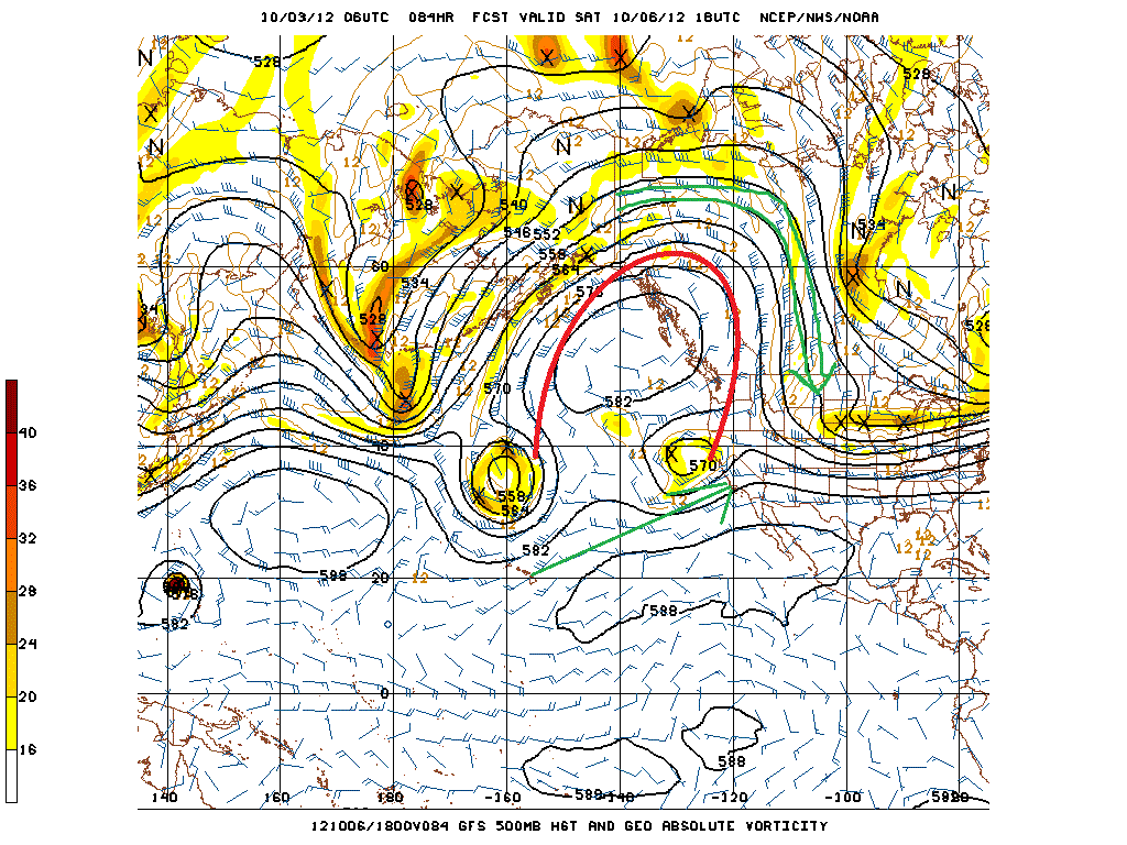
Why? Well the answer lies in the development of a large Pacific ridge (as depecited below).

What we see here is a large ridge (marked in red) developing over the eastern Pacific. This does several things. First it splits the flow of pacific air entering the country into two distinct streams (green lines). One stream is air flowing up around the ridge and dumping into the United States straight out of northern Canada. This air, as you might expect this time of the year, is pretty chilly- certainly cold enough to support winter weather. The second stream flows from the sub-tropical pacific bringing warm moisture rich maritime air into the United States. This is a pretty good recipe for the development of winter storms in the eastern 1/2 of the country. Where any particilar storm develops in the eastern half depends on a number of factors. If the right conditions come together over the plains the storm might get sucked in the Great Lakes and maul Chicago. If the ingredients come together a little further east, we in the n/e can get pounded. Regardless, the development of this ridge/ split flow regime is pretty favorable.
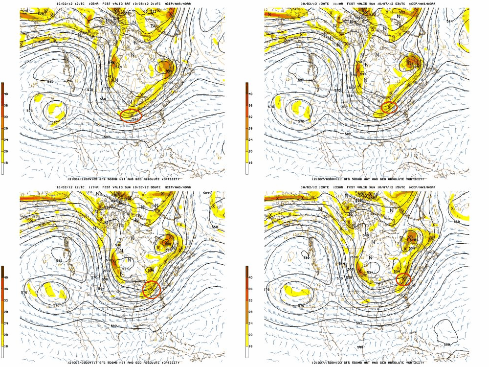
The recent model runs show why. I’ve clipped yesterday’s 12z GFS run for you here.
Essentially what we see is a 500mb piece of energy (vort max marked with an X and circled in red) swinging in through a trough on the northern stream – referenced above). It moves east Sat into Sunday.
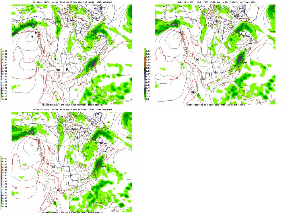
Vort-maxes promote upper level mass divergence and surface cyclogenesis east of the vort-max. With the path of that v-m, we should expect to see some surface low development. We did:

Notice that the storm (marked by the “L”) rides along the h85 0c line as it moves up. For a number of reasons that’s pretty reasonable. Were this to verify, somewhere high up along the spine of So. VT and/or the Whites would get a solid 8-10 inches of snow.
Comparing this to other models we see a lot of similarities. The Euro shows almost the identical 500mb structure and a comparable h85 structure. The CMC is suppressed but previously showed the same solution. The NAM isn’t in range yet, but at hour 84- the limit of the NAM- it generally matches the solution of the GFS and Euro.
Today’s model runs show a less developed “L” and moure suppressed solution. More of a frontal passage with weak backside flutter type event. However some ensemble members are holding very steady to the solution from yestreday’s 12z GFS. Setting aside normal model variances I strongly believe that something is afoot for the weekend. Right now I’d say our chances for snow this weekend are “interesting” and worthy of close consideration. I’ll keep you posted.
8 Comments
Leave a Reply
|
|||
| Home |


Jake
wrote on October 3rd, 2012 at 11:56 amLet’s get it the effffff ON!
FemaleSkiBum
wrote on October 3rd, 2012 at 3:26 pmPhew. Cause I can’t handle this lack of snow ny longer.
Keith
wrote on October 3rd, 2012 at 4:23 pmHell yeah!
Anonymous
wrote on October 3rd, 2012 at 6:42 pmAwesome. As a huge fan of meteorology and snowboarding I really appreciate the details regarding how the storm shapes up. The more specifics regarding the weather the better. Thanks.
icelanticskier
wrote on October 3rd, 2012 at 11:22 pmbut there’s no base!!!!!!!!!!!!!!!!!!!!!!!!!!!!!!!!!!!!!!!!!!!!!!!!!!!!:)
rog
tBatt
wrote on October 4th, 2012 at 8:02 amWhat’s the potential schussable timeframe we’re looking at? Sunday or Monday?
NutmegCharlie
wrote on October 5th, 2012 at 12:35 pmSounds like it’s time for some fast grass rock schussing! Yeeehaaawww!
mtl_ripper / powhounddd
wrote on October 6th, 2012 at 2:44 pmmmmm fresh…